Ranking: 3/5 As far as beach hikes go, and especially for someone just being introduced to the joys of backpacking, this is a good one to consider. Minimal mileage, and not a lot of elevation gain and loss, as well as lots to see as you wander down the coastline. To top it off, you can have a small fire while you camp on the coast…Water is available near by, as well, so what’s not to love?
Difficulty: 3/10 Yep, pretty easy as far as difficulty, I believe the most difficult thing we endured was finding a place to park at the 2nd Beach trailhead! There are two overland routes that might test the most uninitiated, but for the most part, this is a pretty entry level type of hike. Just don’t turn your back on the ocean when you’re in close to it, and enjoy wandering the wide open beaches!
Getting there: From Port Angeles, follow US 101 west for 55 miles to the junction with SR 110, signed Mora – La Push. From Forks, this junction is 2 miles North. Continue on SR 110, and in 7.7 miles at Quillayute Prairie, SR 110 splits. Take the left fork ( La Push Road), and drive 5.2 miles to the trailhead, for 3rd Beach, located on the south side of the road. You will pass the Quileute tribal office.
Permits/Reservations: Obtain permits in person ( $8 per person per night) at the Wilderness Information Center in Port Angeles or the South Shore Lake Quinault Ranger Station. No reservations for South Coast. However, Second Beach is very popular in summer and can fill up. Will also need a permit to park at TH, either a NorthWest Forest pass, an America the Beautiful Pass, or equivalent.
Maps: Bought a nice Custom Correct map at the WIC for the South Olympic Coast, or you can get a MyTopo map made.
3rd Beach to Toleak Point GPS trail added 7-17-17
For the first hike of the year, we decided on a trip headed south on the Washington coast from 3rd Beach, a section we’ve not yet covered…All of our forays to date have been north of Rialto Beach and the rugged coastline there.
“… Appears that I had been saying it all wrong…”
This will be Maria’s first backpack, so every effort has been made to make sure it won’t be her last, so no 16 mile death marches on this one…Instead, it’ll be around 8 miles from 3rd Beach south to Toleak (pronounced Toll-e-ack!) Point, a good trek to start out on. Appears that I had been saying it all wrong, as the spelling to me seemed to be more like a response to your buddy’s question of, “Dude, where are you going?” as you headed for the bathroom door…

Since it’s a long drive from Puyallup, we spend our first night at Forks, so the drive to the trailhead in the morning will be less painful.
Getting up in the morning, we pack the truck and promptly head for the trailhead, completely forgetting about breakfast.
As we arrive at the parking lot, we’re dismayed to see that all the spaces are full! Just great! What now? As we drove by the packed trailhead, I’m thinking, there’s no way we’re missing out on this hike, so after turning around and doing another drive-by, we manage a spot at the edge of the parking lot, tail end backed into the brush, but we’re here!!!
Day 1
6.6 miles, 788ft gain/821ft loss…fitbit steps 25,423. With packs finally on, we head down the trail, a well maintained path that begins like a two lane highway, wide enough to walk two abreast. It goes for about 1.4 miles through a typical coastal rainforest, with mixed evergreens creating a canopy overhead, and the forest floor covered in Salal, fern, huckleberry, and Salmon berry.
After the 1.4 miles of flat terrain, we finally head downhill to the beach, the sound of surf breaking on the beach signals we’ve arrived…
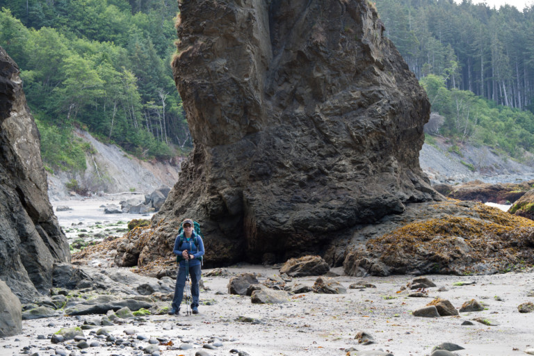
The trail dumps out on a nice wide sandy stretch by a stream, with some tall spruce and firs, and there are several tents already pitched here in the tree line as well as on the beach. There is some driftwood here to use for firewood. To the right, you have a cliff that juts out into the ocean, and some large sea stacks just off the low tide mark. The sand is well packed, so it makes for easy trekking as we make our way south.
“…we feel as if we’re being chased by the only black cloud in the sky…”

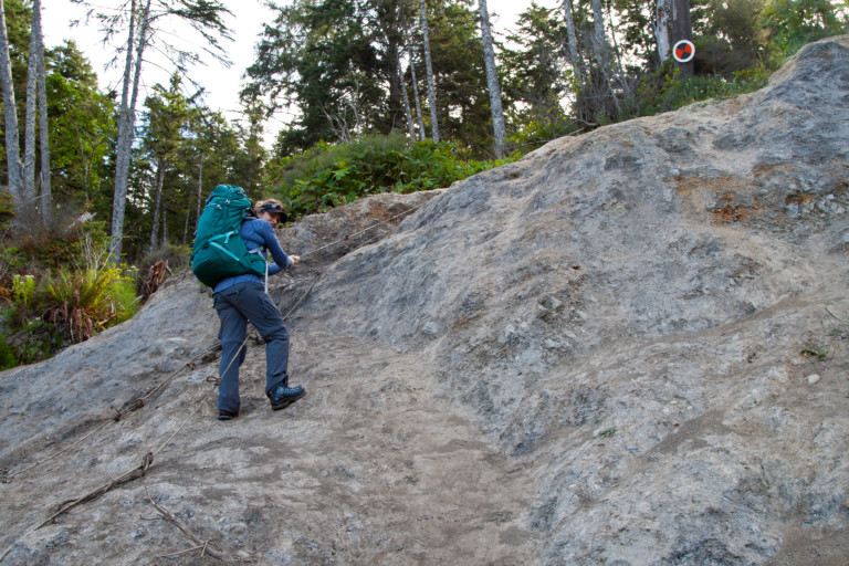
We come to another point that requires an overland route at mile 1.8, and it is relatively steep and muddy, probably from the recent rains. In fact, we feel as if we’re being chased by the only black cloud in the sky, as it drizzles on us occasionally.
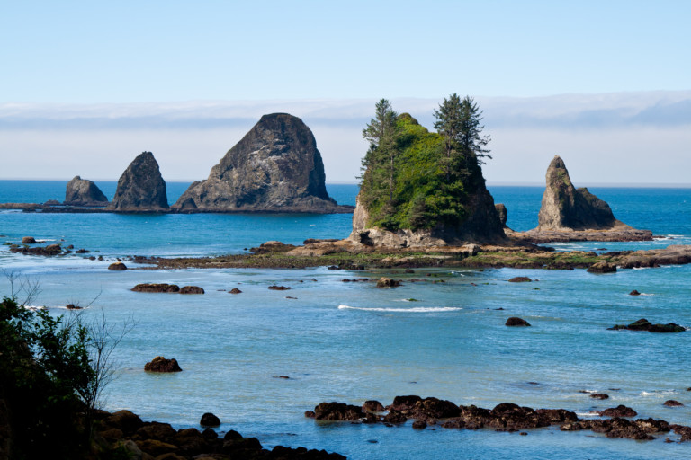
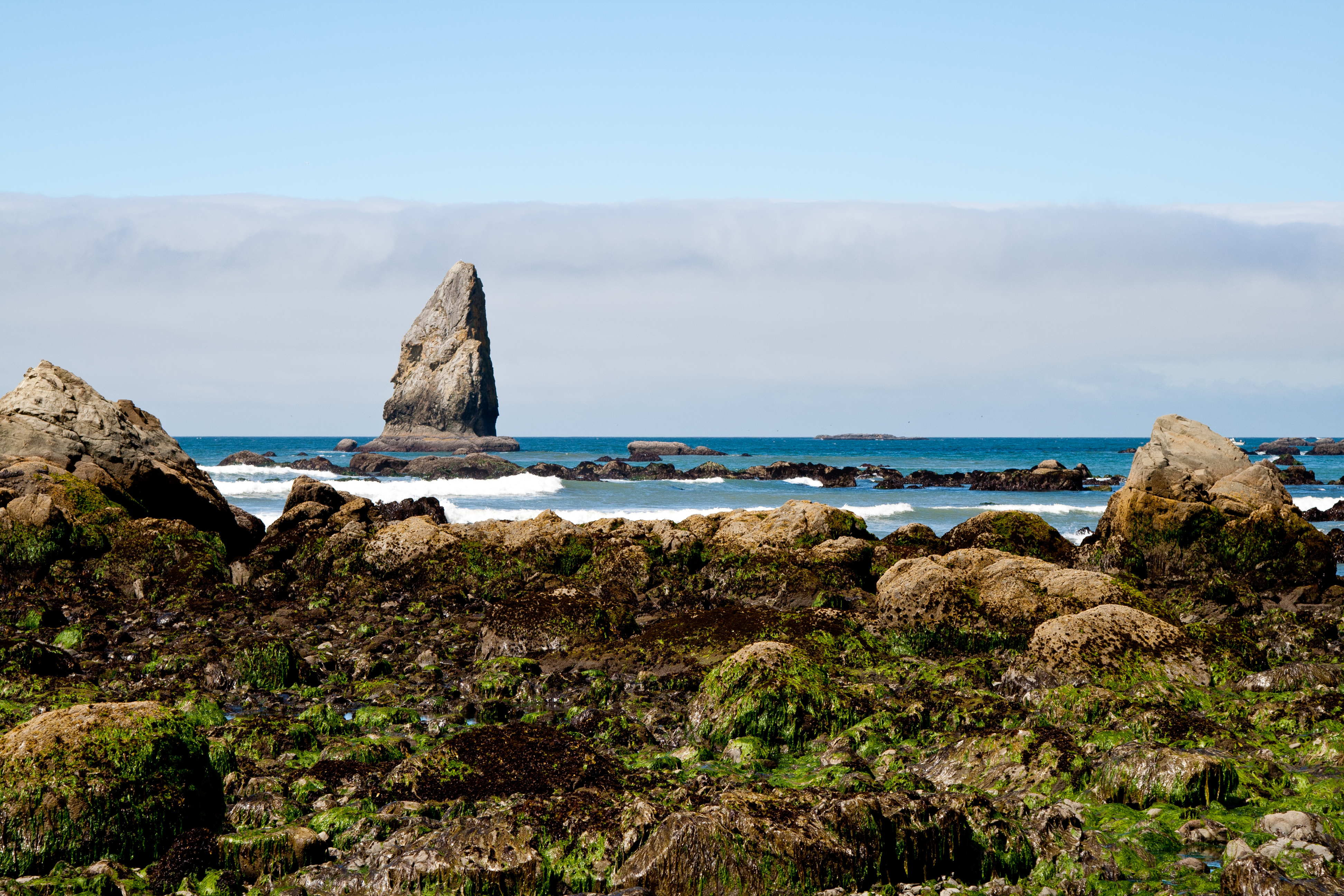
To help navigate the muddy slope, a rope with knots tied in its length for handholds is anchored at the top of the incline, and it makes it easier to pull yourself to the top. Once safely on top, its another 1.1 miles of forested walk to drop down to another beach, this one more rocky and beautiful. Several smaller sea stacks stick up like fingers here on the rocky beach, and looking between them, you can see the Giants Graveyard, a cluster of large sea stacks Rising up from the calm ocean in the distance. A truly scenic vista, and we stop to take pictures before venturing on.
Now its another .58 miles to another quick overland trail, that’s only about .28 miles long, and once on the other side of this, it’s about 2.5 miles along sandy beach, sometimes wide, until you reach your destination at Toleak Point.
A beautiful and scenic walk along the coast that at times, we had to ourselves, and it felt as if we were the last people on earth, with seabirds and the occasional Eagle cry as accompaniment to the constant, but peaceful surf, ebbing and flowing along the beach, creating a soothing soundtrack to accompany our foot falls going “scritch, scritch” across the sand…
Before we know it, our beach walk has ended and we reach Toleak Point in about 3 ½ hours. One of the better sites is available, complete with fire ring and logs for seats, just north of Jackson creek.
The path that leads up to the “facilities” is near this site, too, marked with buoys that have washed up in the tides, and someone has re-tasked them to be trail markers…

We set up camp, collect some driftwood for the evening fire, and pump some water. Still early enough so a nap seems in order and we take one even though it’s hot in the tent from the early afternoon sun that has managed to chase away the lingering clouds.
It’s so peaceful here, a nice break from the routine of everyday life. After getting up, we wander the beach a little further south, before returning to start dinner.
“…30 seconds later, I smell….Something burning, and it’s not good…”
I break out my new MiniMo Jetboil and new Sea to Summit collapsible pot, and begin making dinner. 30 seconds later, I smell….Something burning, and it’s not good, like melting plastic. Quickly, I pull the pot off, to make sure it’s not melting, as its silicon sided, and no….It’s not the pot melting. I look at the stove, and am shocked to see the plastic underside of the Jetboil burner is melted, some of the plastic has fallen away from the metal frame, looking like foam dripping down the side of a coffee cup! I’m in disbelief, as I’ve never seen a stove fail like this before.
“Really, I’ve never seen one do this before!”
I tell Maria, “Really, I’ve never seen one do this before!” And, I’m wondering now, how in the world and I going to finish cooking dinner? Clearly, there’s a problem now, and I’m unsure at the moment just what caused the dang thing to melt down like that…Right about the time I’m in the middle of my slight bewilderment about what just happened, the park ranger walks up to chat with us, and after a couple minutes, I ask him if he’s ever seen a Jetboil fail like this before, and surprisingly, he says, “Yes!” He said he too had a pot just like this one and he said his friend put it on the burner like this and melted his the same way…
“…It seems a delicate little flower…”
Apparently, the reflected heat from the pot set directly on the burner melted the plastic, and then it dawns on me!!! I forgot to put the pot stand-off on!!!! DOHHHH!!!! Then, I remembered that I had forgotten to bring it, as it was still at home! The reason? Well, if you try and put both the pot support for the pot, and fuel canister into the velvet pouch, they both won’t fit no matter how hard you try and shoehorn them in, so…I forgot to pack it! They all fit so nicely together in my old Jetboil… Sighing, I thanked him for the enlightening info, and fashioned a couple sticks to hold the pot above the burner, and as
long as I used a lighter to start the burner (the piezo-electric starter didn’t survive the molten plastic), we were able to cook our meal. Equipment fail #1…Fail #2 was me cracking the top of the new Sea to Summit pot. It was good when I packed it for the return trip home, but after pulling it from the pack at home, the lid was cracked…It seems a delicate little flower, as my friend Greg’s is also cracked…
After dinner cleanup, we started a fire and enjoyed the flames company until it was time to turn in. A complete day on the coast!
This route from Third Beach to Toleak Point offers an up close and personal experience beside the pounding surf of the Washington Coast.
Yes, it does, a great way to easily get out and experience some of the wild northern portion of the Washington coast!
Glad you stumbled upon it, and that I had some useful information for you…Have added a few more for 2017, and still more to come as the backpacking season unfolds…Again, thank you so much for the kind words!!