Ranking: 2/5 Yeah, another low-ranking on a trail…Seems we’ve done a few of these lately, but…It all looks good on paper, until you put boots on the ground…You spend a lot of time trying to get somewhere on this hike, and the long-tree covered approach can be a bit mind numbing…Not much to see, but once on top, there are some good views. Still, too much effort for little reward.
Difficulty: 9/10 Some pretty strenuous uphill will be required to get up to Crater Mt. And, when researching this hike, the trails seemed to go by many names, like Crater Creek, Canyon Creek trail, Ruby creek trail, and Jackita Ridge Trail…Seems some of that could be cleared up. And, once on the Jackita Ridge trail that leads up to the cut-off that leads to a tragically misnamed turn off to Crater Lake, (think of it as more a shallow tarn than anything resembling a lake), the trail markings aren’t that obvious. Like the trail that leads up to Lookout #2. Not marked. Neither really, is the old trail that leads up to the spot where Lookout #1 used to be..Not many campsite locations around the “lake”, and there is no John T Crapper there, either. On your own. Which, I would expect for a site like this.
Getting there: Follow I-5 north to exit 232, turn right on Cook Road towards Sedro-Woolley, and go 4.2 miles to a traffic circle, take the 2nd exit to stay on WA 20E towards Ross Lake, and follow for 76 miles. Canyon Creek trailhead parking lot will be on the left.
Permits: Will need a Northwest Forest Pass or equivalent to park at the TH. Self-register at the TH board.
Maps: We used Green Trails Map #49, but also suggest using a custom TOPO map of the area.
Crater Mountain GPS added 9-24-17
Well, originally, this hike should have been named the Rainbow-McCallister Lakes loop hike, but it wasn’t to be…Since it was in the North Cascades National Park and there were no reservations allowed for the loop, it ends up being a crap shoot on whether or not you got a site. You can show up no earlier than 24hrs in advance and they don’t take phone-ins, so you won’t know until you show, so to speak…Well, we showed, but it was a no-go for us, all the sites were taken…
We spent about 20 mins there at the North Cascades ranger station poring over maps, trying to figure out an alternative, and with lots of questions, we figured we’d hike up to Crater Mountain, which was outside of the park boundaries, in the Mt. Baker Snoqualmie National Forest. The ranger was helpful, and he said, “Oh, yeah, it’s pretty scenic up there when you get to the top, and there’s even an old lookout you can hike up to. And, if you’re adventurous, you can even wander out onto the glacier.” Ok, cool, we thought, that might be a good place to go…”And”, he added, with typical understated Ranger-ese,( like when you’re doc says, “this will only sting a little…”) “It’s a little steep on the way up. A lot of switchbacks, but you should get there in time to do some exploring…” Then he handed us a trail report book, with an entry that someone had added. “It kind of explains where to find water, and how many switchbacks”, as he pointed out in the entry, that the person had counted 63 of them…Wow, that seemed like a lot, but hey, we can do it, right???
Day 1
9.6miles, 5890ft gain/1995ft loss fitbit data: 32,829 steps
Of course, we didn’t have a map of the area, so we purchased 2 Green Trails maps of the hastily planned hike, thanked him for his help, and headed out to the Crater Mt. trailhead. Which, by the way, is actually the Jackita Ridge trail #738. It’s a little confusing, but once on the right trail, easy enough to find your way.
“…Granite Creek Guard station, which of course, has not been manned for several years, given its current state…”
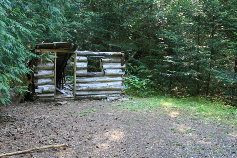
By 9:30am, we had parked and were on the trail, across one nice bridge, then a little further on, a bridge across Canyon Creek, crafted out of an old log, next to a fallen down old cabin. Guess it was originally built in 1903 by 3 sailors who came to the area on a fortune tellers advice to “Go North, young men in search of gold!”. Which, of course, they never found. Then, the cabin was taken apart and moved, piece by piece to its current site by the creek and was used as a guard station for many years. Believe the name of the place was the Pettigrew cabin? My memory kind of escapes me on the exact naming, and of course, I didn’t have anything to write it down with when we left…The TOPO maps show it as the Granite Creek Guard station, which of course, has not been manned for several years, given its current state…
Once we crossed the bridge, you come to a T, and go right; otherwise, you’re heading down Ruby Creek trail back towards Ross Lake. Turning right of the bridge in short order you come to a trail registration board and you will see that this way is the Jackita Ridge/Crater Mountain trail, #738. After signing the trail register, we follow the trail up, it’s in good shape, a little brushy in places, but not so that you can’t see the path, and it begins a steady but not steep uphill, through deciduous trees and brush that steadily give way to old growth fir and cedars. Nothing huge, as far as trees go, and their trunks, as you climb, get thinner and thinner.
“…as the relentless upwards slog can really help to lose count…”

At mile 1.8, you reach the Pasayten Wilderness boundary, and from this point on, is where the serious uphill seems to begin. To break up the monotony of climbing steadily uphill, you can start counting the switchbacks. I believe I counted 55 from the boundary point, but one would have to forgive me if I miscounted, as the relentless upwards slog can really help to lose count…
One after the other after the other, constantly under the canopy of trees, with nothing to look at but trees. I guess I shouldn’t really complain, though, as it was a hot day and if the switchback marathon were done under the unrelenting sun, it’s possible I would have melted into a puddle…Not much talking going on, just concentration on making the body move forward, one step at a time…
I didn’t know it at the time, but as the trail finally began to flatten out a bit at the top, I stopped about 100ft from the Crater Creek junction to get the pack off my back, that I was sure was loaded with 100lbs of rock, and rest a bit. As we were sitting there with the load off, we could hear voices up the trail.
“…not unlike little Ralphie and his bro in “A Christmas Story”

Rest break over, we hiked up trail towards the voices, and came to a wide spot in the trail and the here is where the junction was that we needed to take, 4.18 miles in, and over 2000ft of elevation since we crossed over the Pasayten Wilderness boundary. The source of the voices came from two guys seated against a fallen tree, just off to the side of the trail. It looked like one of our campsites, as bags of gear were strewn all about this small clearing like a derelicts camp. I say that, because when we get to a site, it’s bag open, then start tearing out bundled gear, tossing it to the left or right, not unlike little Ralphie and his bro in “A Christmas Story” chucking their sock presents over their shoulders…
They were sitting with their bug screens on snacking on something, and they said, “How were the switchbacks?” I assured them, it was something that I wouldn’t have missed for the world…Did I mention why they had their bug helmets on? Well, the biting black flies were horrible. Whenever you can sway at them biting your legs, and end up killing 3 or more of the little buggers with one blow, you can be sure there are just too damned many of them to be pleasant…
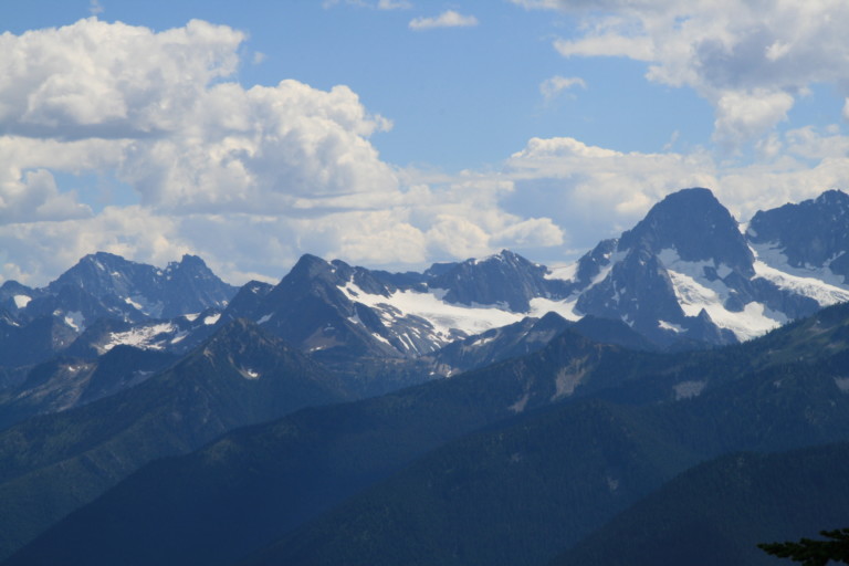
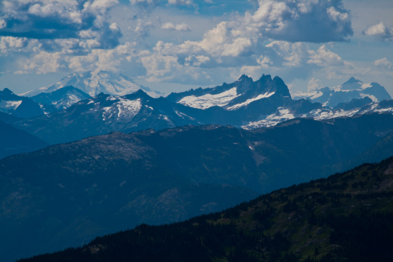
We take the junction up, and continue ever uphill…Not too far up the trail, we come to a good clearing on the hillside, no doubt clear because of endless avalanches that came roaring down, which gives us our first wide open views of the mountains opposite us. Jagged peak after jagged peak, usually with snowfields or glaciers sitting at their bases, seemed to go on forever. I believe we were looking at Mt. Degenhardt, Mt. Terror, and the Terror Glacier…Row after row of billowy white clouds were just scraping the tops of the highest peaks like waves crashing on a beach, make the pictures we took even more interesting.
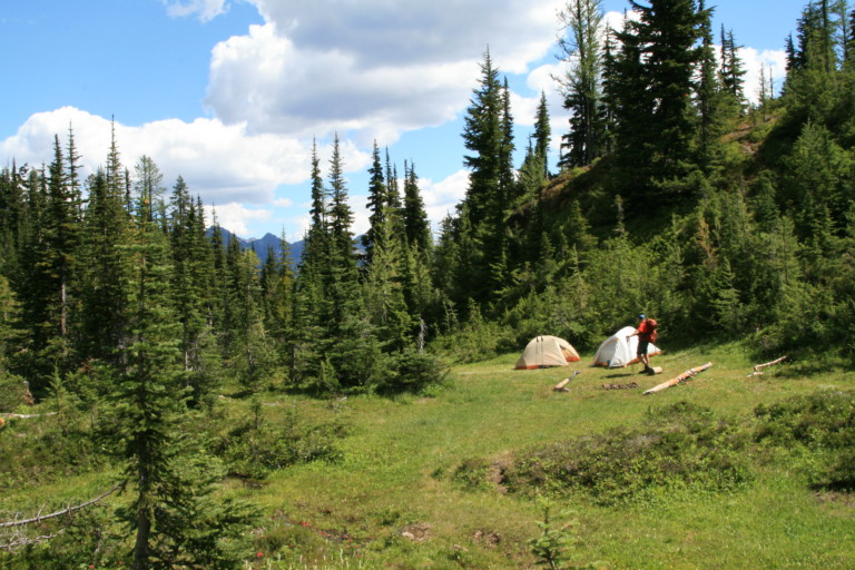
Finally, we reach the base of Crater Mountain and a little tarn that covers about a 1/3 of the flat ground here in this natural amphitheater of rock. At the outlet, on the south side of this shallow pool of water, is a nice grassy meadow where we choose to set up camp, or should I say start jerking gear out of our bags and toss around haphazardly?
“oh, the trail up is splendid, but we didn’t make it to the lookout…”

Before I forget, though, we did pass some day hikers before entering this basin, and a particular duo bears description. Clearly, a guy in his 60’s with his son that stopped to chat for a sec. We asked them how it was and the older guy mentioned that they had gone up to the lookout like the ranger had suggested, and he said, “oh, the trail up is splendid, but we didn’t make it to the lookout.” “Oh?” I asked, “Why is that?”“Well”, he said, “the last 50 feet is a scramble and we didn’t want to go up…”
“…These words will come back to haunt us, I assure you…”
As they left, I remember Greg and I looking at each other, and Greg says, “Man, if its only 50 feet, why not go the rest of the way up? If you come this far, might as well got the rest of the way, right? Right?” These words will come back to haunt us, I assure you…
We managed to get here at 12:30pm, plenty of time to explore if we choose to, and after emptying the contents of our packs, and setting up camp, we take a few minutes to look around.
As I mentioned earlier, this tarn is shallow, it might go over your ankles, but just barely…It’s littered with a few large boulders and dead trees, so it’s not a beauty at all…You can hear water falling, and across the other side of the tarn is the steep black rock walls that rise up to create this natural amphitheater; more accurately, the rock is a batholitic…
The walls are sheer, so they are mostly bare, and then it comes to a ledge which from here you can’t see what lies beyond, to the top of Crater Mountain, and you can see how it got its name. It does form a crater on top, like a saucer that was tipped on its edge a little, revealing the inner side, like a cupped hand. In the middle of the bowl there was a small snowfield. To the right of Crater Mountain there is another double peaked ridge of black rock, aptly named “East Crater Mountain”…Pretty much both just ugly outcroppings of bare rock, not much to look at…
We surmised there must be large snowfields up there, just beyond the ledge that are feeding the long cascading waterfalls, more like thin braids of water than anything else, falling to the basin we’re standing in.
Well, now what? “Wanna go up to the lookout?” Sure, we got time! So, at 2:30pm, we head up the trail from camp on a pretty well defined trail and it continues the day’s pattern of mostly up…Through small larches, alpine firs and huckleberry brush until it thins out to mostly an orange tan colored rock. Once you gain the ridge, in about a mile, you have spectacular views in 180 degrees, and you can even see Mt. Baker. On this day, the upper portion was obscured in clouds, and a fine haze that filled the air. Didn’t exactly make for a good photograph, but still good for looking at all the spectacular peaks that stretched on as far as you could see. It was easy to understand, from this perspective, that the North Cascades was nick-named the American Alps.

“Mad props to the old guy for coming this far!”

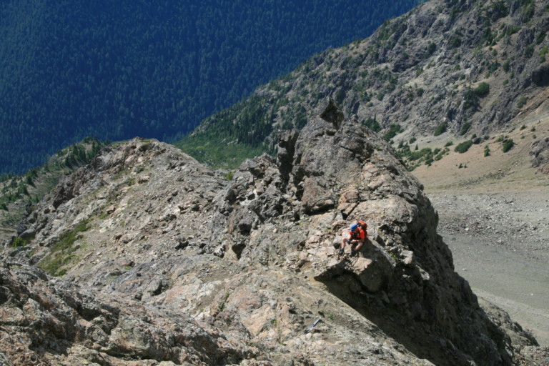
The trail winds its way uphill along the ridge switch backing here and there until it pretty much disappears altogether near the should of the mountain, where the color changes from orange to black, a few cairns mark the way, until we round a steep ravine, and begin a 3 point scramble up a narrow slot, filled with loose dirt and scree. At the top of this narrow slot, we can see where someone has fashioned a cross of sorts out of sticks, like X marks the spot. By this time, we’re both thinking, “Mad props to the old guy for coming this far!” At the stick X, we sit on top of a narrow ridge, and still there are cairns further up the ridge, urging us on…It’s now after 4, our turnaround time, but still I’m curious to see if I just climb up a little further, maybe I can see the still hidden lookout location? I clamber further up, along a very narrow ledge with 0 margin of error, and have my camera bag catch the grabby rock, and pull…Looking down from where I’m at now, as I catch my balance again, I can see that you’re dangerously exposed here, once misstep, and it’s game over.
I decide that since I can see no end in sight of doing a four point scramble from here on up, that Its time to head back down…That, and I can hear the sound of loved ones voices swirling in my brain telling me to be careful. Also, the feeling that since I was trying to be careful, and was thinking about it, I felt a little bit as if I was losing my edge and sense of confidence. Something that here you definitely want to be bringing with…
We retreat over a couple dicey sections, back to more level ground, and make it back safely to camp around 5:30pm. We both marvel at what the old guy said, about making it 50 feet from the look-out. Man, he must have made it further than we did, cause we felt as if we were climbing the damn mountain!
“… I unfold the map, and….DOH! Look at that! It shows not one, but two lookouts!!!”
Back in camp, I was curious, and drag out the Green Trails map. Where in the heck was that dang lookout? Was it different than what my GPS showed? Just beyond the next rock outcropping? I unfold the map, and….DOH! Look at that! It shows not one, but two lookouts!!!
And, it appears the one we reached for was lookout #1, and the maps show it right on top of Crater Mountain! No wonder it felt as if we were climbing the whole damn thing…
There, on the map, was a trail leading to lookout #2, its trailhead we’d already passed on the way in, and it listed it as 1.2 miles, and sitting on the edge of the Jerry Glacier! Now, it all made sense, for we could certainly tell it was over a mile up that ridge, and there was certainly more than just a “50 foot scramble” to the lookout! I felt a little bit better now about our effort to get to the lookout except of course, for my legs…They surely didn’t feel that good after all that exertion…In fact, they were a little bit pissed at my decision to lead up to the wrong lookout. Have you ever been to a mountain where there were two lookouts and one was definitely the wrong decision? It was another first for me, and not the kind of “firsts!” that I was looking to make…
“…that’s one little annoying pest whose reign of torment had just ended…”
Dinner done and we entertained ourselves with Greg’s new toy, the Executioner, a small bug zapper fashioned to look like a small tennis racket. Hold the button in, swing it wildly at the little blood suckers flying about, and if you were good, or lucky, or both, you would get a satisfying “snap!” accompanied by a small blue flash. This would invariably be accompanied by big foolish grins supplemented with gleeful laughter knowing that’s one little annoying pest whose reign of torment had just ended…
As darkness filled the amphitheater, we saw a couple of brilliant arcs burn out across the sky, the early entries of the Perseids meteor shower.
“…They just kind of waller around in there, like giving a six year old a size 14 shoe to wear..”
Time to turn in, so I break out the toothbrush, scrub the pearlies, and slip in my retainer, and…What the?? Did I put them in wrong? Sure feels like it, they don’t fit! Confused, I pull the bottom ones out, look at them to make sure that I do indeed have the bottom ones, put it back in, and nope…They just kind of waller around in there, like giving a six year old a size 14 shoe to wear.. They just don’t fit! And, the top one is all sloppy fitting too…All I can figure is I left them in the tent on a pretty hot day, so they must have melted somewhat. Weird, since I’ve taken them on hikes before in the heat! Guess I won’t be wearing those again….Ever…Since the day ended with us doing over 5800ft of elevation gain, sleep came quickly and easily. Also quick? Our decision that today would be the only day spent exploring this area, so we decide to bounce out on Saturday.
Thanks, glad you like it! And, I will continue to do my best to make sure all the information on the site is informative, correct, and useful…Again, thank you!!!