Ranking: 3/5 A great hike for beginners, as the trail is easy to follow and gradual. For most of the hike you are in the forest, and there isn’t a lot to see. Occasionally you cross a pretty creek, or come to wide, open meadows under the trees, and the trail dips down close to the rivers edge on many occasions, but mostly you’re in the trees for the duration. Reaching the Enchanted Valley itself, though, is surprising for its openness and the majestic peaks that surround the valley on either side, with hanging snow fields and glaciers on the upper reaches. Long, wispy waterfalls trail off from the high peaks in several places, creating a spectacular backdrop to the historic chalet that sits here on the Quinault River bank.
Difficulty: 5/10 The hardest part about this hike is the one-way length through old growth rain forest. It’s over 13 miles one way, which can be a lot in one day, hence the amount of nice campsites along the way, for those less inclined to do it in one shot. Otherwise, this is a pretty easy hike, just not a lot to see before reaching the Enchanted Valley.
Getting There: Head North on I-5 and take exit 104 and merge onto US 101N towards Aberdeen/Port Angeles, and go 6 miles. Then, continue straight onto State Rte 8 to Montesano/Aberdeen and follow for 21 miles. Entering Elma, you will continue straight onto US 12W, and drive another 20.8 miles. When you enter Aberdeen, the road turns into 101N, and follow the signs for 101N through town for 4.6 miles through various turns. Route and signs should be obvious…After turning left onto Perry Ave., US 101N, follow 101 for another 37 miles. Then, turn right onto S. Shore road, signs for Lake Quinault, and go for 4.8 miles through the small town of Quinault, and turn right after town to continue to follow the South Shore road for another 14.3 miles to the Graves Creek TH. Don’t forget to stop in town to collect your permit at the Lake Quinault Wilderness Information Center!
Permits: will need to pick up one at the Lake Quinault WIC. It’s $5 to register for group, and then $2 per person per night. Will also need a pass to park at the trailhead.
Maps: There are some good Topo maps of the region that you can pick up at the WIC, and you can of course, always use the Green Trails Map 166 Mt. Christie, and 167 Mt. Steel. Also, here is a great PDF map of the campsites available for the Olympic National Park, Wilderness Campsite Map.
Enchanted Valley GPS Added July 2015
Another foray into the Olympics! This time, Brian would go with us, and we leave Puyallup in high hopes of good weather, as it seems it’s going to cooperate for us once more!Again, it’s a long drive, and an even longer hike into the Enchanted Valley Chalet, our goal for this backpack, so we want an early start. We decide to drive over the night before and camp at the Graves Creek CG, only a half mile from the trailhead.
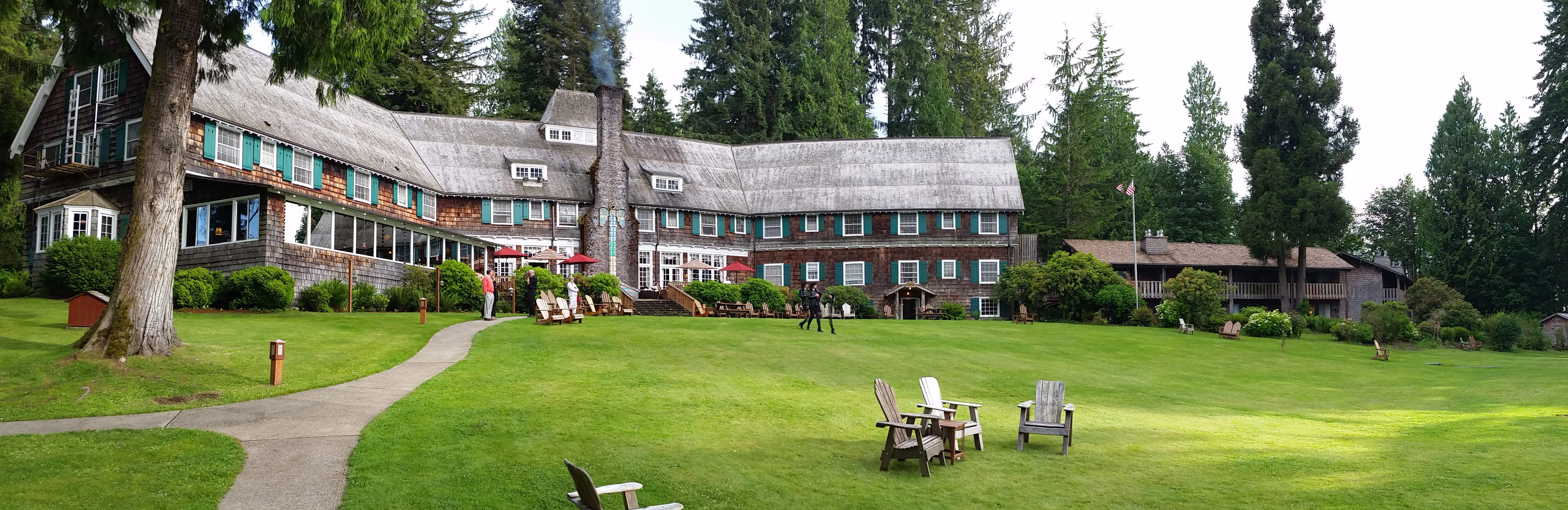
New territory for Brian and me, but it seems that Greg is somewhat familiar with the area, so we lean on him for “local” info! As we pull into the Lake Quinault area, we are pleasantly surprised to see the size of the lake, and the nice old lodge in Quinault, sitting in a pristine area on the lake, with manicured grounds.
After stopping at the ranger station to get our permit, we drive the 16.5 miles to Graves Creek to secure our spot for the night. The first 6 miles or so is narrow paved road, with the remaining 10+ miles gravel. It too, is narrow, and in places hugs the river’s edge, so attention is wisely paid to upcoming blind corners, for there are times you will have to look for a pull out spot to pass an oncoming vehicle.
There aren’t many spots at Graves Creek, so we’re happy to find a nice spot next to the river as we pull in. After setting up camp, we drive the long 16 miles back into town to get a nice bite to eat at the Salmon House Restaurant, with great views of Lake Quinault and good food as well.
While we’re in town, we decide to continue playing tourists, and check out the Lake Quinault Lodge. Very cool old lodge, a place I wouldn’t mind coming back to someday, to rent a room and just relax on its stately grounds.We drive back to camp, have a nice fire, and relax before our long trek up trail to the chalet.
Day 1
13.97 miles, 2524ft gain/1286ft loss.
We were surprised to see how full the parking lot was when we arrived at 7:30 in the morning! In fact, there was space for maybe 20 to 30 cars in the main lot, and we were lucky enough to find the remaining one! However, there were several cars parked along the road on the way into the lot. Seems a busy trail!
Once loaded up, we crossed the bridge over Graves Creek and headed up a wide grade, which looked to me as if it were following an old road bed for the first mile, making for some easy trekking. Old growth forest here, and it’s actually a pretty scenic jaunt over this first stretch. After the first mile, you gain 380ft of elevation over the next mile, as the trail meanders uphill through continuing forest. Once you top out, the trail begins a descent downhill for the next .6 miles, losing most of the elevation you just gained, to a bend in the Quinault River and a river crossing. It’s at this bend, that there is a bridge crossing and there are idyllic campsites set up on the large rocky outcropping that forces the river through a narrow channel. Blue water boils below the bridge, and where it crashes into a massive boulder on the opposite bank, like a horizontal waterfall.

Past the camp, the trail continues through forest, all the while keeping the river close by. Throughout the remainder of the hike up the valley, you get constant glimpses of the Quinault, and since it’s a long jaunt to the Chalet, there are several campsites right next to the river’s edge, for those not wanting to complete the journey in a day. There were a few that we thought were of note, the first coming after the “river bend” site was at the 5.78 mile mark, a nice flat spot next to the river, where there was a deep pool below a large rock, at the end of a shallower riffle spot, looked like a great place to stay and fish, if so inclined. If the water were just a bit warmer, it would also be a great place for a dip!
“…like Fire Creek, No Name Creek, and Pyrites creek…”
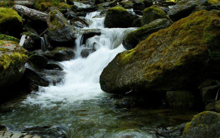
At the mid-way point, is O’Neil Creek camp, but from the trail, you’re unable to see what the sites look like. By our GPS, this is at the 6.9 mile mark, a little different from what the TOPO maps distance states…Another site, that we thought was of nice, was at the 10.1 mile mark, along a nice sandy beach. There are several sites here, and they were mostly full when we walked by, a testament to its popularity and an explanation of why there were so many cars in the parking lot. We also crossed over several small streams making their way down from the highlands above us, like Fire Creek, No Name Creek, and Pyrites creek. The latter two also had campsites situated near them.
“…old Maple trees dotting the red tinged grasses that swayed in unison in the breeze…”
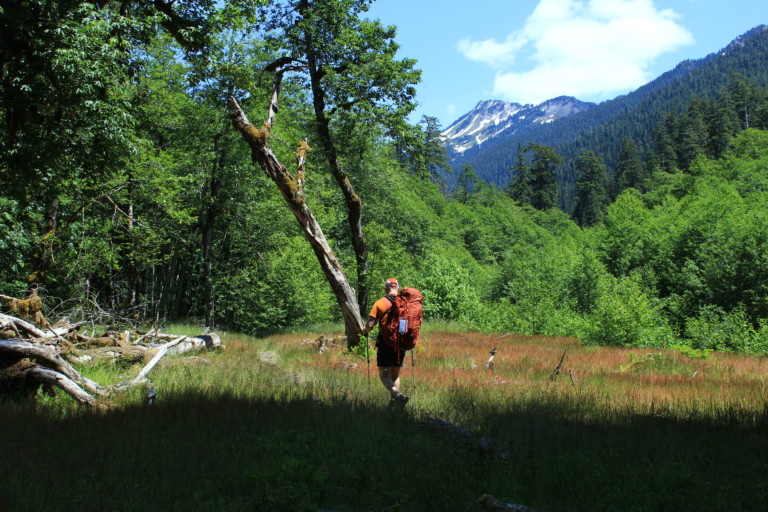
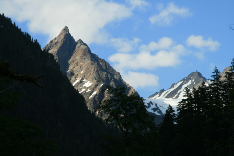
The further up the trail you get, you run into some anomalies you would not expect this far into the Olympics, like grasslands. Huge, open fields with large, old Maple trees dotting the red tinged grasses that swayed in unison in the breeze. We kept expecting to see large herds of deer and elk grazing in the fields. One of these smaller fields of grass appear shortly after the beach campsite, at 10.7 miles, and provides a foreground for your first glimpse of the peaks that surround the Enchanted Valley ahead, the snow covered flanks of White Mountain.
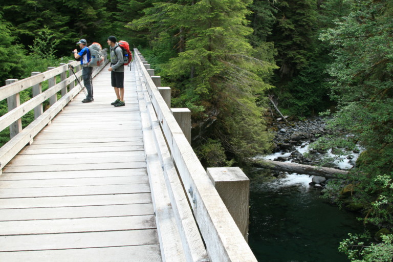
About a half mile before entering the valley where the chalet sits, you cross the Quinault a final time over a huge metal beam that spans the river, covered in wooden planks, what surely must have been a formidable task to install. It’s concreted in at both ends for a secure footing, but because the span is so wide, it sways slightly underfoot, giving you the impression that it is all made of wood.
“…It’s no wonder they named the place Enchanted Valley…”
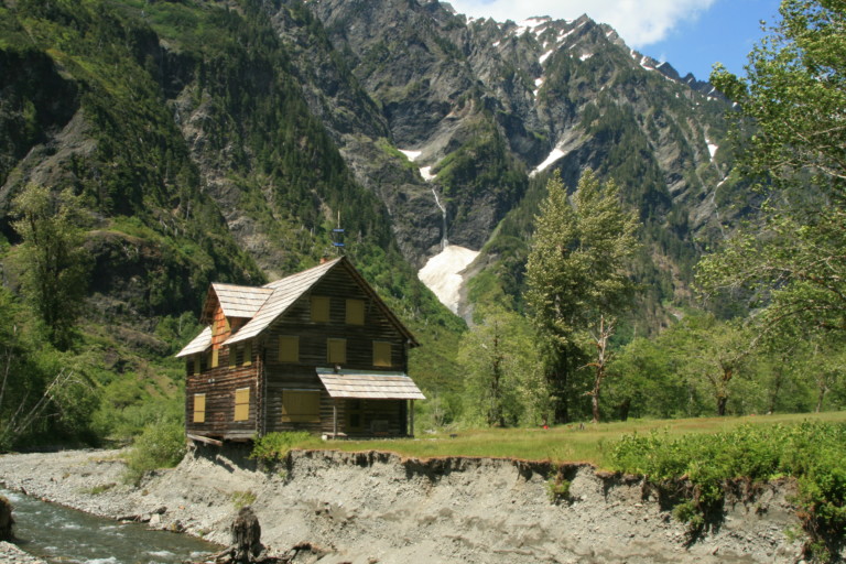
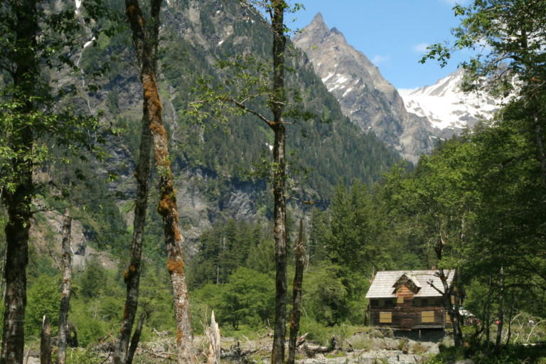
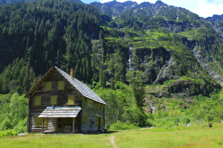
Finally, the chalet comes into view, in what must surely be a different view from decades past, for it now teeters on the newly created river bank, undercut by this year’s run-off. It’s an impressive sight, as this old wooden building stands boldly in a valley ringed by magnificent barren peaks, with long flowing waterfalls trailing off from the heights above. Snow still stands in the shaded clefts of the rock, helping to feed the water flow. After hiking for many hours in the trees, to come out into this open field surrounded by stark jagged peaks of rock rising over 1000ft above, is truly inspiring. It’s no wonder they named the place Enchanted Valley, for I’ve never seen a place such as this, as if conjured out of the imagination of J.R. Tolkien.
It looks as if a Boy Scout troop must have come up the night before, as there is a large group of maybe 15 to 20 of them, packed up, and getting ready to head back down the trail.Looking around, it’s not immediately clear where the designated sites are, so we wander through the valley, looking for a spot to pitch camp. Most of the good sites are taken, so we pick the spot in the open, near the chalet, with an established fire ring near the bank of the river. In our immediate foreground is the chalet, boarded up for safety reasons, as the river now threatens to sweep it away. Upon closer inspection of the chalet, etched in its foundation is the date 1930, and it still looks in good shape, except for the loss of ground underneath it.
“…but hopefully, the park service will be able to save this historic place by moving it back from the brink of disaster…”
It also sports a ranger station, complete with stove, and on the rooftop is something that looks like a dish, or solar array for comms and power. You used to be able to stay in the chalet, and I’ve talked to a guy that remembers doing it over 20 years ago, when he came with his family. We’re sorry we never got the chance, but hopefully, the park service will be able to save this historic place by moving it back from the brink of disaster, and per their website, that is an ongoing discussion.After setting up camp, and just sitting and relaxing for a bit, it’s now time to look for firewood. Spying a pile of downed branches we make short order in getting enough wood for the night time.
“…Lots of “whoooo!” later, and we’re clean…”

Water too, is a needed commodity, so we visit the river’s edge to fill up. Now, I don’t know about you, but after hiking for 14 miles in warm weather, I’m more than ready to get cleaned up, and in no time, we’re stripped down to our skivvies for a dip in the river. That first foot in the water tended to dampen our enthusiasm a bit, as bare feet became numb in seconds, the water was so cold…But, we found a small pool with a sandy bottom directly under a fallen tree, so it made it easy to hold onto the tree while bathing quickly in the river, without worrying about completely frozen limbs collapsing into the freezing waters. Lots of “whoooo!” later, we’re clean, and sitting out in the sun on warm rocks to beat back the threat of hypothermia…Ok, I might be exaggerating a bit, but man, that water was COLD!!!! Brisk, baby!
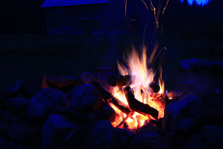
We did our best to photo document the area, and the chalet, craning our necks upwards as we followed the thin waterfalls uphill towards their source. There was no way to get the entire spectacle in one shot, so all we could do was focus on several spots that deserved attention.With full bellies after dinner, we started our campfire, and settled in for the night, making smores, and talking around the fire before turning in. A truly great night in the back country.