July 15-18, 2005
DAY 2. From trail jct #101 to Snowgrass Creek
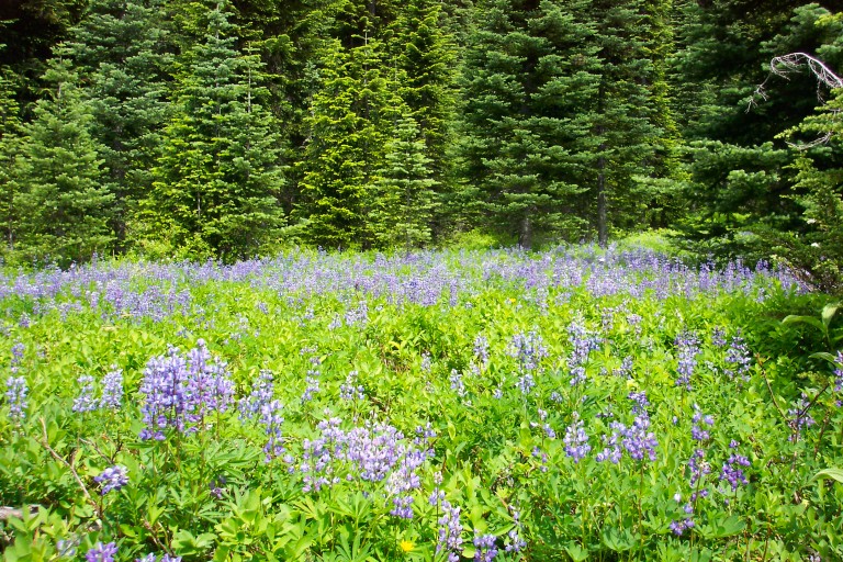
Lupine meadows
The next morning, we awake around 6:00am, and can hear an elk bugling. We can also hear light sprinkles on the tent, and worry that we may have to contend with getting wet…The skies are grey, with a low cloud cover, and it’s a little chilly. We break camp at 8:30am, keeping our eyes to the sky, trying to feel optimistic. Trail begins with a gradual uphill, not bad hiking, and the grey skies are starting to lift and break up some. It’s actually nice to have it a little cooler today, as we’ll be doing some uphill, and I’d rather do it in cool weather, than grind you into the ground heat.
Actually, in my instance, it’s more like melt you down into a little puddle, so that you can seep between the cracks in the parched ground! Hope that wasn’t too optimistic for you…Russ spots an elk, a cow, and as soon as she realizes that she’s been spotted by the humans, she bolts uphill…Sigh…Wish I had her energy to sprint uphill like that…We see lots and lots of elk sign, as many small trees are de-barked from the bulls sharpening their horns.
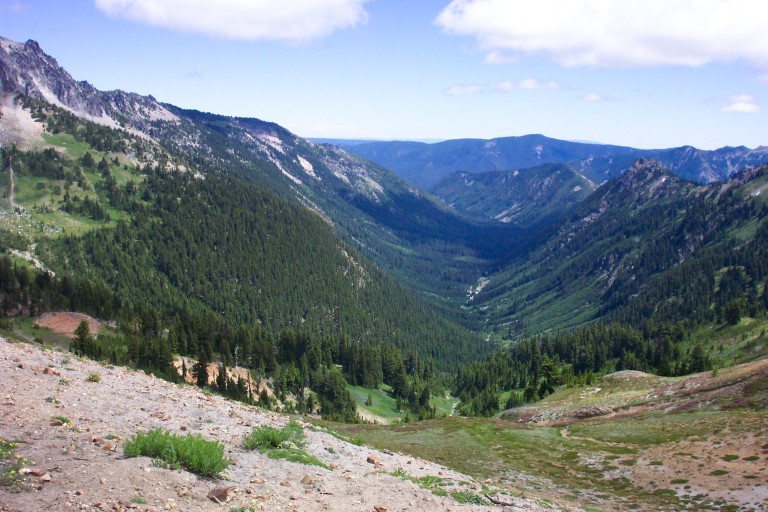
At this point, we are still side-hilling, and it gives us commanding views of the valley below us, lots of forest and meadow views, as well as a couple small lakes. As we near Nannie Ridge, some cool looking rock formations appear, just a small glimpse of what is to come, and above the trees on the ridgeline, you can see the top spires of Goat Rocks. By now, we are starting to see a few hikers…We pass two guys that had started in Canada three days before, and are planning on doing the whole PCT in 5 months. They said that they were headed for Timberline…Not in one day, obviously…Still, to do the whole PCT…Wow…And here, I thought doing the whole Wonderland was a big objective!!!

Walupt Creek Crossing
As we begin to approach Walupt Creek, we are besieged by the dazzling array of wildflowers, it’s a veritable riot of color!! These meadows, so far, have the most brilliant colors, as each different variety tries to outdo the other, by pumping up the color volume. It’s an “Ooh, Aah!” moment for me, as I feel obligated to stop and document the color explosion with my camera…By 11:30am, we reach Walupt creek. Yay!! Fresh clean drinking water! I dump out the “pond water” that I had before, to fill my bottles with nice, clean, cold, running, water…Ahhh…
It’s also very pretty here, a very scenic creek. Took several pictures. Here we also run into (ok, not “run into” as no one around here is running…This is walking at its best, man!) a couple of women and their dog. They ask us if we have any water purification tablets, as they seem to have misplaced theirs.
…The oldest woman seems to be in her late forties, early fifties maybe, and her companion doesn’t seem to be any older than 20. I notice that she has a blue glitter fingernail polish on, something that you would see a teen wear…
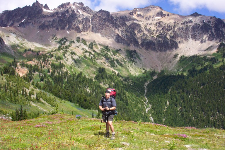
Goat Rocks views
We give them some, talk for a couple of minutes, and then we head out. The oldest woman seems to be in her late forties, early fifties maybe, and her companion doesn’t seem to be any older than 20. I notice that she has a blue glitter fingernail polish on, something that you would see a teen wear, I notice because it’s to her that I hand the purification tablets to…She never says a word, very quiet.
Around noon, we reach Sheep Lake, and continue on. Lots of meadows surround the lake. No views of the big mountains, as we are still under cloud cover. Close to 12:45pm, or so, we reach the spectacle of Goat Rocks…We finally crest a no-name ridge laying in next to Nannie Ridge, the trail just kind of pops up over a small ridge, around a copse of trees, and “Bam!”, it just hit’s you. You are standing on the edge of the Klickitat River valley, with the Goat Rocks on the opposite ridge, facing you, Gilbert Peak being the prominent peak here.
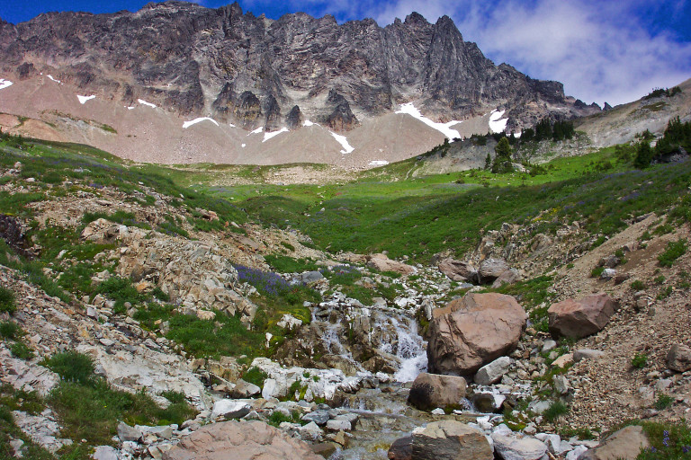
It is breathtaking…The ridge on our side is covered in bright red Indian Paintbrush, and small clumps of pink flowers, growing so thick as to give a pinkish to reddish hue to the surrounding landscape. Goat Rocks, in a word, is…Intense. The jagged peaks soar into the sky, trying to block out the sky, like ancient cathedral spires, they grow up and up…Against their massive bases, there is a scattering of snow fields, which feed the beginnings of the Klickitat River, which flows off to the east, through the Yakima Indian Reservation.
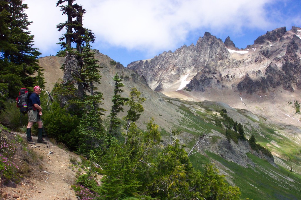
Trail to Cispus Pass
I wish I had a better command of the English language to adequately describe the beauty of the landscape, but I do not. I felt, as I stood there, very insignificant, like a mote of dust, next to these massive columns. But, I also felt uplifted, inspired, and excited about what I was seeing. Suddenly, the aches and pains of the trail were forgotten as I stood here on this ridge. The next 2 hours were to be filled with “big views”.
After several pictures, and time spent gawking, we continued along the ridge line, skirting the edge of the valley, and the ridge to our left was built mostly out of Andesite columns, volcanic lava flows that cooled in long columns, similar in appearance to a stack of new pencils, wrapped in bunches, and then these bunches stacked on top of and next to each other, a fascinating sight. Chunks of these columns have broken off over the centuries, and left a huge pile of scree to walk over.
Just think, from this high point, you can see the beginnings of an East side river, and a West side river.
After an hour, we reach Cispus Pass, high point on the PCT for Washington State, at 6400 ft. Another big view here, huge, actually, as it is doubly impressive as the last. From here, we can see to the west side, and the Cispus River basin. You can see the headwaters of the Cispus River, branches of it starting from the snowfields of Old Snowy, and the Northern most sections of the Goat Rocks. Just think, from this high point, you can see the beginnings of an East side river, and a West side river.
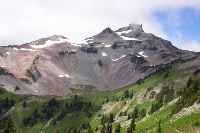
Old Snowy
I take as much video and pictures as I can, and part of me doesn’t want to leave, I could stay here for quite awhile, just taking it all in. Here on the west side, you can see the trail winding it’s way along the opposite side of the valley, as thin as a thread, and you can see that it crosses paths with a waterfall on the Cispus. The trail beckons, and we wind our way down from the pass…As we do, we are greeted by another surprise view, one not seen from the pass.
Klickitat River valley
The trail bends to the right, around a ridge, and heads back up to the beginning of the valley, and there, you see another incredible sight! It’s like staring at a smaller version of the Rocky Mountains! This is the Northern flank of the Goat Rocks, and they are just as magnificent as the other spires! Get some good pictures here, as well…The views just seem to keep coming! You end up running out of adjectives to describe! If one has been there, one knows how difficult it is to describe. We stop at the waterfall, and fill up. After being exposed to the sun for hours, the spray coming off of the falls is refreshing.
What would have wowed me on day 1, simply gets an exhausted yawn now. It’s like eating your favorite ice cream for three days in a row, until you’re tired of it, and don’t want anymore…Well, kind of like that, anyway…

Goat Rocks
Hiking becomes easier from here, as we slowly descend. I no longer look as longingly at the views of the valley as I did earlier, it’s as if I have reached a visual critical overload, and my brain simply cannot process all of the input anymore…What would have wowed me on day 1, simply gets an exhausted yawn now. It’s like eating your favorite ice cream for three days in a row, until you’re tired of it, and don’t want anymore…Well, kind of like that, anyway…
By now, my feet are getting sore, and I don’t know it yet, but I am developing a rather large blister on my heel, which I won’t discover until we get to camp. I thought I was just developing a “hot spot”, as it feels similar to previous experiences. Russ, too, is experiencing some blistering, on his big toes. He gets a gnarly one, that starts on the bottom, and actually starts to come around to the top of his toe!!! He remains positive, however, and it doesn’t seem to bother him too much.
We reach the turn-off for trail 97 around 3:30pm, and we say good-bye to the PCT. It’s been an awesome trail, and I feel a bit sad to be leaving it. On to Snowgrass
Beginnings of Cispus River
Flats, our destination for tonight. We travel through more meadows, interspersed with alpine firs, and lots more lupine. It seems wherever there is an open patch of ground, there is lupine, sometimes growing so dense, that a purple patch can be seen on the ground from miles away. There’s lot’s of fresh water here, several little rivulets running through the meadows, and we come to a large stream that appears on the map as a tributary to the Cispus river, which we will call Snowgrass creek.
Very scenic little stream, rushing down over moss covered rocks, and on the opposite bank sitting about 5 feet above the water, is a nice level spot under some large trees. It’s an ideal spot, and we decide to camp here for the night. It’s at this point, that I discover that I’ve lost my nice DeerSlayer knife!!! Oh, woe is me! I’ve had that knife since 1981!!! Very depressing, and worse still, we now have no knife. I mean, what am I to do if I break my pencil lead? Gnaw on the end like some kind of woodchuck? Oh, the horror…Sigh…I’ll miss that knife. I can only hope that someone who really needs one, will find it.
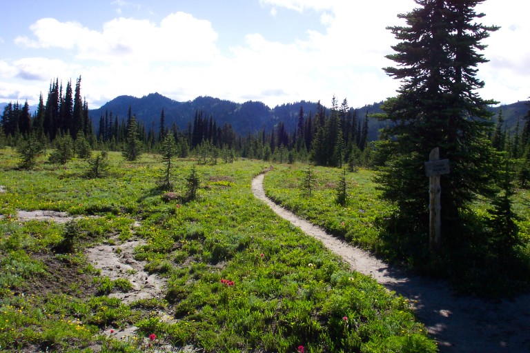
Snowgrass Flats
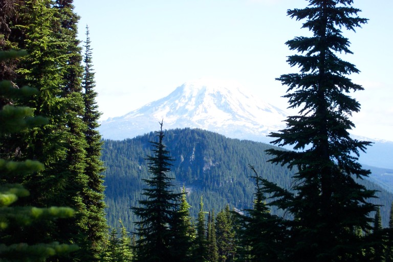
Mt. Adams
We reach this spot around 4:20pm, and after setting up camp, decide to hike up the hill to Alpine camp, and a higher spot of Snowgrass flats. It’s also very beautiful up here, too, alpine trees and meadows spread out, with several nice campspots. Good views of Mount Adams. Very scenic area, Russ and I decide that someday it would be nice to come back and do more exploring.
Once back in camp, we take stock of our feet. Russ now has 3 blisters on his feet, and I discover that I’ve got a good one on the back of my heel. We patch them up with moleskin, and hope for the best. After dinner, we’re in bed by 9:00pm, and play dice again for about an hour and a half before turning in…Say, what’s the final score, Russ?
Gets cold tonight, I have to get up and put on my thermals, and really zip myself up in the bag. I notice in the morning, that Russ is also similarly zipped in. I guess that can be expected, as we’re at 5800 feet here…
2005-07-15