Day 2
12.25 miles, 3677ft gain/3680ft loss.
You know, after writing down just how much gain/loss there was on this trail, I don’t feel nearly as bad as I originally did after our first day’s hike, as I was tired and beat up. That’s the nice thing about the Garmin, is that it records ALL of the ups/downs of the trail, and puts them in a nice, tidy sum for you to see at the end of the day.
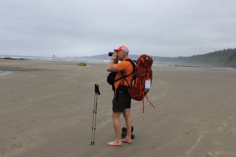
The weather looks as if it’s going to cooperate and we are happy for that, as we start under cloudy conditions, with hints of blue sky poking through once in a while. Right at the beginning, you cross the Ozette River over a bridge as it dumps into the Lake, and start hiking through varied old growth timber, marsh, and open fields all the way to the beach, at 3.4 miles. To cover some of the marshy areas, you will walk across one of the longest sections of boardwalk that I’ve ever encountered on a trail, some built with long sections of steps up and down.
“…They hardly paid us any attention…”

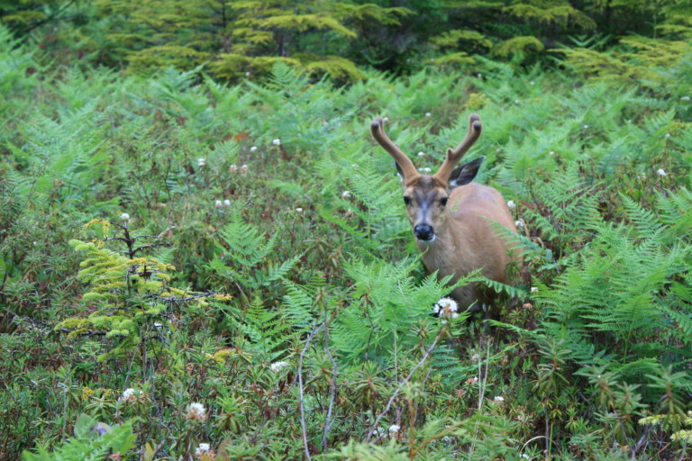
During one of the sections where you break out into clearing, we happened across a group of 3 bucks nonchalantly foraging, allowing us to get within 8 feet of them. They hardly paid us any attention, intent more on feeding than being concerned about humans. Since it’s mostly a flat jaunt here from the lake to the beach, we are able to cover the 3.4 miles to the beach in just a little over an hour. As we drop down to the beach, we’re relieved to see just how far out the low tide extends, knowing that our first obstacle to cross is the Ozette River, and with the tide that far out, crossing it should be no problem.

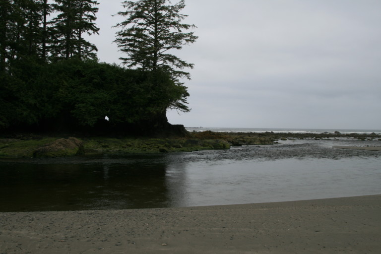
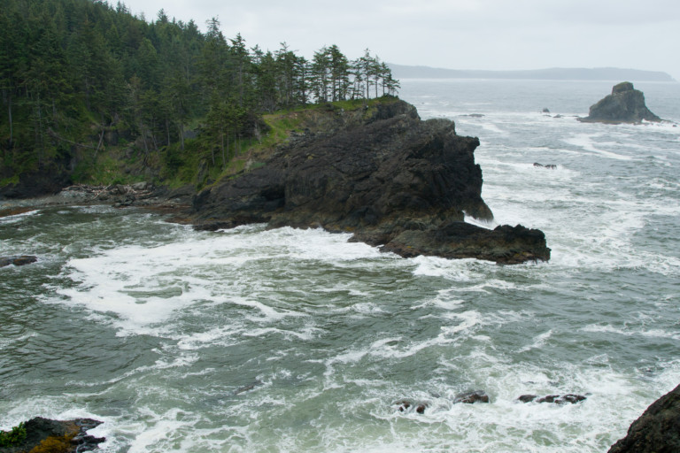
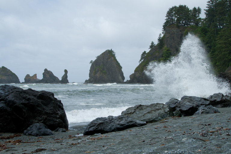
In the distance, across wide tide flats, we can see the towering rock formations of Ozette Island, and in the trees capping them, we can hear the screech of Bald Eagles over the swirling sounds of wind, gulls, and surf. Heading north, the beach is sandy and flat here at the high tide point, but the extreme low tide has exposed the seaweed covered rocks further out. We make quick time around Cape Alava and Tskawahyah Rocks to a short overland crossing that gets you up and over this point of land before reaching the Ozette River, at 5.58 miles. We were relieved to see that this crossing would be no problem since the tide was still way out, as we reached the river at around 8:30am. So, peeling off our boots, we made the quick crossing to the opposite bank. It was a little rocky underfoot, but not too bad, the rocks weren’t sharp, and the dry sand on the other side felt good in our bare feet.
“… as if the rocks themselves are trying to mimic the ocean waves…”
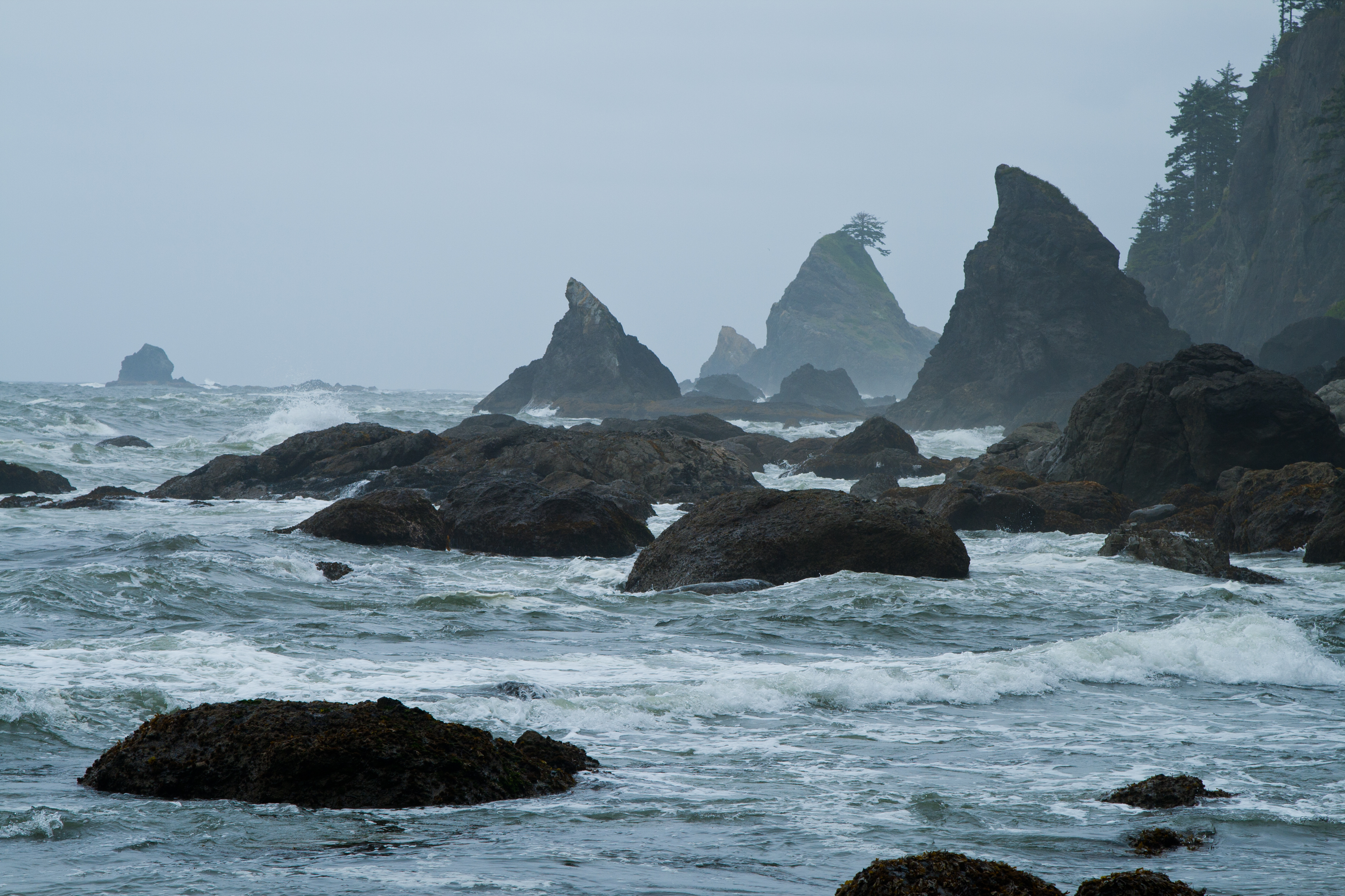
Re-booting, we continue north along the coast, and in the distance we can see two shark fin shaped rocks, which I believe are called Father and Son, off the next point of land that we have to get around. For now, the beach ahead looks like flat sand, but looks can be deceiving, for there are stretches where the beach is nothing but large, round, washed rock, arranged like fish scales from the advancing/retreating tides, washing it up in piles, as if the rocks themselves are trying to mimic the ocean waves. Very Feng Shui…
We pass Seafield Creek, at mile 7.8, where we had hoped to camp for the night, but were unable to because others had already reserved them, and take a quick look around. The one site that we see is quite small, up off the beach in the trees, but at least there is fresh water here, we didn’t bother to look for the other of the two sites available here, as we need to push on, trying to beat the tides. It’s coming back in, and we want to be sure to try and make it to Shi-Shi before getting cut off.
“…so we make a mad dash around the point…”

Nearing the point of land that juts out towards the Father/son rocks, is another tall island of rock, and as we approach it, the waves are really starting to come in now, grasping at the jumbled boulders that now lay around this point, a beach is no longer visible. We can’t see around this obstacle, and do not see another overland route here, so we make a mad dash around the point, jumping from boulder to boulder with our full packs on. We can both feel a little adrenalin rush, as we’re not sure what lies around the point, and we don’t want to get cut off here, not wanting to back track with the ocean grabbing at the rocks like a bear trying to reach a stuff sack just out of reach.
“…when we saw a thin figure come from the tree line…”
Finally, we could see a spit of sand around this point, and were relieved when we finally reached it, a small, crescent shaped beach tucked in between two outcroppings of land, creating a small cove here between the rocky shoreline, maybe all of 150 feet long. This was at the 9.3 mile mark. We had no sooner set foot on this small beach, when we saw a thin figure come from the tree line at the edge of the beach.
As she got closer, we could make out more details, like the moss stuck to her shoulder, twigs sticking out of her hair, and sweat covering her face and brow. Even her glasses were slightly off-kilter, pitched to one side as if they were sizing us up, like the inquisitive gaze a dog will sometimes give you if he’s not quite sure of what your intent is….
“Hi!” she said, obviously relieved to see someone. “Did you just come around that point?”
“Yep! And, if you hurry, you probably have about 20 minutes or so to get around it, if you leave now.”
Then, she told us that she had been up the rope behind her twice, and somehow got turned around trying to find an overland route around the point we just came. Well, that explains the hubris attached to her in varying places, but…Neither Greg nor I said it, but we were thinking, “Uh…How do you get turned around along the ocean, if the waters on your right shoulder, land on your left?”
Questions ensued, and we found out she was from Oakland. She was trying to get to Seafield Creek camp, so she was one of the campers that must have beaten us out by reservation.We bid her farewell, as we too, were fighting the tides. She told us she was just going to wait it out there, until the tide went back out.
“…Sure hope that woman doesn’t end up in the news…”
Now, that rope that she had just been up twice? Well, let me tell you, not what I had expected here along this part of the coast. We have used the ropes several times at different locations along the coast, and there was barely a reason to use them, as the trail was just slightly steep. This time, it was truly a matter of pulling your bulk up the first 10 feet or so, just to get to a point where you could actually walk, the rope here was a necessity! I couldn’t believe it; I was actually gassed by the time I got to the top of the headland! As we stood atop the ridge, all I could do was laugh at the last 10 minutes experience…”Man, that rope was not what I expected at all”, I half laughed, gasped at Greg after he reached me. “Sure hope that woman doesn’t end up in the news….”
“…like old world schooners, masts straining against a fierce wind…”
Then, back down the other side, and we were again confronted with another small, rocky beach with great views of the rocky outcroppings facing the full onslaught of the Pacific Ocean, like old world schooners, masts straining against a fierce wind.
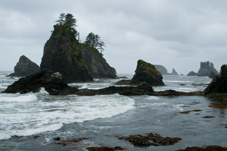
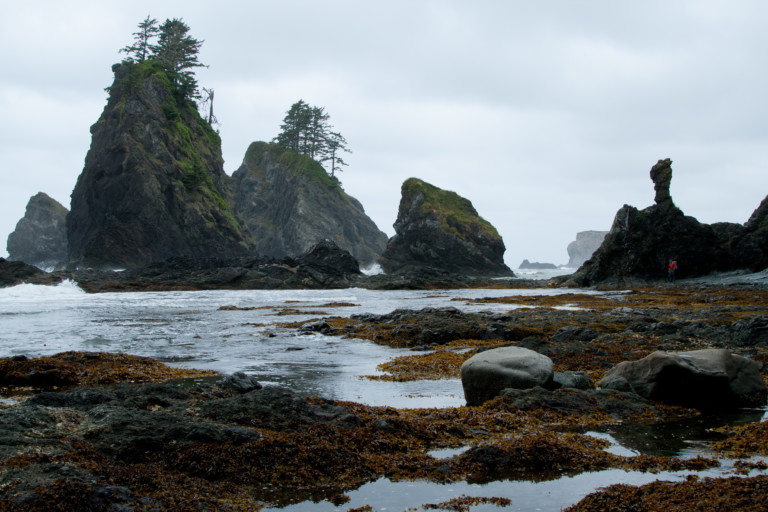
Now, we approach the longest stretch of trail at 9.7 miles that goes overland on high bluffs. It’s a steep ascent up about 350ft in .2 miles. Once you’re on top, it’s not bad, but the climb up is steep and once again surprising. There are several view points along the way that you don’t want to miss, small open areas that let you peer back south the way that you came, really giving you a good perspective on how many pillars of rock jut out into the ocean, like a mini mountain range.
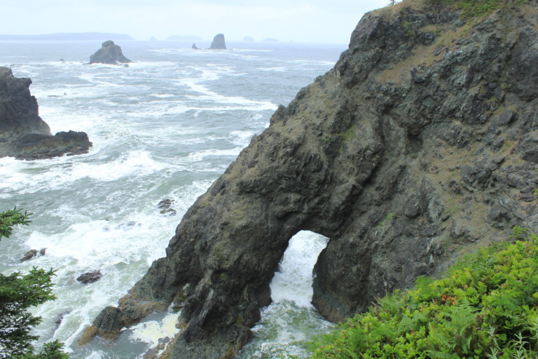
Then, as quickly as you ascended this point, you drop back down, and then quickly back up to round a secluded small beach that looks like a pirate’s cove. The only thing missing is Blackbeard’s ship anchored just beyond the rocks. This is at the 10.9 mile mark, the point of land that cleaves the waters just before reaching Point of the Arches. The steep rocks crowd the ocean into a small inlet. There is a bridge of land that takes you out to the top of the foremost rock, and at its base is a large arch, where the waters froth as they bully their way through. Be sure to stop here and take pics…
“…but time was not our ally now…”
As we drop down onto our final small beach, right before Point of the Arches, we’re a little concerned that the tides might have finally caught us. I hated hurrying through this section, as it really begged to be explored, but time was not our ally now. Reaching the point, our worst fears were realized, there was no way we were getting around, unless we were going to swim…Oh, well…We came so close! Shi-Shi beach was just around the corner, but right now, it might as well have been on the moon.
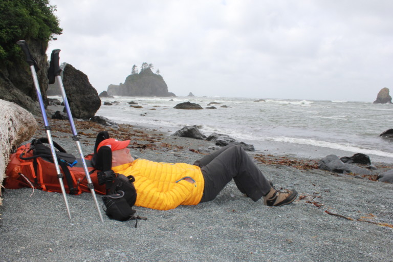
We walked back to the high point on this little beach, and set down and enjoyed our surroundings. The grey skies that we had been walking under all day actually broke up a little, and allowed the first sunbreaks, making the ocean and wet rocks glisten. Here on this high point of beach tucked up next to the wall of rock was a large flat drift log, so wide and flat that we could lay on it. The beach here was more very small grey pebbles, like beads. And, one thing we noticed pretty quickly was that they were warm, having absorbed the rare glimpses of sun that touched them. Nice! After something to eat, and drink, and having several hours to kill, it was a great opportunity to get comfortable on the welcome warm beach, and grab some Z’s.Finally, around 4:30, the tide receded enough that we could make our way around the point.
“…Who would imagine that inland it was raining as if it needed to catch up with some target or goal…”
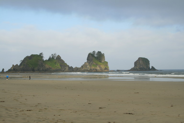
Now, we were finally on Shi-Shi beach. It seemed to be a long, wide sandy beach with little distinguishing features breaking up the monotony of sand. Against the tree line near the first small stream, we found a place of dry sand behind a huge driftwood log that would act as our windbreak, we hoped. The wind was still blowing SW, so we placed our tents up against this log, and started looking for driftwood that we could burn. All the time, we kept a wary eye on the sky, as the grey clouds now started turning dark, and it seemed to us, to threaten rain. So far, we had been very fortunate, as we were still dry. Another unusual thing about this hike was that we had 4G coverage here, so being in contact with family on a back pack trip seemed odd. That’s when we heard that at home, it was pouring, and they were sure that we were suffering a similar fate. Nope! Who would imagine that inland it was raining as if it needed to catch up with some target or goal, when so far, we stayed dry on the coast.
Wood collected, we started dinner, and then here it came. Nothing too bad, but it was a slight drizzle, occasionally with heavier showers. Still, by now we had a fire going, our tents up, and tarp to prepare dinner under, so we were set.After everything was stowed after dinner, we set around the fire making s’mores, thanks to Greg!
About 9:30pm, we see a group of three stragglers come in from the same direction we had come, and start looking for a spot to set up here along the driftwood shores. They start to set up about 15 feet or so from our tents, and we look at each other…This long wide beach, and they’re gonna set up that close? But, they move further south so now they are about 30 or 40 feet away. Much better.
“…Funny, seems that we must have built a pretty hot fire…”
We had sometime during the day propped a driftwood log between the windbreak log, and a stump that was about 3 feet off the ground and near the fire, but not over it. Funny, seems that we must have built a pretty hot fire, for we noticed over time that the log was starting to smolder…
Still, it seemed too far away to really be affected by the fire, so we didn’t pay that much attention to it, and instead went back to warming up our insides with a little nip of Fireball, until suddenly, the log just burst into flames, as if we had doused it with kerosene!
As I’m sitting there watching, it suddenly seemed a most excellent idea to do a fire walk!
“Hey, Greg, watch this!” I jump up, clamber up on the windbreak, and then start walking out across the still burning log. Again, it all seemed like a good idea, until it started to roll from under foot….Not really wanting to end up in the fire, I managed to bail off the other side, into the sand…
By now the fire has burned itself out on the log, and another try no longer seems necessary, so I resume my place by the fire.The drizzle continues on and off as we sit by the fire, and now it’s time to turn in.