Ranking: 4/5 We were looking for a shorter way in to Larch Lake than the traditional way up Chiwaukum Creek, and this seemed to fit the bill, only 8 miles over the pass, which cuts off almost 5 miles from the other direction. Getting up and over Dead Horse pass is no easy feat, but the views from the pass down to the lakes and north towards Glacier Peak are definitely worthy. Once at the lakes, there is much to see and do. Go fishing, climb some of peaks here in the Chiwaukum Mountains, or stroll through this beautiful larch filled basin sightseeing and taking pictures. There are definitely few places like this in the Pacific Northwest, and its remoteness adds to it’s charm. Camp spots are scattered around the lake, and might take a bit to find a good one as there really are no marked or signed trails around the lakeshore. Bugs are bad in the summer.
Difficulty: 7/10.Getting to Dead Horse pass is challenging, not for the novice, but those with solid off trail route finding will have no difficulty finding their way up and over the pass. Its a good scramble up and over, and the terrain is steep and littered with loose rock, and the total elevation gain for the day is over 4500ft! Snow fields on the Cup Lake side usually stay through the summer in places. Once to the shores of Cup Lake, you are still left on your own navigation, as there are no established trails to the meadows that surround Larch Lake. There is really only one good established campsite near the shores of Larch, the others are up to your discretion, bare or durable surfaces are scattered around, you will have to look for them, as there are no signed trails around the lake. This only adds to its rugged beauty, so be sure and follow LNT principles. Did I mention how bad the bugs are in the summer? Load up with repellant and a bug screen, or you will find yourself on the menu. Horse flies are the absolute worse I have ever seen…
Getting there: Take I-90E towards Ellensburg, and just past the town of Cle Elum, take exit 85 for WA 970N towards Wenatchee, then turn left over the overpass that crosses I-90 to the junction with WA 970N. Turn right, and drive 9.9 miles on WA 970N, where it will then merge with US 97N, and stay on US 97N for 35.2 miles to the end, where it “T’s”. Now, you will turn left up the ramp and join US 2W, and follow it 4 miles into the town of Leavenworth. At 9th street ( a major cross street in downtown Leavenworth) re-set your trip odometer, and continue following US 2W through town 21.6 miles, and turn left onto White Pine Road, #6950. NOTE: Be careful here! Just before you get to your left turn, you will see Ray Rock Springs Custom Knives on the right, a red building, and just after that, you will come to a passing lane! You need to be in the left lane, (the passing lane) to make your left turn, so be careful here!!! People drive fast on this highway, and are looking to pass, and may not notice that you are trying to turn left, so please be cautious!!! Once you’ve safely turned left, go 2.1 miles on a dirt/gravel road, past the Baptist camp, to a Y, and stay left, on White Pine Rd #6950 to the end, at 3.9 miles total. Maps: Green trails map #145 Wenatchee Lake, and #177 Chiwaukum Mts. Or, create your own with Topo.com. Permits: You won’t need a NW forest pass to park here, but we still brought ours just in case…You will need to self register at the trailhead..
Another great weekend to hike!!! We are going to get all of our prescribed 5 hikes in, before the summer sun ends!!! I can’t believe our luck, and Dan and I head out on Friday at dark thirty, to get a good start, not wanting to parboil in the afternoon sun along ridgeline, as it’s supposed to get hot east of the mountains again.
NOTE: I added some fall pictures from our hike we would take 3 weeks later, as there were just so many that I wanted to share, not enough from the summer hike to fill the pages here…
Day 1
8.2 miles, 4555 gain/1285 loss. We reach the White Pine Creek Trailhead, #1582, at around 8:00am, after 4 hours on the road, and are ready to go by 8:20. That is, if you discount the fact that David got about 200 yards down the trail before realizing he had forgotten a key piece of equipment. His lid was still in the car, so we returned to get it, knowing I would need it once the sun was directly overhead…Hat in place, we begin our trek on a well maintained trail, that begins under forest canopy, so the tread is easy on the feet, consisting of mostly dirt and duff. It’s an easy trail, mostly flat, and, occasionally, for the first mile, you would get some views of nearby Whitepine Creek.
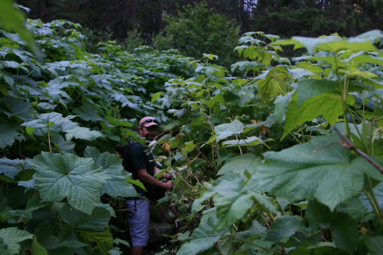
Dan almost invisible in the deep brush we encountered.
Flower filled meadow on the way up to Dead Horse Pass
“…one of the “conditions” noted was the fact that the trail was “brushy in places”. Yeah. And my 15 year old lawnmower has only been slightly used…”
It usually remained hidden, only giving away its position by the constant rushing of water over rock that would carry through the forest. All seemed to go well, until we ran into one of several clearings that allowed brush to spring up, as if the forest did not want any voids, filling the gap with greenery that would certainly choke out the trail if left unchecked. Before we left the trailhead, we read the posted trail conditions, and one of the “conditions” noted was the fact that the trail was “brushy in places”. Yeah. And my 15 year old lawnmower has only been slightly used…At one particular creek crossing, about 1.6 miles in, the Thimbleberries were nearly 10 feet high, and I felt as if a machete were more appropriate than our trekking poles.
Interesting rock formations…And Dan…
We passed several clearings that were chocked with the stuff, occasionally hiding in their velvety leaves were not so subtle Devils Club. If you were unlucky enough to stumble into one of these, it would definitely get your attention, the thorns would do their best to pierce hide and gear.
During each of these forays into minor jungles, Dan would cry out, “Thanks, Gregoire!” due to the trail maintenance funds being cut…The trail continued with this pattern through otherwise well maintained trail over easy terrain, until we reached the junction with Wild Horse Trail #1592 at 2.5 miles in. Here, we veered left to follow the Wild Horse Trail, uphill…All uphill, for the next 2.5 miles. The further up the trail we would go, the path started getting rockier, and the forest became more arid, now including pine among the fir, hemlock, and diminishing cedars. With less and less brush, and more elevation gain, we could see across the Wild Horse and White Pine creek drainages SW to Big Jim and Arrowhead mountains, and the crags of Bulls Tooth, further west.
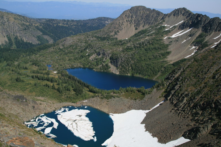
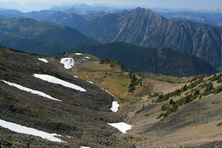
Larch Lake far below, with Cup Lake right below us
I had planned this route in mid April to go up the other side of the Chiwaukum Mountains, that now lie to our east, up the Chiwaukum Creek trail to Larch Lake, but we made last minute changes due to the fact that it was going to be a long slog, over 10 miles, with a group that already had some blistered feet, so the changes were made in order to find a shorter way in. This way, according to my quick route edits, would take off over 3 miles, and should get us to our destination in 7! That was the plan, anyway…
“…Google Earth made it seem that way would have less climbing steep ravines and gullies. More on that assumption later…”
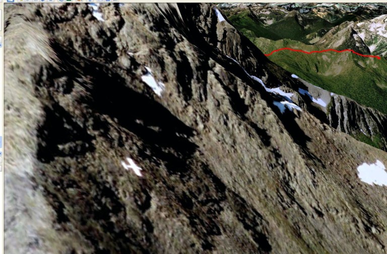
Picture from Google Earth, making it look as if there were a plane here…
Dan and I reached the first of two routes that I had mapped, that would take us overland on a scramble to the top of Dead Horse Pass, and, when we reached the 5 mile mark, there, to my astonishment, was a beaten foot path off the established trail, leading uphill! I had missed the exact mark by only 10 feet, planning from home. Not knowing exactly what the terrain had in store for us, I had planned two routes up to Dead Horse Pass, hoping that once we got here, we could make a better informed
The bench we crossed before scrambling up and over the pass.
decision, but the trees were still too dense for us to see the ridgeline beyond.…We decided to go to the next planned route further on, as the topo map, and Google Earth made it seem that way would have less climbing steep ravines and gullies. More on that assumption later…So, at the next prescribed route change, we left the trail and headed uphill through scrub brush and trees, looking for the least resistance through the stuff. This brought us to the leading edge of a ridge that was nothing but loose talus, overgrown with low growing brush and shrubbery. Once we reached the top of this small ridge, the trees continued to grow together closely enough to keep us guessing as to the easiest way through them all along the ridge line. At least the scramble over loose rock was behind us…
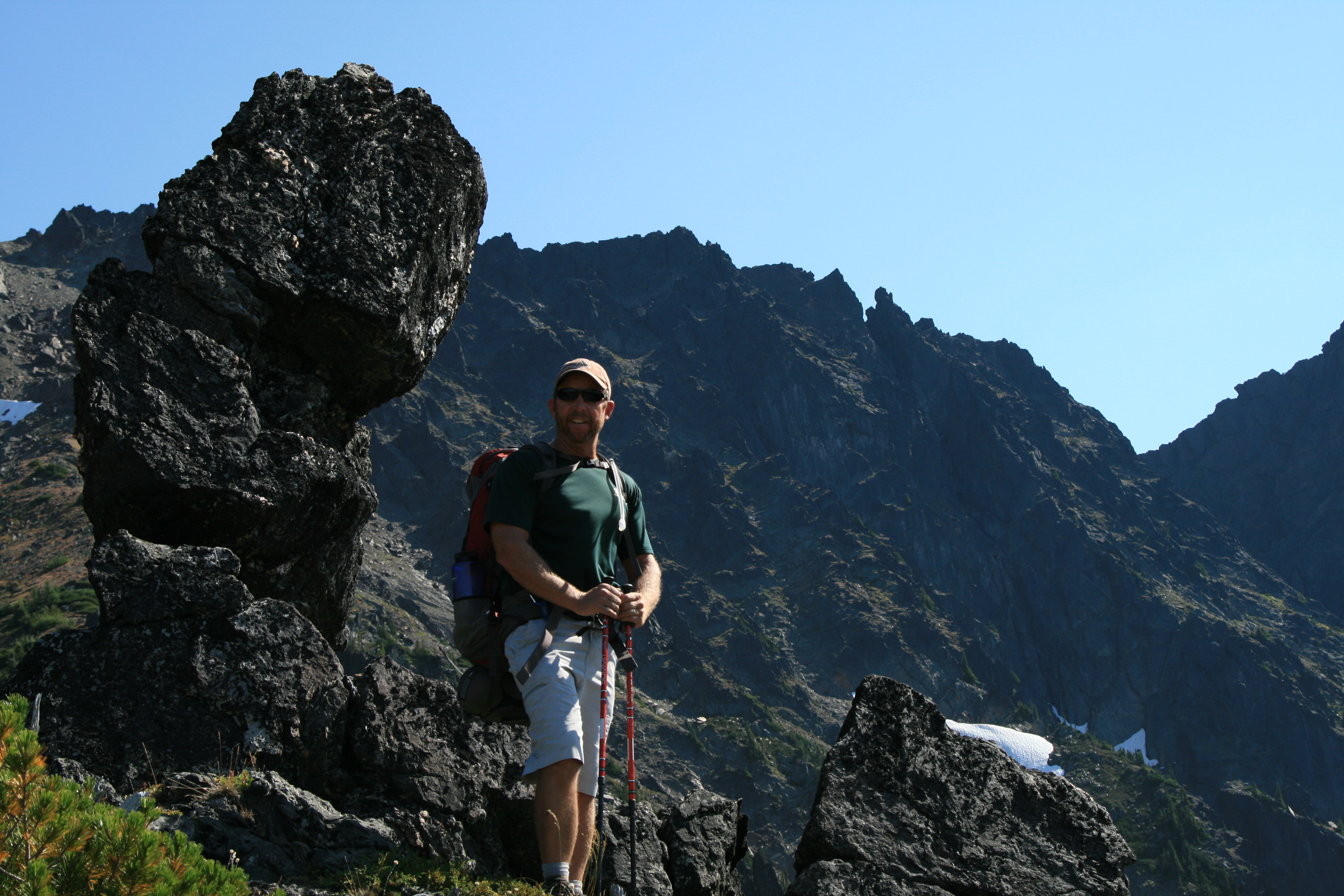
Dan at the top of Dead Horse Pass, with the peak? register..
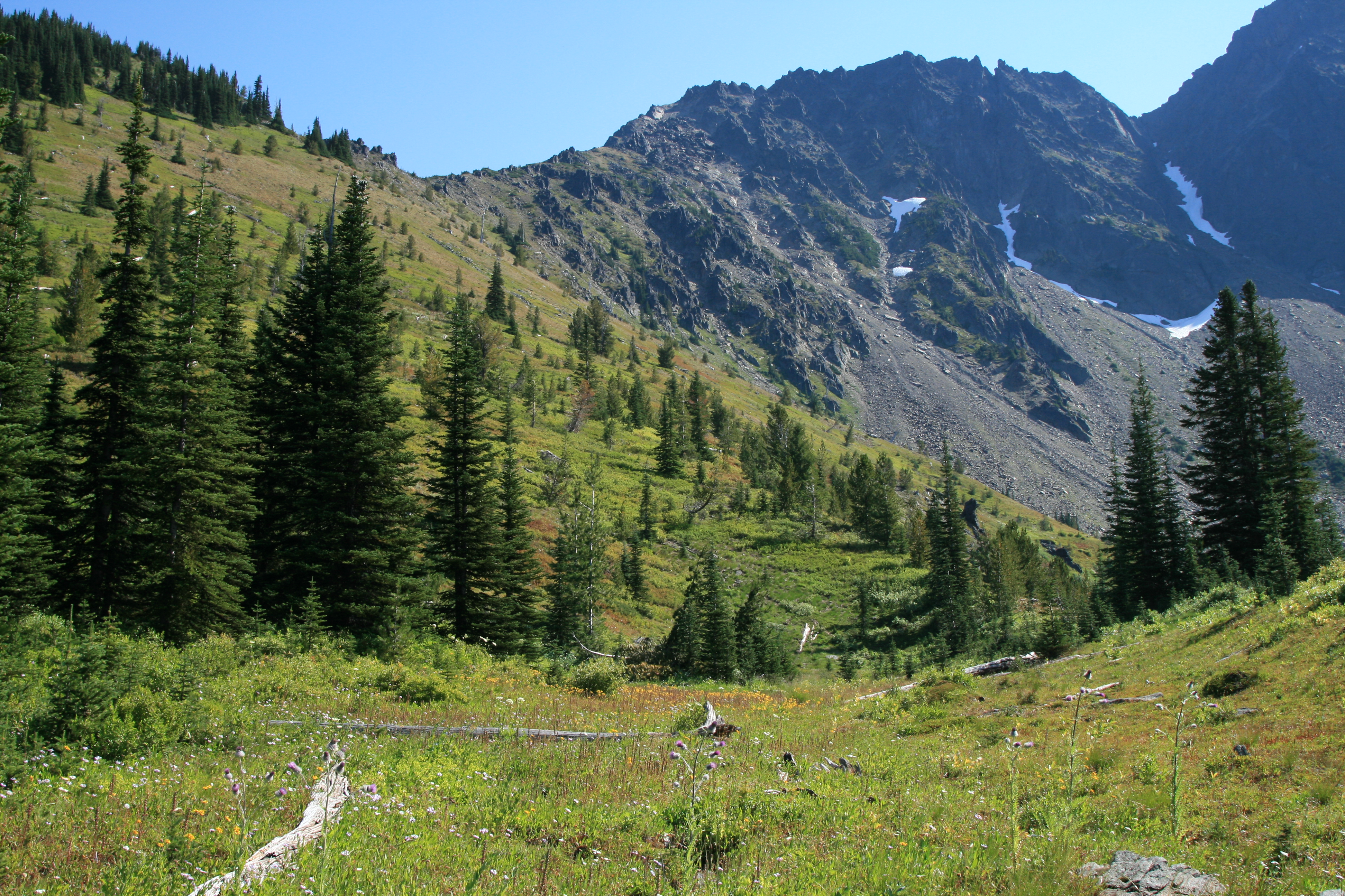
We finally entered a small meadow, covered in grass with a few flowers still blooming, and it was from this pocket meadow, that we could see the task before us more clearly. The way was inclined for several hundred yards straight up, with small hillocks of huckleberry, heather, brush and grass clumps, helping to hold the rock and soil in position. The nice thing about this was the fact that the small outcroppings of grass provided a flat foothold for us to side hill our way up, zig-zagging back and forth up the ridge to avoid gassing ourselves in a straight upward slog. We reached a small bench that was flat, its edges formed by the rocky ridgeline of the Chiwaukum mountains ahead, and the drop off of the ridgeline as it headed downhill, making a small flat spot here covered in grass, with a stagnant pool of water. A small oasis here amidst the rock. The slight breeze that blew here helped to keep the bugs at bay, as horse flies had been feasting on me to this point, leaving several little blood trails where they had opened up my skin….
“…and the top of the ridge looked like a toothy grin; that is, after a baseball bat had knocked out about half the teeth, shattering the rest…”
Dan heading down to Cup Lake, from Dead Horse Pass
The bench made a great viewing platform, to look across at the distant snow covered peaks of Mt. Daniel, and the closer spires of Bulls Tooth, and north to a multitude of ice capped peaks in the North Cascades. The bowl looked as if we were looking up from the floor of some long extinct volcano, and the top of the ridge looked like a toothy grin; that is, after a baseball bat had knocked out about half the teeth, shattering the rest. All the slopes here were steep, in places it looked like avalanches of large boulders had slid down to the small bench floor, as the upper reaches of the mountain ridge had collapsed, and in other places the grass and low growing ground cover had established beach heads in the loose dirt, rock and sand, growing uphill in a slow motion wave, like a painters brush stroke. It looked as if the shortest distance for us would be to keep to the right of the bowl, and side hill across to what appeared the low point of the ridge above us, near some monolithic rocks sticking up, reminding me of broken stone monuments one might see at an old Inca ruin.
“…I’m sure that you’ll notice all references remind me of food…I was starving by now…
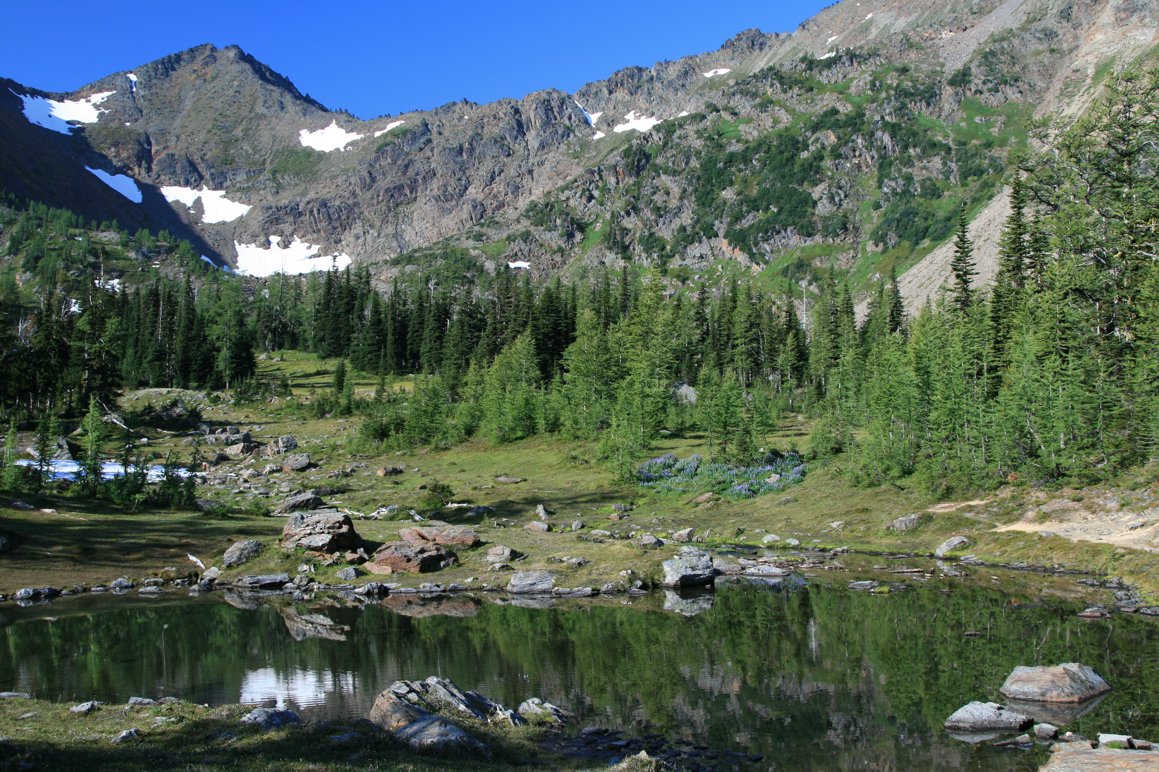
Small pool near our campsite, reflecting the Chiwaukum Mt. Range
Picking our way carefully across loose rocks and boulders, we make it to the rock sentinels that guard the top of the ridge, and look down into the valley below us. Cup Lake lies at the bottom of the steep cliff run out; half covered in chunks of white ice, the shadowed edge of the lake against the slope we are standing on is firmly entrenched in a white snow field. Further beyond Cup Lake, and downhill, is Larch Lake, surrounded in alpine firs and its namesake trees. Large grassy meadows are along the north and northwest shores, and the eastern side meets the rock cliffs that form the other side of the valley. Most of the rock here is different than the white and stark granite that is seen in other reaches of the Alpine Lakes Wilderness, the rock here is Schist, with white veins of quartz running through the reddish color of the rock, creating a look that reminds me of marbled cake! (I’m sure that you’ll notice all references remind me of food…I was starving by now…)
Looking straight down from our perch here, it was clear we weren’t going down this way, as the rock was a sheer drop at least 15 feet, before continuing its headlong descent to the icy shores of Cup Lake. Here’s the “More on that Later” section…I use Google Earth as a tool to see what the trail, terrain, and elevation will look like before we visit an area, and over the years, it has gotten increasingly better, to the point that trees with shadows now show up, as do the trails. It’s an amazing tool, one that gives you a 3D perspective unmatched by any current map. Having said that, there are still some drawbacks to it, namely, in how the software interprets the picture, and then overlays it on a 3D map…From home, I thought we would see bare granite walls leading from the top of Big Chiwaukum Mt, down to Cup Lake. Not so. It was more loose schist, forming long scree and talus run outs that would not be conducive to travel…And, there is a cool little glitch just near the top of the ridge line here that shows a small plane, but, again, the software flattens it against the mountainside, making it look as if it had landed perfectly on the side of the mountain, or worse…
“…Stopping to take pictures, I noticed a peak register poking out of a cairn, so we signed it; I was very surprised to see it here in a pass…”
Lupine filled meadows
Also, from our current perch, it was clear we were going to have to find another way down, so we followed the ridge further north, until we came to a cleft in the rock. “Hey, I see some footprints!” There was a faint trail of maybe 3 or 4 sets of boot prints in the dirt here, a good sign. Sure enough, when we reached the cleft of rock, there were a couple cairns, and a visible climber’s path leading down into the lakes basin! Still steep, about 1200ft of elevation loss in a mile, but it was clear to see that it was doable. Stopping to take pictures, I noticed a peak register poking out of a cairn, so we signed it; I was very surprised to see it here in a pass.
“There, we came through Dead Horse Pass.”
Big Chiwaukum in the distance, Dead Horse Pass is notch to the right
Dan led our downward descent, over loose rock and snow fields until we reached a small ridge dotted with shrubbery and small junipers that led down to the outlet of Cup Lake. We crossed the outlet, and continued following a faint path among the boulders and now Larch trees until we reached the meadows we could see from up above. It seemed odd that there was no defined trail leading you across these pristine meadows to the shores of Larch Lake, we could not find one. Tired, and just wanting to find a place to drop our packs and claim as our own, we hurried on weary legs along the shore until we found a spot that would work. Near the outlet of Larch Lake, we happened on a man and woman, and they asked us where we came from, and we turned and pointed up to the notch. “There, we came through Dead Horse Pass.” Which garnered a curious look. We asked if there were any sites farther on, and they said they hadn’t seen any. Thanking them, we moved on, and within minutes found a bare spot that looked as if it would work, near a snow field. Dumped our packs, and just enjoyed having the weight off our backs for a few minutes, before motivating ourselves to do anything else. It was now 4 o’clock, we had been on the trail for 9 hours.
“…The larch trees, with their Dr. Suess whimsy, and the blended meadows and rock all lend themselves to something out of a fantasy novel, or the set of Lord of the Rings…”
The spot we chose to pitch our tent was scenic, next to the wandering pooling of the outlet stream from Larch Lake, complete with small schools of fish, and a 10 foot waterfall chuckling over moss covered rock into another pool below us. Large boulders of the rust colored schist were scattered about, some of them the size of refrigerators, and everywhere grass covered the bare ground. Scattered around the edges of the small meadows were the attendant larch trees, with an occasional alpine fir blended into their midst. The larch trees, with their Dr. Suess whimsy, and the blended meadows and rock all lend themselves to something out of a fantasy novel, or the set of Lord of the Rings. As a backdrop, the entire lake basin is ringed in stoic rock, some sheer faced, while others peak majestically as perfect spear points. The saddles between the largest of the peaks seem to have little parapets sticking up against the skyline, like hoodoos, some seem to be balancing, almost as if in defiance of gravity. It all makes for an inspiring set, but one that is lost on us now, for we are tired and interested only in getting camp ready before it gets dark. After setting up the tent, we both make our way to the pools of water, looking to get clean. Again, I go swimming, and enjoy the act of getting clean, washing the sweat and dust off.
Dan and I, now cleaned up, get dinner ready, and fill our bellies. Now, if we could only get some relief from the horribly annoying pests! The mosquitoes, biting flies, and horse flies, never give us a moments respite, and the horseflies are the absolute worst I’ve ever seen! Usually, it seems if you kill about 10 or 20 of the buggers in an area, that’s pretty much it, you’ve cleaned them out. Not so today! They just kept coming and coming until dusk. It isn’t until night really settles in, before the rest of the biting, bloodsucking little goons are gone, that we experience something close to bliss, not having to constantly swat at them. Night is now in charge, and we watch the moon rise above the ridge to our SE, like a massive head lamp. Bright! The camp is lit in a full moons glow, like a massive streetlamp. It’s so bright that it washes out the starlight, and only the brightest of stars is seen. Tired from a long day, we roll into bed around 10:00pm.