Day 3
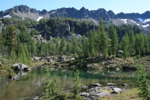
7.5 miles, 1290 gain/4558 loss. We hit the trail early, wanting to get over the pass before the heat of the day, and Dave has to go to work tonight, so it would be nice to get back home for a few hour nap before heading to work. As we pass the Leavenworthites, they call out as we go by, “Heidelburger!” to which we laugh, and reply, “Heidelburger!” It becomes our rallying cry all the way back to the car. The sun has not yet reached the valley floor, but as we look up to the ridge above, we can already see the sun’s rays moving down the rock towards the lakes basin. Up we go, picking our way up the ridge, then cutting off towards the middle of the cirque here above Cup Lake, onto snow fields then up a rocky outcropping in the midst of all the loose rock and ravines, allowing us foot holds on solid rock. It appears someone else thought this the best way as well, for we could see fresh boot prints in the dust and rock. Now, we’re above this rock ledge, onto another snow field, then up to the climber’s footpath that we followed down to this point. Coming over the day before, we lost this way down, and chose to go down steep ravines and gullies, washed out by the melting snow, that had little in the way of solid footing. Coming up, it was easier to see the way over this solid rock jutting out of the hillside. We left a cairn, so that anyone coming this way again, could see the best way.
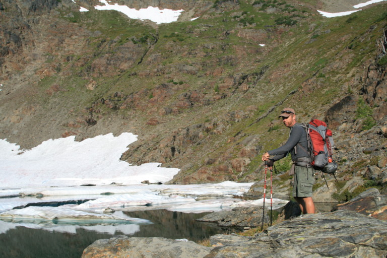
As soon as we reached the sunlight, you could feel that today was gonna be hot. By 10:00, we were standing at the pass. Now, it was all downhill! This time, we decided to follow the climber’s path down to the bench below, hoping to find a better route, and we were not disappointed. We followed the cairns and faint trail down to the bench in short order, deciding this was definitely a better way than the one we took. Once on the flat, we lost the foot prints, but followed the GPS to where I thought would be the best way down, and came to what looked as if it were nothing but an avalanche chute!


It looked as if someone had gone this way before us, but I was thinking, “No way would I want to come up this!” As we ventured into the chute, it was clear that this would not be a safe way to come up, for the loose rock, some of it large, immediately started sliding as soon as you took a step onto it. Then, as it started to slide, it started taking the rest of the hillside with it, and there you would be, in themiddle of a rubble slide, like having your feet in wet concrete being poured out the back of a cement mixer. Eventually, we picked our way down into the valley below, before facing our next hurdle.
“…The only time I was able to stop myself was if I grabbed a tree on the way by…”
Following the GPS track, we followed a stream downhill through a canyon filled with large boulders, trees, and slick heather and some kind of low growing juniper that once you stepped on it, on these slopes, you started heading downhill on your butt. My feet would literally fly right out from under me, and down you’d go. The only time I was able to stop myself was if I grabbed a tree on the way by. For about 200 feet or so, this is the way we picked ourselves down the hillside, fall, grab a tree, or aim at one as a stop block, then fall and slide into the tree to break your free fall. No good way to come back up this way, either. Sigh. I was so hoping to find at least one good way to get into the lakes via this route, but so far, nothing that I could recommend…Whatever happened to that beaten trail that we saw leave the trail? I was sure hoping we would run across it, but now we’re in the middle of a forest, sliding down boulders covered in greenery that would send you careening off a 15 foot embankment if you weren’t careful. Oh, well, we still needed to get down, so keeping the creek and ridgeline to our right we made our way down through trees and shrubbery, until it finally started to thin a bit, before reaching a small meadow.

Then, we found it. The trail! Here was a distinct trail with horse’s hooves and boot prints! This must be the path we saw on our first day, so we followed it all the way back to the main trail, another .5 miles away. We had found it, but just not where it ended. Had it found a better way onto the bench above us? And, if so, why had we not seen horse’s hooves up there? Questions that I had no answer for…Here where the trail meets the main, there is a small clearing, as if someone had camped here. “Heidelburger!” Seems appropriate as we’ve just cleared another hurdle on our quest for the car. We retrace our steps back towards the parking lot, and when we reach the brush, and hack our way through, there is another resounding chorus of “Heidelburger!” By 2:00, we are back at the car, and greatly relieved to shed our boots and packs, and climb into the car. “Heidelburger!”
“… I feel as if I could have eaten my way through 5lbs of the golden goodness set before me…”
The AC was another welcome relief, and by the time we got to Leavenworth, the truck thermometer registered a 100 degree mark outside. Whew. That was hot. We roll into the Heidelburger parking lot, and are astounded that we are the second people in line. So, within 5 minutes we have our anxiously awaited food, and we are not disappointed, I am sure that these tots are some of the best on the planet, and I feel as if I could have eaten my way through 5lbs of the golden goodness set before me. Hunger partially satiated, we make one more stop at the Starbucks, for some cool caffeine to keep us energized for the trip home.
“… But it can be downright stupefying to find out just how much can be crammed within the 20ft contour lines on a topo map…”
Remember earlier I said I would get to the bit about Topo Maps, and Google Earth? Sometimes they lie. Not intentionally of course, for without maps, where would we be? But it can be downright stupefying to find out just how much can be crammed within the 20ft contour lines on a topo map. Anyone that’s travelled enough in the backcountry knows to be careful about choosing new routes using a topo map, about how to tell what is steep and what’s not, (You know, the closer the lines, the steeper it gets, etc.), what a pass looks like and all that, but still…I like to take it one further and download the route onto Google Earth, that way I can look at it in 3D, to see if it’s doable. This has helped a lot in route preparation, but even with this new tech, there are still gotchas. Especially the way the software likes to “flatten” things out, in particular along a ridge line. I examined the Dead Horse Pass saddle from every angle, and thought that it was going to be fine.
Imagine my surprise on the first day, when we reached the ridgeline, and looked off of a 15ft sheer drop off, into utter madness. That, and Big Chiwaukum, (the highest of the mountains that we then straddled) looked as if it were made out of solid granite on Google Earth, with lots of snow around its top. Again, not so. It was loose, with huge talus and scree fields creating nothing but loose footing. That, and sharp jagged peaks and spires. I know better than to trust what I’m seeing from a satellite photo, but now…I really know better. It’s a tool to be sure, that should be used whenever possible, for it truly helps you shape in your mind how things are going to be when you get there, but still, there are caveats to consider when planning off course routes with GPS, topo maps, and Google Earth.
“…Immediately, the skeptic in me raced to the front, shoving aside the twinkle-eyed little boy, to say, “Naaaaaaahhh…”
And, one more thing. I know that when I was first planning this route over Dead Horse Pass, I noticed a peculiarity that grabbed my little boy’s fascination with buried treasure, of being the first to find something noteworthy. There, on the side of the mountain, was an airplane! No matter how I rotated the 3D map in Google Earth, there was a perfect airplane! Immediately, the skeptic in me raced to the front, shoving aside the twinkle eyed little boy, to say, “Naaaaaaahhh…Can’t be, look for the shadow, dimwit!” But there wasn’t one that I could find. Always hoping, but never completely rid of the grown up killjoy that follows me everywhere, I still made sure to mark on the map the hoped for plane, only to have the skeptic in me affirmed, for when we got to the pass, the only thing white in the rocks were the snowfields. The satellite camera must have snapped a picture at the precise moment a small airplane flew over the Chiwaukum Mts, and then the software flattened it against the mountainside, once again proving to the grown up cynic, the misanthrope in me that Santa Claus isn’t real, and that pots of gold and things undiscovered are for those more fortunate than I. Still, the boy with the twinkling eyes refuses to grow up, so there’s still hope for the dreamer in me yet.