Ranking: 4/5 One of the best day hikes I’ve ever been on. Huge views that let you forget that you are hiking steadily upwards, as you round this beautiful cirque in the North Cascades. During the fall, the Larch turn golden, and the huckleberry brush turns scarlet red, highlighting the rugged granite and steep slopes that dominate the area. As you get to each new saddle, pass, or ridgeline, there are new spectacular views of the surrounding peaks and mountains, complete with alpine lakes. You must see this North Cascades gem!
Difficulty: 5/10 It’s a relatively easy dayhike, only covering 6.5 miles and about 2100ft of elevation gain. Getting there, especially if you live south, is the most difficult, took me about 4 hours of driving to get there, although, the drive up the North Cascades highway offers its own unique views.
Getting there: Take I-5N towards Everett, and turn right onto exit 208, for highway 530 to Arlington/Darrington, then turn right at WA-530E, and continue to follow WA -530E for 50.3 miles. Take a slight right at N Cascades Highway, and follow WA-20E for about 60 miles, to Rainy Pass. Turn right into the parking lot, the trailhead for trail #740 is at the beginning of the parking lot to the left. This is the Maple Pass Loop Trail. Permits: Will require a Northwest Forest Pass, or equivalent, to park at the trailhead, and you must self register at the trailhead. Maps: I used the Trails Illustrated of the North Cascades, put out by National Geographic. Also available are the Green Trails Map #49 Mt. Logan, and #50 Washington Pass. Another source for more info, is the Okanogan/Wenatchee Natl. ForestWebsite, trail conditions, and Lake Ann/Maple Pass Loop Trail.
One more to go…This would make 10 hikes this year that I’ve submitted to Backpacker magazine and at the beginning of it all, it seemed like no big deal…A late season start, and midway through the 10, it seemed an insurmountable objective…But, here I am, the last one!
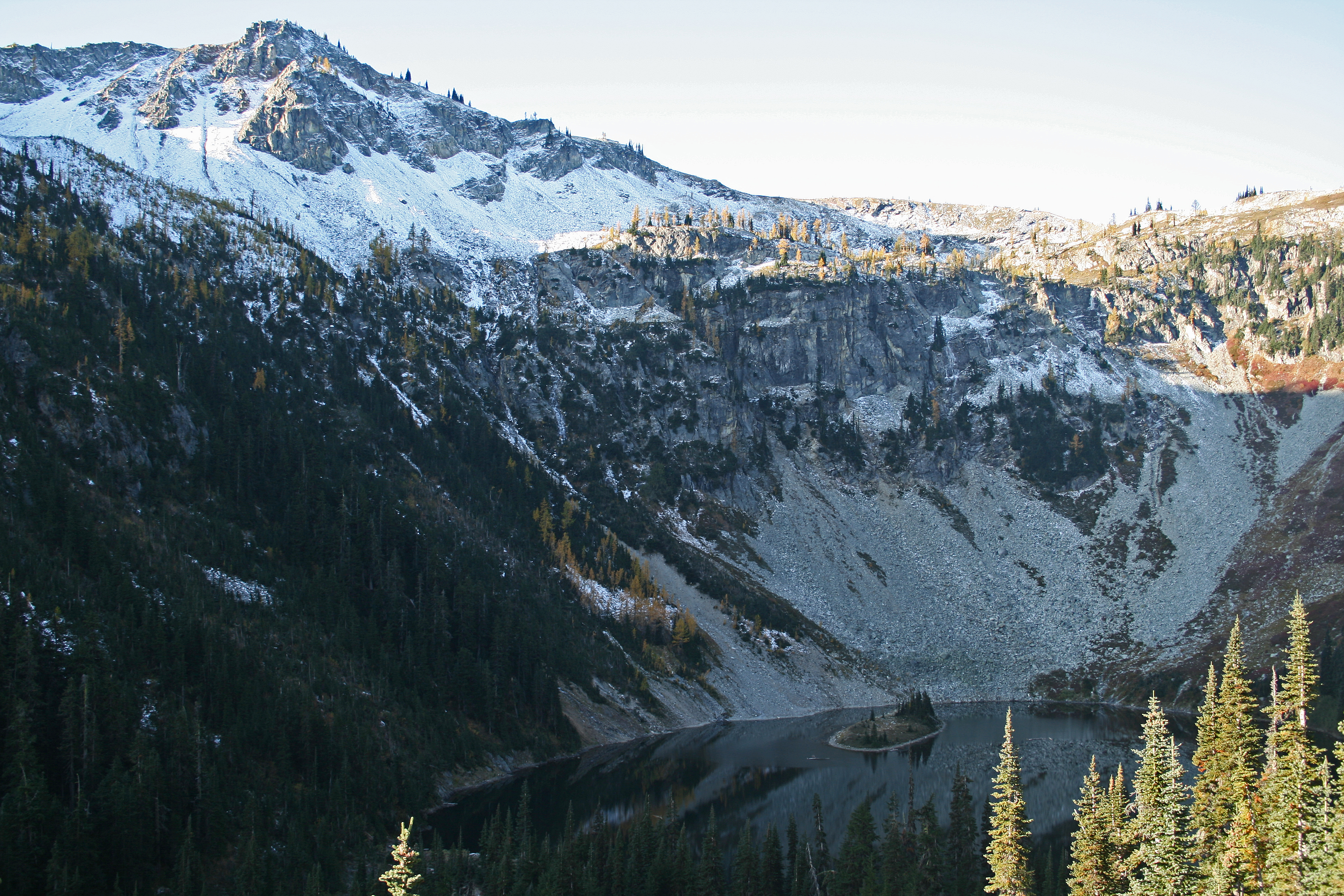
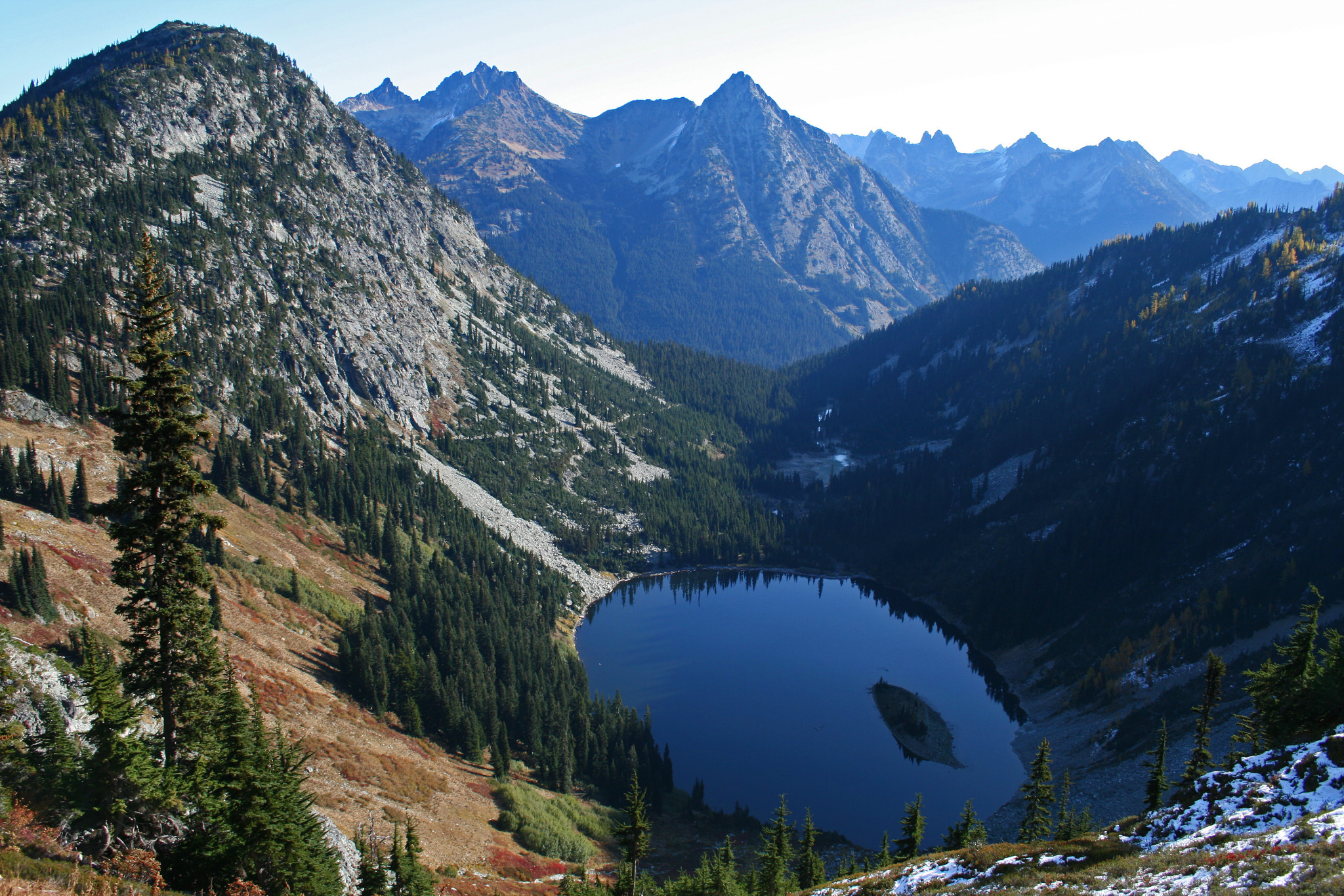
Lake Ann
…I know that I want to visit this area again, as the surrounding mountains are inspiring to be sure, very vertical and rugged…
Another day hike, but given its distance from the house, about 3.5 to 4 hours away, we decide to overnight close to the trailhead, and get an early start. I say we, because this time I don’t go alone, Sally will go with me, and we’ll spend the night at Buffalo Run Inn, at Marblemount. It’s still about an hour from the trailhead, but sure beats four!!! The room is very nice, and the food is great, I highly recommend the accommodations if you plan the same kind of trip. I know that I want to visit this area again, as the surrounding mountains are inspiring to be sure, very vertical and rugged, much different than the south Cascades closer to home.
…I note the temperature when I first get out of the car…19 degrees!
Huckleberry brush lines the bowl around Lake Ann, now scarlet red for fall.
I get an early start, wanting to be at the trailhead by 6:00am, so that I can hike the 6.5 miles, get back to the car, pick Sally up at Marblemount, and get home at a decent hour…First time I’ve ever gotten an “Alpine start” by car…I’m the first one at the parking lot at Rainy Pass, where the trailhead begins, and I note the temperature when I first get out of the car…19 degrees! Well, at least it’s not raining! The nice part about it being this cold is that instead of wringing sweat out of my shirts and hat, I’ll stay dry and let the hiking keep me warm, and motivate me to keep moving.
…I found the counterclockwise direction to be much more interesting for its constant visuals…
From all the data that I’ve been able to glean on this hike, it seems best to go counter-clockwise on this loop, up around the bowl surrounding Lake Ann, and then back down the other side, which seems steeper. You can go clockwise, of course, but that way, the beginning of the trail is constant switchbacks up to ridgeline, and not much to see to keep you entertained…I found the counterclockwise direction to be much more interesting for its constant visuals, as you escaped the tree line.
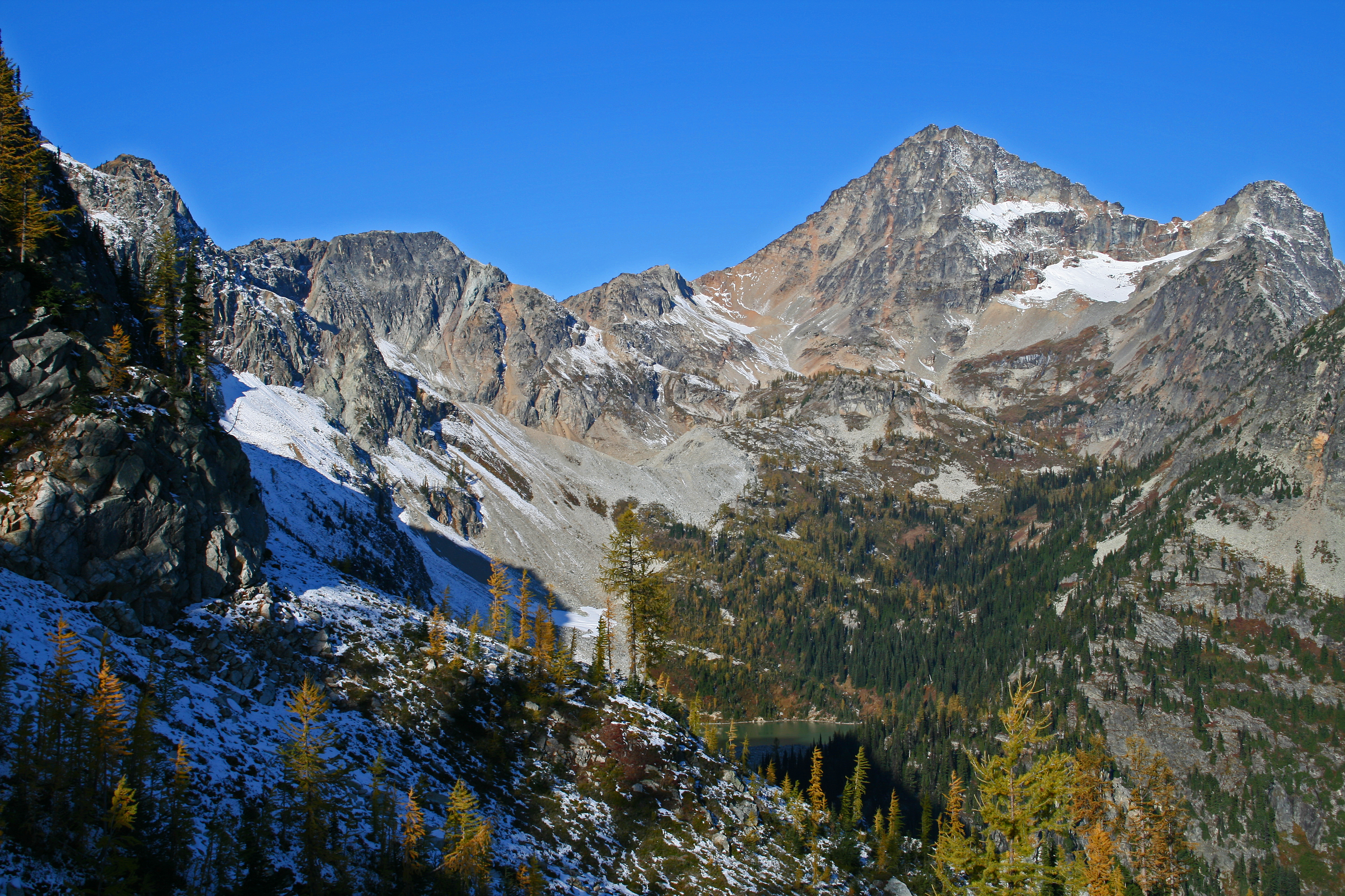
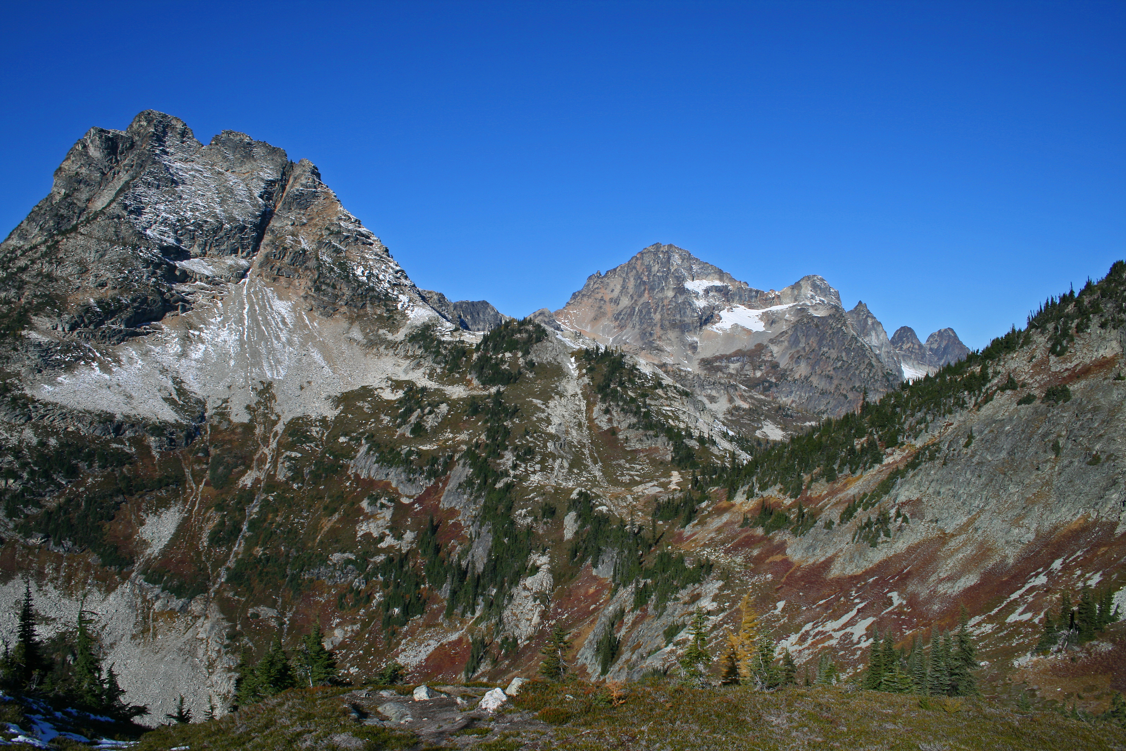
Black Peak
Heading up from the parking lot, it begins through thick forest, and does a good job of gaining elevation on gradual switchbacks and well maintained trails, making it easy on the feet. Just over a mile in, there is a trail junction that veers left towards Lake Ann, the alpine lake that you will be circumnavigating on this loop, around the cirque that surrounds it. Another half mile later, and you leave the tree line, and get your first glimpses of the area.
…The fall colors pop, as the red huckleberry brush at the distant edge of the bowl looks like a wildfire spreading up the slope…
You are now on large talus fields, interspersed with alpine firs, all above Lake Ann below. The fall colors pop, as the red huckleberry brush at the distant edge of the bowl looks like a wildfire spreading up the slope, the high point of the opposite rim across Lake Ann is edged in golden larch, just now starting to catch the first rays of sun, causing them to blaze brilliantly against the first dustings of snow for the year. Beautiful!
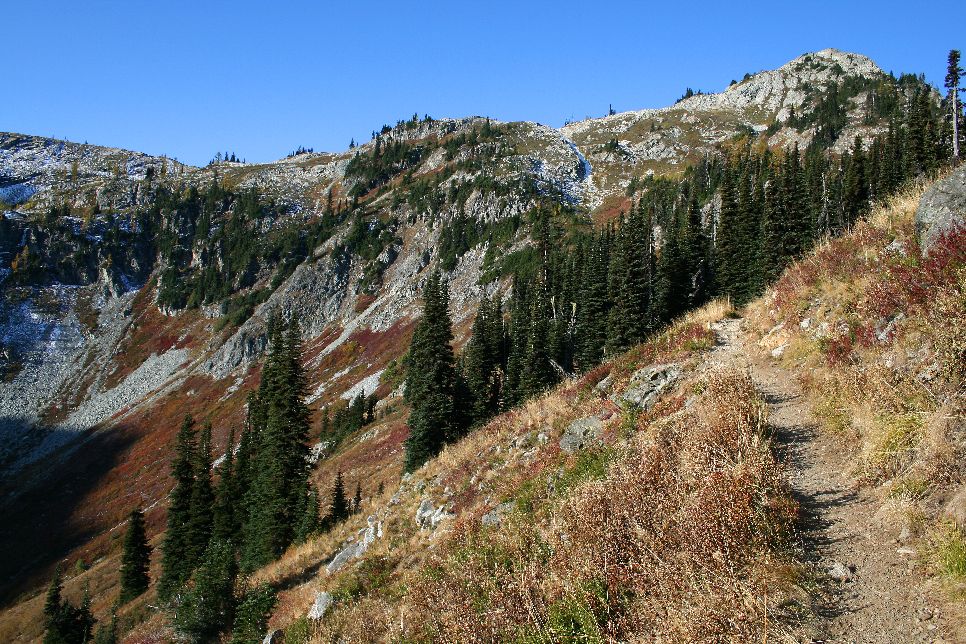
Heather Pass below the larch
It urges me onward, as I desire to get to the higher rim, for the first views of distant peaks poke above the bowls edge, filling me with the desire to see what’s over the next rise…The trail continues upward at a moderate pace, not steep at all, and the whole time, you have clear sight lines to the rim and the now slowly receding Lake Ann, a perfect tear drop lake, with a small island near its center.
…Wow, is all I can say…
At 2.2 miles, you come to a trail junction, near the top of the cirque, and this trail branches off across a small meadow in the gap, called Heather Pass. Stay straight past this junction, and a couple of short switchbacks bring you to an awesome viewpoint about 60 feet or so above the meadow here. Wow, is all I can say…The area is pretty worn down, from people stopping to admire the views, and who can blame them?From this vantage point, you now can see over the edge of the bowl, towards Black Peak, and the small lake that sits at its base, in another cirque, called Lewis Lake. Somewhere above it, lies another lake called Wing Lake.
Larch ring the lakes edge here as well, mingled in with the alpine firs, creating golden flecks of color against the green. Black Peak is dominant and steep, no trees grow on its granite crusted flanks, and large talus fields lay around it, from centuries of erosion and gravity.Looking back the direction you came, you can see another massive ridgeline, with Whistler Mountain and Cutthroat Peak beyond Rainy Pass, where you parked your car. Also visible, near the base, is a line cut through the trees, which is the North Cascades highway, running alongside Granite Creek.
…Highlighted by the suns’ rays, the needles glow as if they have an internal energy that is being radiated…
From the top ridge line of the bowl, looking down into Lake Ann.
It was difficult to tear my eyes away from the distant views here, but it was made easier by the fact that I knew there would be other enticing things to see once I reached the top, which now was close. The small pockets of meadows here are filled with huckleberries and speckled with Larch, which has now put on its fall show, the needles having all turned to gold. Highlighted by the suns’ rays, the needles glow as if they have an internal energy that is being radiated. I snap away with my camera, hoping desperately to be able to capture the light they seem to emit.
Finally, I’m on the far edge of the bowl above Lake Ann, which looks tiny from the heights…From the top of the ridgeline here, there is another trail that leads down the other side into the Maple Creek drainage from this unnamed saddle. Again, the views are incredible! Across the valley floor below your vision is guided up, up, the steep face of Corteo Peak, looking every bit as if you were transported to the Alps, the striations in its rock face filled with snow, accentuating the lines that run horizontally across its face, like a furrowed brow. All the lines here are stark and fractured, leaving lines and edges that appeared like broken glass.
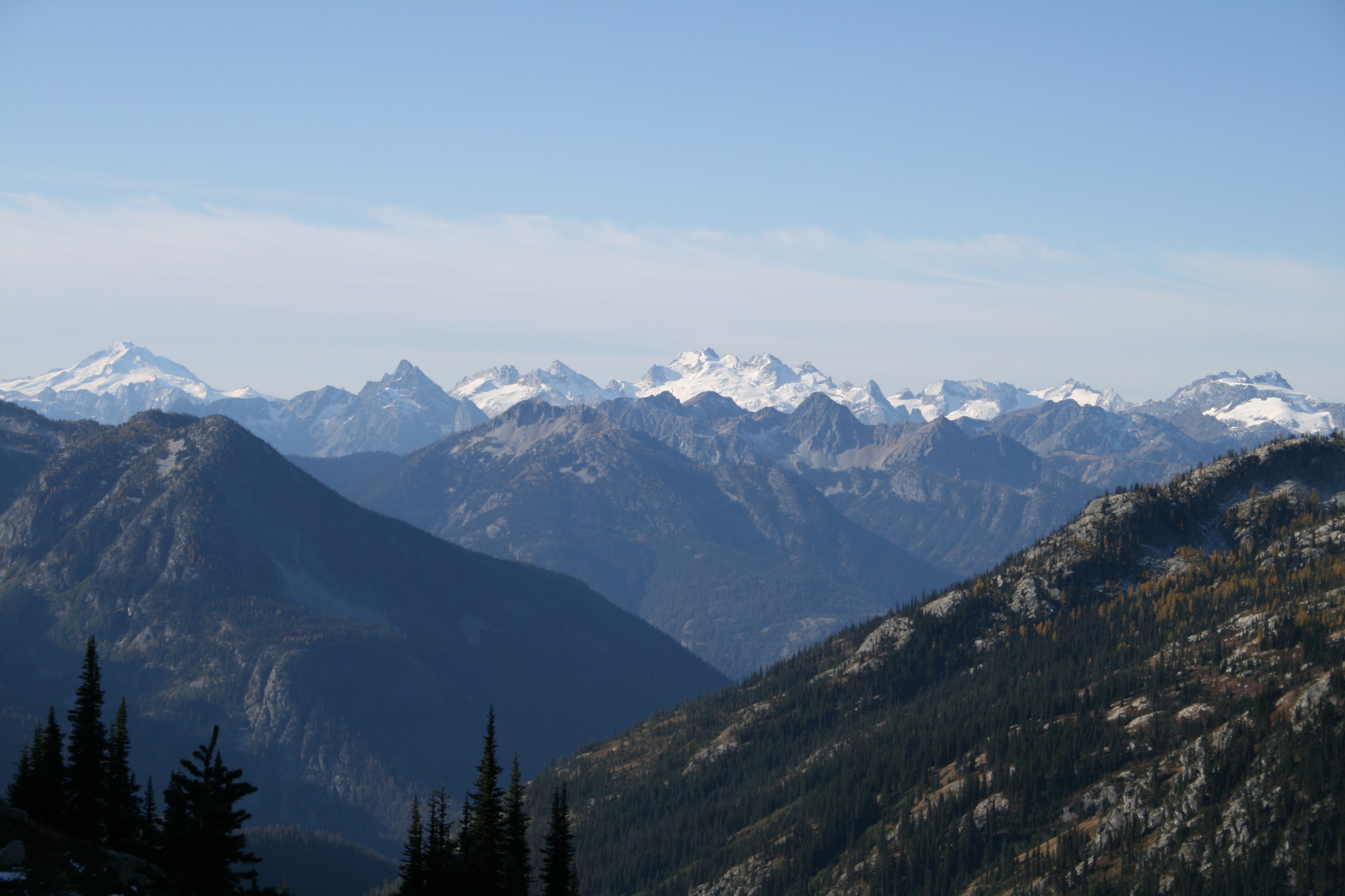
In the distance to the right of Corteo Peak, you can still see the top half of Black Peak rising above the ridge that runs from this saddle to the right flank of Corteo Peak. Looking west/southwest from Corteo Peak, across the far distance, you can see several glaciated peaks all in row, part of the Glacier Peak Wilderness. I can only assume from the maps, that I’m now looking at Gunsight, Sinister, Dome, and Spire peaks. Totally amazing!Again, I find it hard to move, as I’m transfixed by what my eyes can hardly believe they’re seeing. With reluctance, I continue on.
Of course, the sheer number of little trails running everywhere leads one to the conclusion that there is no one best place…
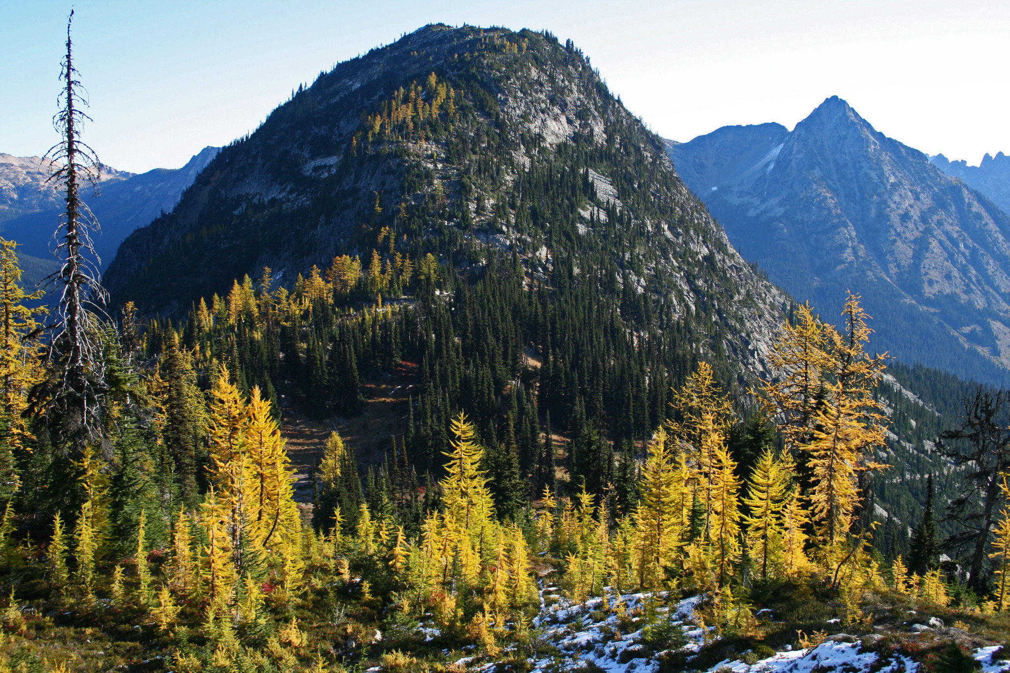
Another view of Corteo Peak, rising above Maple Creek drainage
The trail wanders everywhere here on top, as countless people have roamed about, trying to take it all in. A trail wandering here, to see over the edge down into Lake Ann, another here in an attempt to get a better view of the distant glaciated peaks, and still others that run to and fro, looking for the best place to see it all. Of course, the sheer number of little trails running everywhere leads one to the conclusion that there is no one best place. It is unfortunate, though, for the foot paths that lead everywhere/nowhere have beaten down a fair amount of the alpine tundra here, small meadows that have taken eons to grow atop the stark granite.
Distant glaciated peaks in the Glacier Peaks Wilderness
The trail that runs the down the middle is the most heavily used, and is the main trail here. Up and over a few small rises, then climbing slightly once more to your last saddle at 6967ft, another high point at the edge of a ridgeline that leads to Frisco Mountain, to your right. Now, you can see all the way down towards Rainy Pass, and steep meadows filled with browning grass, the trail zigzagging back and forth across the slope.There is another small tarn below you, at the base of a snow field, also unnamed on the maps.
…would you believe it? I’ve given my camera such a workout that the battery has died…
Another step below that is Rainy Lake, and the waterfall that leaps off the ledge below to feed it. There is also more larch growing here, and would you believe it? I’ve given my camera such a workout that the battery has died. At least, I tell myself that, but in actuality, I’m sure it’s because it did not start with a full charge.
Corteo Peak, with Black Peak in the background.
As I head down slope towards the car, I begin to pass people, the first I’ve seen today. Usually in groups of 3 to 5, with dogs. We stop to chat every once in awhile, remarking on our good fortune to be able to see this on such a beautiful day. It’s sunny, of course, but still cold. The temperature never rises above 30 degrees the whole time, but hey, you know what? It was a dry cold, so it’s not so bad… At one point the ridgeline trail here becomes narrow, like walking on a knife’s edge, and from this place on the trail, you can see straight down into Rainy Lake below, and the waterfall above it. Although, today, because of the recent temperatures, it is now a giant icicle, frozen solid, hanging from the precipice that it runs off of.
…This part of the North Cascades is truly epic in spectacle…
Won’t be long now, and the region will be covered in its winter blanket of snow. Back to the car, I load up, and I’m amazed that I have not ventured into this part of the state before. I’ve been missing so much! This hike has it all. 6.5 miles and only 2100ft of elevation gain. It’s a moderately easy day hike, with huge rewards.This part of the North Cascades is truly epic in spectacle, with impossibly steep granite peaks jutting into the sky at every angle. And, as you continue your upward trek, reaching ridgelines with incredible vistas, you think you’ve seen it all, until you reach the next ridge, or saddle.
…I vow to come back, to wander again along trails that cut through the heart of such rugged beauty…
Trail along ridgeline, Corteo Peak and Black Peak still visible.
It’s hard to imagine that there can be so much to see, each view as spectacular as the last, all highlighted by fall foliage, sun lighting up the golden larch trees that are everywhere, surrounded by the deep purples and reds of huckleberry brush amidst white and dark granite, creating a landscape of otherworldly proportions. Then, in the midst of it all, plop a small scenic alpine lake complete with its own small island, and it makes it hard to take your eyes off of the visual feast of colors, shapes and vivid landscapes that seem to run on forever. I vow to come back, to wander again along trails that cut through the heart of such rugged beauty.