Day 2

(or is it day 4?) 6676ft elevation gain/loss, 12.76 miles. By 4:00am, I’m up, dressed and having a cup of joe. By 5:00am, I’m on the trail, with headlamp blazing. A group of 3 kids had started out before me, having arrived by car at around 4:30 this morning.
I was the only one that had camped here last night, and most of the cars were now gone from the day before. I passed them about 30 minutes later, and did not see them again except for their headlamps through the darkness once I started climbing the ridgeline above Morrison Creek. The creek this time had no water, as the night temperatures had no doubt frozen the glacier once more.
Up, and up I went, this time with a much lighter load. It was still dark when I reached the 8000ft mark, and was able to see where I had spent the night a few weeks previously. That seemed like such a long time ago…Finally, just as the day approached, bringing with it more brilliant crimsons to paint the sky with, I reached the flat area at 9000ft, where I had turned around before.
…and I could feel my stomach rolling, with twinges of apprehension, and nerves I suppose…

From here on, everything would be different now, and I could feel my stomach rolling, with twinges of apprehension, and nerves I suppose…Is it possible I’m also feeling the slight symptoms of altitude? It’s possible, but I try to ignore all of this, and instead concentrate on the task at hand, namely, making sure I pick the right line up the mountain. I don’t want to have to backtrack.
The map I was using was a route that I had found on SummitPost.org, and then traced it as best I could into a track file for my GPS unit, and it showed a route that basically just went straight up, staying far left of Suksdorf ridge, and the glaciers on its western side. Since I don’t have crampons, I stay off of the snow/ice fields, and stay in the boulders to the left. Within an hour, as I’m struggling over the volcanic boulder fields, I begin to doubt my choice of direction.
…am dismayed to see a whole field of boulders perched one atop another like some jumbled orange display at the local market…
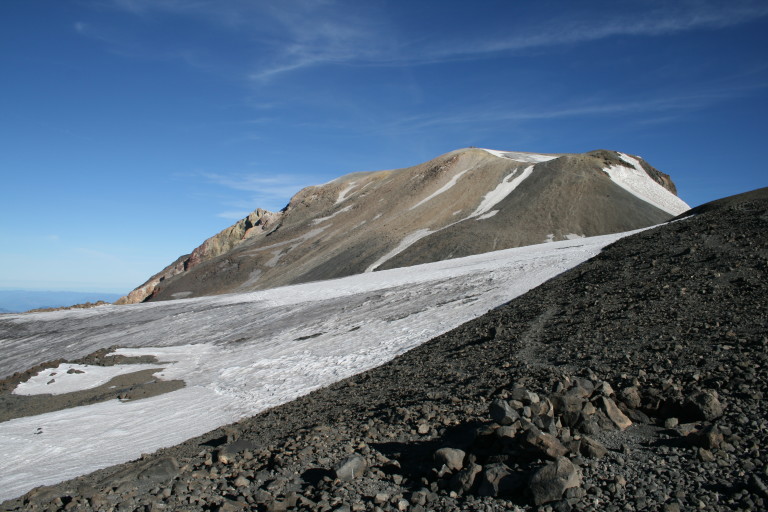
I can look up, and see the ridge line above me, and it’s obvious that I’m heading in the right direction, but this no longer seems safe. The angle has now grown steeper, it has to be around 30 degrees or more, and some of the footstool sized boulders are beginning to shift under my feet, causing me to come to a dead stop. I look up slope, and am dismayed to see a whole field of boulders perched one atop another like some jumbled orange display at the local market. Pull the wrong one out, and you’ll be pickin’ them all up off the floor, while the disgruntled shop keep calls for cleanup on isle catastrophe…Not good.
My hands immediately begin to sweat, and I start looking around for a safe way to get off of this possible nightmare. I have to do some backtracking, but find a better route, and a safe way around this treacherous boulder field, and avert a cleanup crew being called out…Once on the ridge, I can see several other climbers ahead of me, they must have spent the night somewhere on the mountain, but I don’t remember seeing a campsite. Perhaps they were at Lunch counter?
…Above me the other group had ventured out onto the glacier on Suksdorf ridge, and it appeared they were moving very slowly…
I can now see far below me, and no longer am able to discern the 3 that I had passed earlier in the dark. Had they given up, and turned around? Perhaps they needed to wait for daylight, to see the trail better. I know that might have entered my way of thinking, if I had not already been here once before, and knew what to expect…Above me the other group had ventured out onto the glacier on Suksdorf ridge, and it appeared they were moving very slowly.
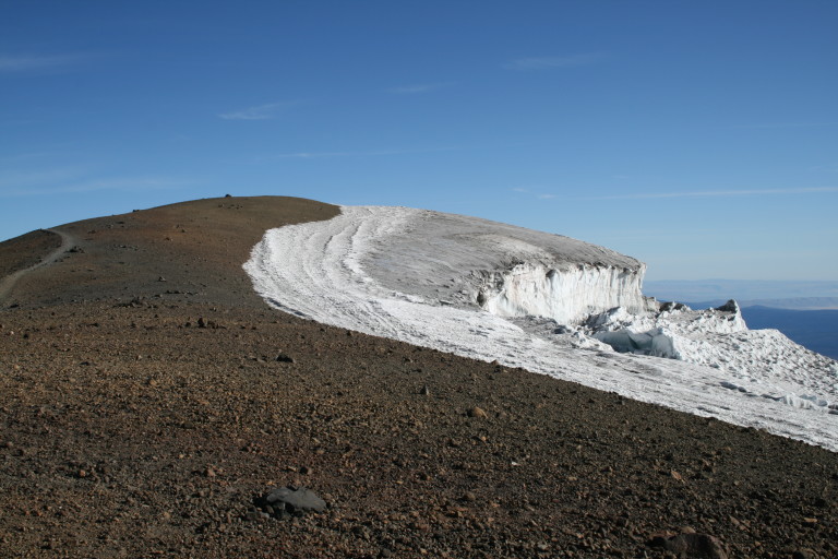
In places, the glacier undulates, creating a steep bank, like a frozen wave just looking to punish you, if you weren’t paying attention. I decide to stay off of the ice, and only cross it in places where I can cut across at a less severe angle. Still being cold, the surface is frozen, and the sun has not melted it yet, so it provides some “stiction”…Back and forth, you can see a weaving uphill trail worn into the much smaller sized volcanic rock, and sand. Your foot sinks in here, and its take two steps forward, and one back most of the way now to the false summit, an outcropping that by now is blocking the top of the mountain. It sits at the western edge of Piker’s Peak, a true false summit at 11,667ft.
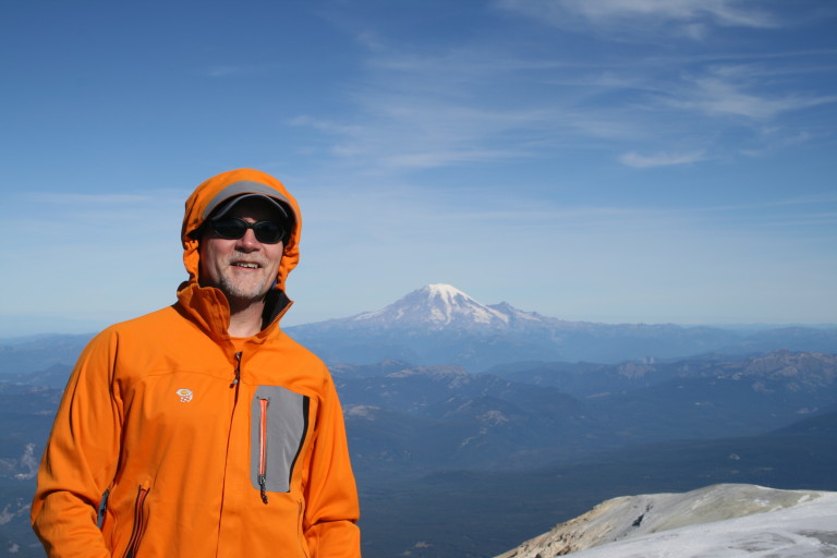
The last 30 or 40 feet to the outcropping is steep, and the ground shifts around your feet, but it is worth stopping here for a few minutes to admire the view. At this point, you are now at 11, 520ft, within striking distance from the top! You can see all the way south to Mt. Hood, and it was clear enough today to see Mt. Jefferson, peeking out from behind Mt. Hood. Mt. St. Helens is also visible here, as well as the top of Mt. Adams. By now, it’s just a little after 9:00am, and I feel that I’m making good time. Up and over Piker’s Peak, and across the frozen snowfield here in the saddle.
…My voice is almost completely gone, and sounds instead like that of a toad…

As I approach the final ascent, I begin to smell sulfur, and it’s strong. I look around to see if there are any vents here, but I don’t see any. Above me, I still see the other group, making their way to the top. Right at 11:00am, I reach the cabin perched on the top, and see the other group there, taking their hero shots. We are the only ones here, and as I approach them, they shout hello, for it is windy and cold here, and I’m surprised that as I respond, I’m only able to croak out a few syllables that sound like hello, in return. My voice is almost completely gone, and sounds instead like that of a toad…
…but I decide to stay for a bit, exploring the top here, and making sure that I walk over to the USGS elevation marker, the true summit…

I offer to take their pictures, and learn that they had camped near Lunch counter last night. They seemed somewhat surprised to learn that I had left from the parking lot this morning. Thankfully, they also took my picture at the top, not sure if the wind would allow me to set up my tripod without tipping the camera over. It’s only about 38 degrees up here, and with the wind whipping, it feels much colder. They say their goodbyes and head down, but I decide to stay for a bit, exploring the top here, and making sure that I walk over to the USGS elevation marker, the true summit. There is a memorial here at the cabin , a young man from Wilsonville, Oregon.
…I decide to follow this new path way down, it looks eminently safer than the route I took up…
Now, I can also see Mt. Rainier from here, and am overjoyed that the weather is clear, so I take pictures till my heart’s content. A little lunch, and I leave the highpoint, and follow the other group down slope. Once I approach the first little false summit, I am able to see a different route down, a zigzag climbers trail etched into the ridgeline below me. Funny how a different perspective allows you to see something different…I decide to follow this new path way down, it looks eminently safer than the route I took up, and its here that I run into the 3 people that I first saw at camp.
…when I pass him, I hear him mumble under his breath how he doesn’t think anything about this has been a cake walk…
One of them is wearing hard plastic boots, like ski boots! I try and encourage them by pointing to the rock outcropping, and telling them that once you reach that, it’s a piece of cake! I get a frustrated look from the guy wearing the plastic boots, and when I pass him, I hear him mumble under his breath how he doesn’t think anything about this has been a cake walk…It’s at that point, that I realize I might indeed be enjoying some of the lightheartedness I noticed from the other climbers yesterday at camp. My mood does not seem nearly as dark as plastic bootie man….I am glad that I chose to come down this way, for not only is the climb less severe, (easy for me to say as I’m going down), but the views here are awesome!
…My mood does not seem nearly as dark as plastic bootie man….
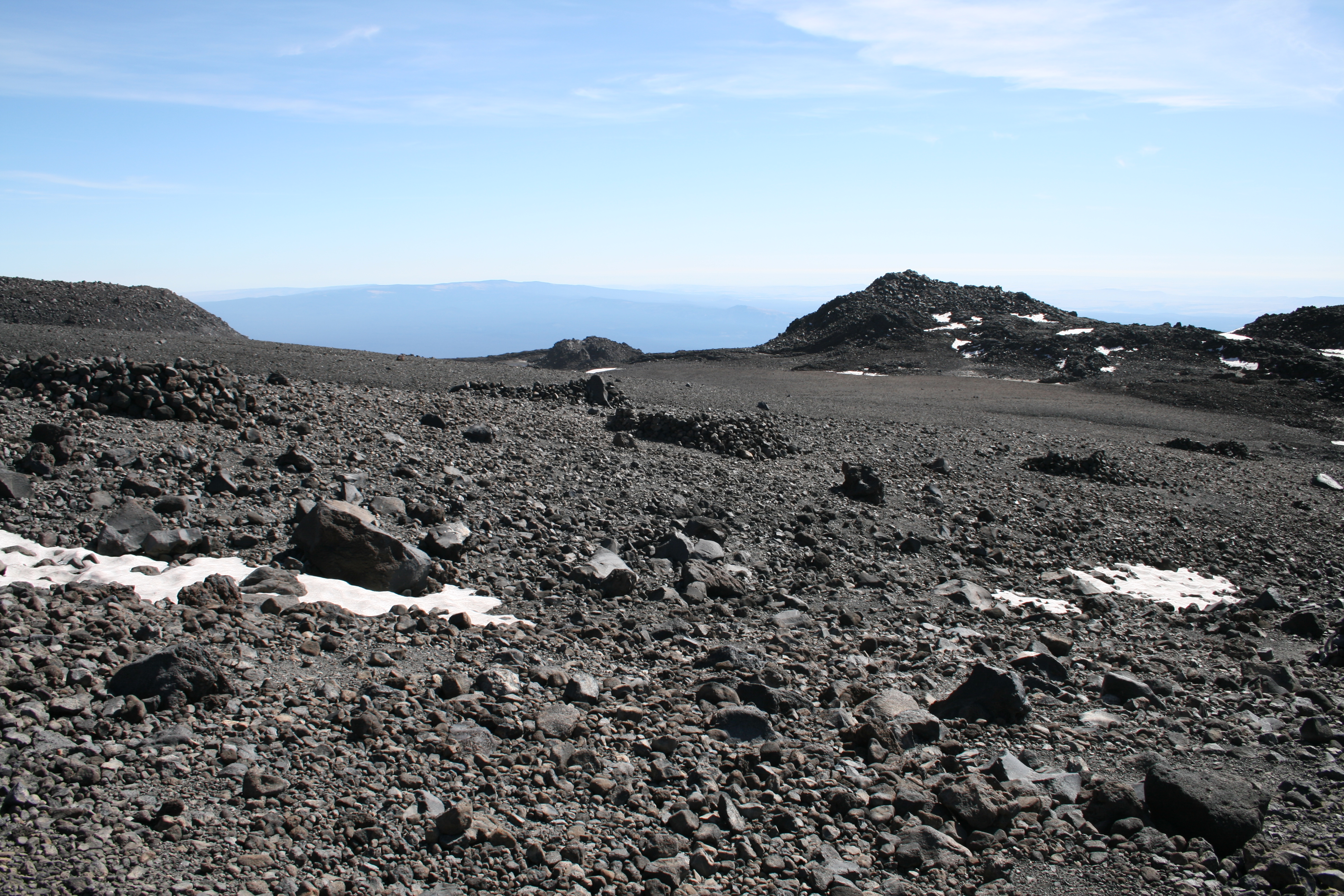
I am looking at the Klickitat Glacier now, and its huge, monolithic blocks of ice hanging haphazardly from the face of the glacier, as it continues its slow motion cascade down the slopes. The frozen blue water from deep ice is visible in the cracks and a stark contrast to the blacks and reds of volcanic rock. From here, I’m able to look East, down into the valley that the glacier has carved between two ridgelines, the Battlement Ridge north, and the Ridge of Wonders to the south.

The trail here finally ends at the flat area known as Lunch counter, and there are several of the wind breaks made of stone here, that will shelter many tents. The heat of the day is now beginning to melt the glacier, and several rivulets of water are now cascading off of the Suksdorf ridge snow field, that must be crossed to getback to the other side, the flat where I was first stopped last time I made an attempt. Here I pass a few of the guys that were with me on top, and now that I’m on familiar ground once again, I continue my headlong plunge down the mountain to base camp.
…I spy a snowboard that someone has jettisoned. Guess they decide that boarding over a volcanic flow doesn’t seem to be what they had in mind…
Near the 8000ft mark, near a cluster of rock windbreaks, I spy a snowboard that someone has jettisoned. Guess they decide that boarding over a volcanic flow doesn’t seem to be what they had in mind… By 3:00pm, I’m back to Cold Springs camp, overjoyed that I have made it to the top! I hurriedly pack, for now it’s Monday, and I must go to work tonight…No matter, I’m sure the euphoria of having bagged another mountain, will go a long ways towards giving me the energy necessary to get through the night.