Day 3
12.2 miles, 3457ft gain/4266ft loss. Fitbit Steps: 41,593 Yeah, on a big elevation gain day, (most of it in one section), it’s amazing to get home and see that there was actually more downhill than up on this leg…
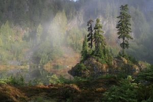
About the time for us to get up, the rain stops. I listen for about 10 minutes to see if it’s really given up, then quickly dress and crawl outside. To heavy fog. At least at the ground level, looking up, I can see blue sky trying to melt off the higher clouds, sot that is a welcome sight. Still, not wanting to push our luck we hurriedly loaded wet gear and headed out, skipping breakfast, the most important meal of the day…But, by the time we reach the lake, sunlight was now filtering through the mist. We decide not to skip breakfast, and sit by the lake and sup…

In an effort to pack light, we both had decided to leave rain pants at home after seeing the forecast. Again, don’t trust forecasters. They either tend to exaggerate, be clueless, or downright lie…They lied to us on this one. In retrospect, another lesson learned over again. Within minutes of hiking down the brush lined trail, we get soaked as the water gets shaken off onto my boots, which might take a quick dunking before getting wet through, are no match for constant watering down from the wet brush, and the tops of my feet are wet. 20 minutes later, we’re at the bottom of a series of switchbacks to our first crossing of the Duckabush River, at 1.8 miles. The couple that we saw yesterday has beaten us to the river crossing, and has already donned their river shoes for crossing. We spend some time looking for a dry way over the rushing water, and by heading right upstream, we find a place to boulder hop, and cross a narrow rapid. We also find another set of sunglasses, our second set, but leave them behind. Perhaps the owner is doing a loop like we are, and will find them on the return trip. Perhaps they’ll be just more flotsam that will get carried away with the river as it melts out next spring, too…
More downhill through rainforest to the trail junction for Home Sweet Home. “Hey, Greg, can we take this route? It sounds pretty good right now…” Sighing, and checking the map, we’re not headed that way. This junction is at 4.4 miles. The map says there’s supposed to be a shelter, called of all things, the Duckabush Shelter…But, we don’t see it here at this small CG. The bear wire is strung up, though…At 4.7 miles, you come to the second crossing of the Duckabush River, and this time, there is no avoiding taking the boots off…It’s braided here, so once you cross one section, just keep walking across the small island to the other braid and cross. It’s not deep, so no big deal, other than for lazy hikers like us that just don’t want to take off boots. Well, that, and I spend some prep time in camp putting Body Glide on the ol’ dogs to help fight off blisters, which I must say, has worked well. What doesn’t work so well, is peeling the socks off, crossing a river, and then capturing some of the sand and grit in the Body Glide….So, you end up wiping a lot of it off on the opposite bank, and again, this lazy hiker ain’t putting more back on, because, well, I might actually have to dig into my pack and look for it buried somewhere…
Finally re-booted, (you like what I did there? Re-booted?? Never mind…) we continue our trek/slog along the might Duckabush knowing that at some time, we must make a big uphill push to get up and over LaCrosse Pass. Hey, no worries, right? Just put the head down and forge ahead. Like everything else here, we’ll see the sign as we come to the junction, so with heads down, we just concentrate on making up as much time as possible by marching along, trying to at least put the couple that’s ahead of us in our sights. I think they too, were heading for Honeymoon meadows, so we already know what kind of slim pickings for sites are ahead of us, sooo…We try to catch up…
“…Instead of seeing the reassuring ribbon that I’ve pre-loaded onto the Garmin, it looks as if we’re blazing a new path…”
Along about 7 or so miles up the trail, I decide to look at my GPS again, little warning bells are going off in my head, knowing we’ve made some good time, and I’m beginning to wonder, where the trail junction is? I’m instantly dismayed as soon as I look at the screen. Instead of seeing the reassuring ribbon that I’ve pre-loaded onto the Garmin, it looks as if we’re blazing a new path. “Dang it, Greg!! (ok, the language may have been a bit more colorful, I admit), I don’t see our trail, what the heck!” It takes me a few minutes of zooming back out to see that we have passed out trail junction some distance back…
“…That’s what happens when you just put your head down, turn the brain off, and beat feet down the trail…”
We backtrack, this time keeping a close eye on the unit. How in the WORLD could we have passed what should be an obvious junction??? I can’t believe it…This would not be the first time, though, that after having traced a route using TOPO maps at home to get out in the field and find that the trail no longer exists or has been moved a considerable distance, so at once, I’m not trusting…I’m also, from past experience, more inclined to believe the GPS unit and what it’s trying to tell us, than to keep going, hoping we’ll find the trail head moved. So far, these 3 days, the trails have been pretty spot on as to location, so we decide to backtrack. Right at the spot, at 6.31 miles, we see the junction now. It’s at a perfect right angle with the trail, and NOW we see the signpost. Just the post. And, the trail sign is lying on the ground, face up, a little back of the trail, just like the one at Anderson pass was on our second day….DOH! We must have been so focused on just getting down the frickin’ trail that we blew right by it!!! I stand there in absolute disbelief…That’s what happens when you just put your head down, turn the brain off, and beat feet down the trail, you might miss something, like a trail junction…
“…I feel fortunate that Greg is not looking for the nearest tree to throw a noose over…”
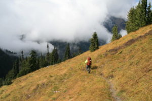
Back on track, its now a constant uphill switchback fest. For the next 3.1 miles, we do nothing but head endlessly up into continuing forest. Back and forth, back and forth, relentlessly gaining the required 2840ft of elevation in the process. About halfway up, we run into the older couple, and they say, “Hey, we remember you!” It’s an opportunity to rest, and chat for a second…”It was sunny on top when we headed down!” Good to hear. I ask them if they had seen anyone else in front of us. “Yes, a couple and another guy by himself”. I think we know those people. This trail only leads one place, so it appears that we might have some company when we get to Honeymoon Meadows…Thanking them for the info, we continue our slog upwards. Towards the top, the trees thin, and the golden grasses are back. As is the fog. Just below La Crosse Pass, the grass disappears and the fog lifts somewhat. We stop for bit at the pass, at mile 9.39, and 5546ft elevation, to rest. To take a load off. To catch our breath. To enjoy the fact that we’re not struggling up a never ending hill…I feel fortunate that Greg is not looking for the nearest tree to throw a noose over…
The pass has lots of shattered boulders built up in a small bowl to the east of us, and looking due west along the ridge we just crossed we can see the peak of Mt. La Crosse hiding shyly behind the swirling fog. At least now we’re above the tree line and can see for distance. From here, the trail is a constant downhill now across golden grass meadows and we can see across a tree lined valley that will eventually lead us to the base of Mt. Anderson once again and camp for the night. Mt. La Crosse too, has some personality to it, it has a pretty steepled top to it, which is devoid of trees, but there are ridges between gray scree fields that allow the trees to grow most of the way to the top, like greenbelts. It’s hard to get pictures, as the fog refuses to leave the highest reaches of the peaks, leaving the rest to our imagination…
We finally re-enter the tree line around 10.5 miles in, and then hit a long series of switchbacks that drop us back to the trail junction we passed on our second day, the signage here telling us that back behind us is the way to La Crosse Pass. What we didn’t see on the second day, though, was only about 30 yards or so from the trail junction, there is a nice campsite here next to the stream that comes down from La Crosse Pass. We never catch the couple, (our little 1.5 mile detour didn’t help much), so we decide that this is close, and actually a better campsite. Lots of room here next to the trail, it’s by a large flat topped boulder that makes a great bench and place to cook and there are trees to stretch our bear bag cord between to hang up soggy tents to dry. Yep, the sun that was giving us some sense of hope on the way up decided to go into hiding once again, as the bully black clouds pushed their way to the front. That, and the fog. For the moment, it stayed at peak level, but every once in a while it would make an incursion down to the surface, like a camp robber swooping in to see if there were any goodies to swipe, then quickly flitting away. As long as the breeze was blowing, though, we thought we could still get our gear somewhat dry before setting up. The trail ends for us here today at 12.27 miles. Our shortest day for mileage, but definitely our best butt kicking too, as that long uphill really took it out of us…Assessing the damage, though, it’s not bad. We’re both worn out, but even with wet feet and boots, there are no blisters, and no real injuries other than to pride after having missed a trail junction…I’m still incredulous, cannot believe it. Even with the sign missing, well, lying on the ground, we’ve found other scarcely used trails that were not nearly as obvious as this one was…
We gather water, and then set up mostly dry gear, thankful for the opportunity to get things this dry. Then, after dinner we sit around and watch the gathering gloom sit in. It hasn’t really rained, just a few sprinkles, but the fog is no longer lingering, it’s come in full force. By 9, its pitch black out. There will be no star gazing tonight. Into bed we go…
Thank you! And, I suppose a thank you to borvest inkral is in order, too? Is this a community forum as well? I notice there are different e-mails attached to it…Anyway, as far as community forums, no, i’m not aware of any, I know that I had some difficulty sometimes getting information on different hikes that I was interested in, so I decided to create a site that listed the places that I had been to, and what I thought about the conditions, views, etc…Again, thanks so much for the nice reply!!