Ranking: 3/5 This trail would have ranked higher if so much of the time wasn’t spent in the trees, slogging long miles to get to the tops of ridges so that you could see. When you do reach the tops of ridges, there is lots of country to see. We side tripped to see what was left of the Anderson Glacier, also kind of a disappointment as it was more lake than glacier One thing this trip does have is an abundance of shelters, and campsites with bear wires, seemed most places we stayed at or passed by had one.
Difficulty: 9/10 There is simply no avoiding the fact that this is a long hike, lots of miles to get to a few vantage points where you could see. A majority of day 2 was spent on ridgeline high above the Enchanted Valley, but the views, although good, were far from inspiring. Signage, in many places was blown down, and now simply propped up, so you will have to pay close attention to mileage to make sure you don’t pass a trail junction. There will also, in addition to the long miles, be stretches of constant up over trails that are in dire need of maintenance, so this hike is only recommended for hikers that are experienced. Not a trail to take if you’re just getting into the back country!
Getting there: From I-5 in Olympia, take exit #104 for US 101N, and follow 101N for 5.5 miles, where you will have to take a slight right to continue onto 101N, the signs will say to Shelton/Port Angeles. Stay on 101N for another 54.6 miles. Once you reach Brinnon, turn left onto Dosewallips Road, and follow it 9.8 miles to the end. The road is washed out here, and you will park on either side of the road.
Maps: We printed our own using My TOPO maps, as this is a large area to cover for a single map.
Permits: To camp in the Olympic National Park, the fee as of June 2015, is $5 per person per day, and you must register at the closest WIC, which is the Staircase Ranger station. Also, to park at the trailhead, you will need a Northwest Forest Pass, or equivalent. Here is the website for fees, reservations are not required on this hike. http://www.nps.gov/olym/planyourvisit/feesandreservations.htm
Mt. Lacrosse Loop Added 10-2-17
The weather report looked good enough…Friday 20% chance of showers, Saturday and Sunday, mostly sunny with temps hovering around the lower 70’s. Perfect, we thought, for a trip into the Olympic Rain Forest! So, packing as light as possible, we outfitted ourselves for a 4 day trip around Mt. Lacrosse and White Mountain, into what looked to be a rugged hike, with lots of mileage into a section of the Olympics that looked to me to be an area not often visited.
I based this on the fact that I had seen little as far as pictures of the area, or trail beta. More on this later…
Day 1
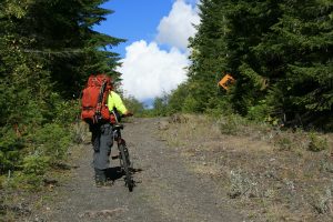
15 miles, 4073ft gain/1140ft loss. Fitbit Steps: 37,213 Greg and I leave my house at 6 in the morning, and are at the Dosewallips River trailhead by 10:30, and unload the mountain bikes that we planned on riding up the road to the Dosewallips Campground, now a walk-in as the road was washed out here by a storm in 2002, where we had to park, about 6 miles short of reaching the campground…
On the map, it looked pretty straight forward, the road follows the river up, so how hard could it be to ride all the way to the campground with a 45lb pack strapped on…Right? Wrong…After portaging the bikes over the wash-out (we went along the river bank, following the hordes that had gone before), and once on the opposite side, we jumped on the bikes, and started pedaling…And pedaling, until we decided, “Uh, no…Not gonna waste all our energy grinding away uphill” even though it seemed like such a gradual grade. It was disappointing, as we both feel we’re pretty fit, trying to ride uphill with the packs on was no match for our legs, as they started burning and cursing us straight away…
So, we ended up pushing the bikes most of the way, conserving our energy for the 9 or so miles after we got to the campground…The old road is now a super-wide trail, already the forest is quickly creeping in on both sides, with trees falling here and there across the way. Some have been cut out, but many remain, creating nuisance road blocks.
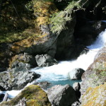
“The thunderous roar of tons of water pouring over a large, boulder strewn bed is quite impressive…”
At 1.45 miles in, you come to the first (now walk-in) CG called Elkhorn, and the road continues its slight upward grade across a couple nice wood bridges until you reach a huge rock cliff face which crowds the remains of the road between it and the river, creating a cool, stair stepped waterfall, called the Dosewallips waterfall, at 5.42 miles. The thunderous roar of tons of water pouring over a large, boulder strewn bed is quite impressive, the blue waters churn amidst white froth, making it too tempting to pass up, so we get a respite from pushing the bikes up this steep section of road to take pictures.
Near the top, you can still see the old road signs when vehicles used to ply this road. A sign, I thought particularly pointless, was a yellow warning sign, letting you know there was a sharp corner coming up…Really? This road has sharp corners?? Another that we didn’t see until we were on the way back, was a sign telling you to not park on the steep grade, probably had to be put there from the amount of cars that wanted to stop and gawk at the falls, as it is pretty irresistible to not stop and take a look. However, after seeing the damage created by huge boulders falling off the cliffs above, I think that I would seriously re-consider that idea. We had a pretty good storm about a week before, and I think all the fresh water and wind helped some of the cliff face come down, in a few places it looked as if a meteor had struck the road, leaving monster divots in the roadbed, then you could see where the boulder bounded off the road, and crashed into the trees on the river side, taking some with them, and taking bark off the ones still standing, like seeing the remains of a car crash having gone through the trees. Wow!! Made me a little nervous even stopping here for a minute, as the road was strewn with varying sizes of rocks, all of which would do serious damage to a car, let alone an unsuspecting yahoo like me on a bike….
“I’m fascinated, it’s as if the world had ended, and we are the last two left to witness what remains…”
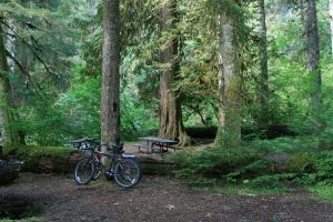
At 6.08 miles, (most online content will say 5.5 miles, but I believe in what the GPS unit says, 6.08 miles…And, the complaining my legs did, as well…) you reach the Dosewallips walk in CG, and I was right at first sight impressed. A large grassy field spreads out before you leading to the banks of the river, and you can still tell through the overgrown areas where the campsites used to be. There’s a pit toilet too, but the door has since been removed, and someone has fashioned a tarp for door…The road is still here, and it takes a bend and follows the river up. As we ride along, I’m fascinated, it’s as if the world had ended, and we are the last two left to witness what remains. The posts with numbers are still here, as are all the picnic tables, here under huge old growth cedars and firs. Everything is noticeably overgrown, giving it that eerie end-of-the-world feel. We find a tree thin enough in one of the campsites to lock up our bikes and begin our walking portion, I think at site #17. Originally, I believe there were 30 tent sites here, and it looked to be a fantastic campground when it was running full swing.
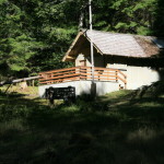
Soon we pass the old bathrooms, an outbuilding for firewood, we think, and a nice bulletin board warning you about the dangers of bruins and big cats, again, all covered in moss. The restrooms are in a long building with windows along the top of the wall and we can see conduit where power used to feed them. Just very surreal. I would have loved to see this place during its heyday, for everywhere we look; there are really nice campsites with fire pits and grates, near the river. The farther through the campground we walk, it becomes evident that this was probably a pretty good sized campground, and at the far end, we see the Dosewallips ranger station, complete with a nice deck at the front door. No matter how hard I tried to find old historical photos and information on this cool place, I came up with zip…Nada…Sure would love to see something from the past on this place.
The trailhead is just below the ranger station and there is a large billboard at its entrance. The trail starts out looking like a dry creek bed, obviously the rain has determined that this will make a good path when the water is flowing, but within a few hundred feet, you come to trail that is in great shape, soft with duff as it sits under the canopy of the large trees overhead.
“…and a small backpack on, carrying what looked like…a Samurai Sword? What???”
It continues easily upwards, on nice trail under the ancients. At eight miles, we reach the Hayden Pass junction, and stop momentarily to mark the junction on the GPS, when out of the corner of our eyes we see something large moving quickly down from the pass trail. Startled, we whip our heads around, and we both see something out of place, just from different perspectives. What I saw was two guys jogging, the lead guy without a shirt, and a small backpack on, carrying what looked like…a Samurai Sword? What??? And, his buddy, with a shirt, was also carrying in his hand a sheathed Samurai Sword. As they passed, I kept my eye on them, and then looked quizzically at Greg, “Did you see that?” And then I found out even more information, for Greg had noticed something entirely different. “Yeah,” he said, “they were both barefoot!”
So, between the two of us, we saw two guys jogging down the trail barefoot carrying Samurai Swords! I remember looking around to see if there was a film crew on hand and we had somehow stumbled onto a movie set.
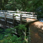
We take the low trail and in less than a tenth of a mile, we come to our first campsite, Dose Forks Camp. It’s located here on the banks of the Dosewallips River, in the clearings under the large old growth trees, next to the river. There appears to be several sites to choose from here, and then you get across the river on a massive wood beam bridge, the laminated beams that span the river must be close to 5 feet thick! Very nice bridge here at 8.2 miles. Across the bridge, the trail continues upward through more forest, this time the ground cover is huge fields of Salal that lines either side of the trail.
You reach another bridge in a little less than a mile, at 9 miles, and this one spans a slot canyon, and looking over the railing from the middle of the bridge will surely elicit that butterfly feeling in the pit of your stomach, as its way the heck up! We estimate it must be close to 80 feet up off the West Fork surface! Instead of being wood, though, it appears to be steel I-beams with a wood deck. Pretty amazing and clear that it must have been airlifted into place.
Once across the bridge, you’re back into old growth in short order and it becomes a nice forest walk heading slightly uphill on good trail. We settle into that pace that just wants to get somewhere, each guy kind of lost in their own thoughts once the conversation dies down, and it’s just putting your head down and getting down the trail. It’s a nice forest trail, but after about 10 minutes I’m bored, and I sweep the forest floor for anything interesting, like mushrooms and critter tracks. There are a few mushrooms, but not the tasty morsels I’m looking for.
At 10.8 miles, we come to a named campsite, complete with a wood sign that lets you know you’ve reached Big Timber. Why, yes it is! It too, is situated under big timber, old growth that blocks out what little vestiges of sunlight are overhead. Nice soft duff and fir needles await the weary traveler here, and it’s close to the river. In fact, all along this hike, the sound of the river is never far away, keeping you company as the trail rises and falls and dodges the edges when the river has eaten into the banks, or created obstacles too difficult to keep the trail close by. After this camp, it’s time to settle back into our mindless trudge, and walk through forest carpeted in thick lime green moss until we reach another campsite, Diamond Meadows, at 13.23 miles. There are a few campsites here and bear wire, too. In fact, most of the sites we would see here have bear wires, a fact that for some reason escaped us, for we brought a bear canister. There’s a small meadow here, and because of the name, I’m left wondering if its diamond shaped…
The trail stays relatively flat along this stretch of the river, then you reach your first big crossing in a half mile, at 13.7 miles. It’s clear that there must have been some kind of foot log bridge here as you can see old trees that have tread paths cut into the bare log, but now, it’s just a jumbled mass here along the river’s edge, a big debris pile of stacked logs and root balls. There is one log still spanning the gap, though, and you can see where someone has put a cut chunk of tree under it, to kind of prop it up. It’s not a tree of large girth, so it has a nice dip in it, no doubt the reason someone had tried propping it up with a stump to keep it from sagging…This is the way we choose to cross, instead of fording, in an attempt to keep our feet dry. That, and being lazy, we don’t want to shed boots, cross, then put everything back on… Its’ a bit of a balancing act, and as the bark less tree is wet, you get a little concerned, wondering if its slick. I go first, and make it across to the opposite bank without sliding off, where you have to pull yourself up the hill on the other side, through branches that are bent on trying to pitch you into the water…
“Oooh…Hey, Greg, are you ok?? Say, can you do that again? I want to make sure I got that on tape…”
Safely on the bank, I turn to watch Greg make the crossing, with camcorder in hand, because, you know, I have to document our trip…That, and the fact that it might make for some interesting video if Greg takes the plunge…You know…I’d help right away if that happened, of course! “Oooh…Hey, Greg, are you ok?? Say, can you do that again? I want to make sure I got that on tape…”

We both continue on, not having taken an early dunking. Again, we fall into the trudge mentality, putting one boot in front of the other and just walk, mulling over whatever enters our mind to keep us occupied, whether it be some problem at work, a silly song that gets stuck in your head that you’re trying your best to not have constantly repeated over and over again in your mind like a broken record, some sore spot on the pack that’s doing its best to beat your down or rub you raw, “hey, look, squirrel!” The miles pass…
About 14.7 miles in, the trail has to start climbing upwards a little more insistently, as it breaks out into the open, and must hug the ridge, being cut into a steeper slope and just above the river, as it tumbles down between the narrowing slot here. We can now look across to the eastern flanks of Mt. Anderson. For the next mile, it goes along this slot, and there is a huge section of trees that have been flattened, all tipped over into the river. Looking back up the slopes of Mt. Anderson, you can see where one monstrous avalanche must have come down the hillside, flattening everything in its path. Thankfully, the trail crews had been through here with chain saws and sawed off the ones that had been across the trail.
Finally, we reach the top where the river kind of flattens out, and there are campsites here under the forest canopy at 15.7 miles in…There’s a bear wire, and a sign point to a ford. Could this be Honeymoon Meadows, the campground that we had strived to get to??? A let down, to be sure. I was expecting more. Where’s the meadow??? There must surely be more to it than this…So, Greg scouts ahead real quick, crossing the river here, and comes back in a few minutes. “Yeah, there’s a meadow up here all right, but I don’t see any more campsites”. Reluctantly, I cross the river to join him, getting my boots even further wet, (again, being too lazy to pull them off), and we walk across the meadow in search of better digs. Curses, Foiled again. It looks as if those sites we passed there under the trees are indeed, Honeymoon Meadow sites…Sighing, we trek back and this time try the ford that the sign had pointed to, but that we had ignored as the river crossing right by the camp looked shallow enough…This is a better crossing, as someone has made stepping stones over the shallows here so we can hop from one rock to the next to get across without getting the tootsies too wet…
“…We no sooner get the tents up, and here comes the rain…”
And, there on the banks after crossing, is a wide open, sandy/gravel flat spot that will hold our two tents with no issues! Perfect for draining it looks like to us, as a dark, mean looking cloud is coming up the valley behind us…We no sooner get the tents up, and here comes the rain. I was beat, I just wanted to sit for a bit with the pack off and enjoy that, but, noooo…The weather had other ideas. It drove us into the tents as it started raining at a good clip, and kept at it for about two hours, including some hail…
The nice part? With camp all set up, lying in our tents, on the nice soft sleeping pad; it wasn’t long before we both were snoring softly…After the rain seemed it had played itself out, we crawl out of wet tents to get water so we can eat. Who knows when it’ll start raining again.
The nice thing about this site, other than it had a nice flat spot for our tents that looked as if it would drain well, was a fairly open view up Mt. Anderson, and a large hanging waterfall cascading down the cliffs, visible between the thick trees that were growing up to the bare steep rock. This, all across the river, and the meadows on the other side. While Greg was pumping water, I looked up, and white patches caught my eye. “Hey, look, mountain goats!” We could see about 3 or 4 plying the rocky hills above the meadows. Binoculars confirmed what we were looking at.
Done with dinner, we sit up for a bit talking about the day and what would be next, then a little nip to take the edge of the approaching cold night, and off to bed.
Thank you! And, I suppose a thank you to borvest inkral is in order, too? Is this a community forum as well? I notice there are different e-mails attached to it…Anyway, as far as community forums, no, i’m not aware of any, I know that I had some difficulty sometimes getting information on different hikes that I was interested in, so I decided to create a site that listed the places that I had been to, and what I thought about the conditions, views, etc…Again, thanks so much for the nice reply!!