Day 3
8 miles, 2500ft gain/2500ft loss, Fitbit steps: 25,332 We get up at 6, and are astounded at the brilliant bright red orb in the low horizon directly across from us, and scramble to get pictures of it. At first, I thought it was the moon, glowing blood red from all the fires over in Chelan, but it turned out it was the sun! When we looked back over our shoulder, there the full moon hung, still easily visible in the morning light. Can’t recall ever seeing anything quite like this, where you could look to one section of the sky and actually look at the sun without it making you squint, and then look to another section, and see the full moon? Someone made a quip about hoping it wasn’t a portend of doomsday, but the nervous laughter that immediately followed assured us that it was just a joke….Right??
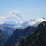
Anyway, of course, we couldn’t get the sun at that precise moment, for as soon as we broke out the cameras, it hid away like a shy kid ducking behind moms apron strings, so those pictures turned out to be a disappointment. Still, we have the memory…You’ll just have to take my word for it, it was cool!
“…It appears that there are individuals that drive this road as if it were a Pikes Peak Road race…”
We packed up after our morning coffee and constitutional, and drove down the bone jarring road at a snail’s pace to the pull outs by the Yellow Aster butte for our next day hike. A word of caution, though…It appears that there are individuals that drive this road as if it were Pikes Peak, and are attempting to shatter the world record for time…Twice, as we approached a blind corner, someone was coming around in waaay too big a hurry and if not for the fact that we were driving slowly, there would have been an opportunity to swap insurance information…
Safely at the Yellow Aster Butte trailhead, we unload and head out, and this trail heads uphill in earnest, so again, we’re glad we started early before the sun gets turned up, as it switchbacks uphill in the open until you finally reach the trees. The trail stays in the trees until you reach a small open meadow with campsites available, at 1.5 miles in. Keeping with the trend of continuing up, it’s just another short .36 miles until you reach the trail junction that leads to Yellow Aster Butte.
Ok, here is why I thought that it would be an easy jaunt to take in both Tommy Hoi Lake, and Yellow Aster Butte. As I sat on my Butte at home in my office, planning all of this ahead of time, I could see, from the maps that I was looking at, that it was only a short side spur trail to top out on Yellow Aster, then come back to the trail junction at the top of this saddle that we could see from where we were at. All pretty straightforward and easy enough, right??
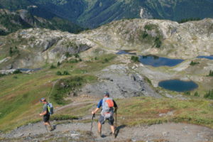
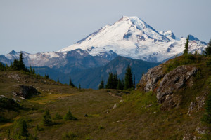
Clearly, here on the trail, we weren’t at the saddle that the maps showed the junction to be, but…Here was a pretty obvious trail with an even more obvious sign pointing the way to Yellow Aster Butte. Hmm…Well, having seen this kind of discrepancy before, who were we to question, so we followed this route that seems to side hill around the edge of Yellow Aster Butte. It’s nice in the fact that it’s in the open, and we have great views of Mt. Shuksan, and Mt. Baker later on, and it stays a gradual uphill all the way for the next 1.87 miles until we reach a promontory overlook that sits high above a small chain of shallow lakes here in a valley. Very cool, some of the bodies of water even sit in scooped out hollows in the rock, and there are connecting trails between them. We can see several campsites set up around some of the lakes, it looks like a great place to come and camp, then use as a base to explore the nearby mountain tops. This is about 3.8 miles in from the main TH. At least, we get to see some great sites, but we’re no where near our intended destination yet…
From here, its straight uphill on what looks like a goat trail to reach the top of the peak that we’ve been skirting for the last hour or so, and we decide to head up it. There is no tree cover here, just a bare slope except for some grass and low growing vegetation that covers the dirt. There appears to be some wildflowers in the mix, too, but they’ve long since bloomed out, so now everything’s just kind of a dirty green color. Now, we’re on top of a flat topped butte, but still not on Yellow Aster…
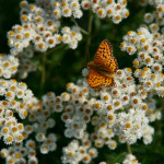
There appears to be no name for this round mound, but it does have a top, and it does have a surprise for us. To date, the bugs on this hike have been tolerable, very few mosquitos and a few biting black flies, but that’s it, nothing that makes you run for the bug spray really.
“…It’s an all- out aerial attack by…Ants! Flying ants, bajillions of them, mostly aiming at your head!”
Then, we top out on this nameless butte, and … It’s an all- out aerial attack by…Ants! Flying ants, bajillions of them, mostly aiming at your head! It’s unnerving, as they come at your eyes, mouth, nose, back of your neck, ears…I try to take a video of the panorama of the area, and have a hard time moving slowly for more than 15 seconds, as it’s too much to suppress the overwhelming desire to flail away at them like a raving mad lunatic. Stowing camera gear we beat a hasty retreat off the top. Two days later, I swear, I blew my nose, and found one of them…This place will forever be known now to us as Angry Ant Butte, not to be confused with Yellow Aster Butte…Are the Yellow Asters as fierce about protecting their namesake mound? A question that, for us, goes unanswered, as we decide to turn around and head back. We’d like to reach the car by noon or so, as we still have a 5 hour drive ahead of us, and Greg and I have to go to work tonight…
On the way back down, we pass two fresh day hikers on their way up to the top, and they ask if the view is worth it. “Oh, sure, it’s worth it, the views are spectacular!” Leaving out the part about the angry, insistent, dive bombing, ant hordes..
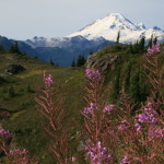
Still, we’re not lying about the view, for from the top you have clear views of Mt. Baker, Mt. Shuksan, and Tomyhoi Peak and its attendant lake, Tomyhoi. We didn’t at the time realize we were looking at it, but there it sits, in between Tomyhoi Peak, and Mt. Larrabee.
“…and gives us his in depth review of the facilities…”Nasty”…”
We make our way uneventfully back to the truck, and Dan stops to use the pit toilet here at the trailhead, and gives us his in depth review of the facilities…”Nasty”…
Burgers and beer are on our mind, so we load up and head for Chair 9, a local favorite bar and grill in Glacier.
Another successful hike, methinks, and really now that we know the errors in the TOPO on the trail to Yellow Aster Butte, and the Mad Ant Farm, it would be a great place to hike to in its own right, the lakes look like great places to camp and explore the nearby region. Mt. Larrabee and Mt. Winchester, too, were worthy day hikes, especially if you use Twin Lakes as a base camp like we did. On a clear day, the views are unparalleled.