Ranking: 5/5 Yep! It’s that good! I cannot imagine seeing so many impressive mountaintops, gaining access to climbing and world class views even for the tennis shoe crowd as there is here. Glaciers, hanging waterfalls, views down two river valleys, lakes, and peaks too numerous to mention, that this hike must be on everyone’s short list, trust me.
Difficulty: 6/10 Getting here is not as easy, perhaps as some hike beginnings, partly due to its remote location, and the road getting here is narrow, and one lane in places. The “facilities” are definitely primitive, but do not take away from what you will see when you get here, neck craning views of peaks so rugged you’ll be in some doubt as to where you just drove to…The trail is easy to follow, and switchbacks up the hill some 2.6 miles, before becoming a gradual climb to Cascade Pass, 3.3 miles in. This is where several of the afore mentioned “tennis shoe” crowd come with their families to drink in a superb view. Continue uphill steeply from here on the Sahale Arm trail to the 7600ft mark at the base of the Sahale Glacier, and climbing base camp, and you will be rewarded with views that are unmatched almost anywhere else in the country…The pictures I’ve included here simply do not do these rugged Alps style peaks justice.
Getting there: Take I-5N to the town of Burlington, and then take exit 230 for WA20E, Burlington/Anacortes/Skagit, and turn right onto WA-20E and go a short 350 yards before making a hard left. Continue to follow WA-20E signs through town, in .4 miles you will make another hard right. This is WA 20E/Cascade Highway, and you will follow it 45.7 miles to the town of Marblemount. Just past the Buffalo Run Inn and Restaurant, you’ll take a right at the sweeping left turn, across a steel girder bridge. This is now the Cascade River Road, which you will follow for 23 miles to its end.
Permits: 5$ per car per day, or a Northwest Forest Pass to park at the trailhead.
Maps: Green Trails map #80, Cascade Pass, or a PDF that you can download from the North Cascades Natl. Park website, Cascade Pass/Sahale Arm Trail.
Sahale Arm GPS Added 11/15/2012
Our second journey takes us to the heights of the North Cascades, in the National Park itself, to the trailhead for Sahale Arm/Cascade Pass, but since it’s such a long drive to get to the trailhead from our homes, we decide to get there a day early, and find a spot to camp close by, so that we can get an early jump on the trail in the morning…
Day 1
Leaving home, we pile into Greg’s truck with not only our day hike gear, but also overnight “car” camping, (complete with lounge chairs and firewood for an evening fire), and head north to find a place for the night. We find that there are only a few options left, since this is the summer vacation season, and many of the campgrounds are full, but as we continue up the Cascade River road, on the way to the trailhead, we find a nice campsite at Marble Creek, and set up camp.
Staking our spot, we now tend to the next urgent need, the filling of growling stomachs. A quick drive back to the town of Marblemount, and we find the sustenance we’re craving at the Buffalo Run Inn & restaurant, in the form of Buffalo Burgers. Never had one before, and neither had Greg, but we both gave them high marks for taste. Really, if they had not told you they were buffalo, you might not have been able to tell…Hunger satiated, we drive back to camp, and relax around a campfire whose smoke helps keep the bloodthirsty skeeters at bay, before falling asleep in the chairs as day turned to night, listening to the fire crackle as it slowly died down…
Day 2
3966ft gain/loss 11 miles. We break down camp, and get on the road, eager to start early on the trail, for the weather report says it’s supposed to be nice today, and neither of us really wants to swelter under the afternoon sun as we’re hiking up trail, exposed to the full rays of a summer sun. From Marblemount, the Cascade River Road dead ends at the parking lot for the trail, and it’s 23 miles from town.
“…Or, can we expect a total lack of civility, as we pass another car?”
Once you’ve entered the North Cascades National Park boundary, the road narrows, and you’ll pass the occasional sign that says, “Caution, primitive road ahead, no warning signs, one lane road, use turnouts as available”. Primitive roads? What constitutes a primitive road, the fact that there are no longer signs telling you what the speed limit is, or how fast to push the next corner, in gravel? Lack of Guard rails? Or, can we expect a total lack of civility, as we pass another car? What? We drive on, looking for signs that, “Yep! This here’s a primitive road, allright, dude totally forgot to use his turn signal, did you see that?” We did pass a 35mph sign, and we pointed at it accusingly, “Ah-hah! There is too a sign! Primitive road, indeed…” Or, something like that…We resisted the urge to uproot the offending sign, daring to encroach upon this primitive road.
“…while torturing us with its famous miserable weather at the same time…”
The road truly does narrow, the closer to the parking lot you get, and we arrive, disappointed, in the midst of a heavy gray fog, that has completely draped itself over everything, even sleeping climbers in their now wet vehicles. I try to keep the tone of sarcasm out of my narrative on the camcorder, as we prepare gear in the socked in parking lot, but this, I fear, I failed at as well…Have we once again been foiled by the North Cascades? It seems it always wants to hide, while torturing us with its famous miserable weather at the same time…Well, we’re here, and there is that promising weather report, so, nonplussed, we hit the trail at 8:20am.
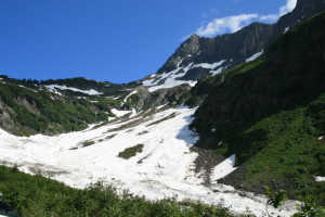
The trail starts in earnest, heading up, and for the first 2.6 miles, it’s a constant switchback through old growth trees on sturdy trail. According to the NP website, this is the most popular trail in the park, and the constant foot traffic that it receives is evident, as the trail is well worn by many boots into the hillside. As we near the 2.6 mile mark, we are now treated to the ever growing patches of snow over the trail, but it’s still easy to follow, for the muddy footprints of travelers before us have left a dirty path through the white snow, like the trail of mud from the yard through the house of many a hungry boy on his way to the refrigerator…
“…You’re in the North Cascades, or the Twilight Zone, it’s hard to tell, with all the heavy, swirling fog…”
We see a large Grouse on the trail, and attempt pictures, but to no avail, as the fog layer is still thick and heavy . Now, the trail is starting to sidehill steadily upward, and the trees start to thin, and become smaller. We are aware that we are probably in an area of clear views, but with the fog, visibility is reduced to about 25 feet at best. Finally at the 3.35 mile mark, we reach Cascade Pass, the only way we’re able to tell, is the fact that there is a nice rock patio with a small wall built up, and signage pointing the way to Stehekin, and the toilet…No views available, sorry. You’re in the North Cascades, or the Twilight Zone, it’s hard to tell, with all the heavy, swirling fog. Snow blankets the immediate area, and thankfully, we have the GPS, for it’s hard to tell which way the trail went, other than a trail of footprints beating down the snow.
The pass is at 5380ft, so we’ve covered 1740ft of elevation so far from the parking lot. We head left, uphill, following the trail of footprints in the snow, for it seems that they are heading in the right direction, and our GPS unit concurs. We meet an occasional hiker heading down, and their voices are heard long before we actually see them, for it’s getting breezy now, and the wind aids in carrying their voices to us, announcing their presence. We pass in the fog, and ask them if it’s clear above, and they only shake their heads no…
Hopefully, this ever increasing wind will aid in blowing it out. By the time we are firmly on top of the Sahale Arm, a ridgeline that runs uphill through small meadows mostly draped in snow, the wind is urgent now, blowing so hard that we have to yell over the roar to be heard. And, it’s getting cold, as I’ve stripped layers to avoid sweating. It’s an odd sensation, being hot and sweaty from the exertion, but my hands have now grown numb from the wind and temperature.
“…like a wave of storm tossed waves crashing against a buttress…”
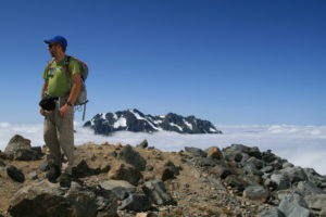
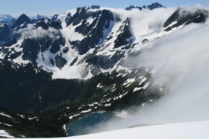
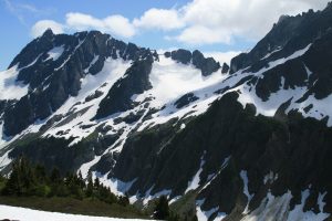
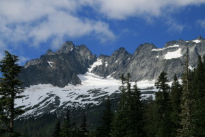
Finally, we see our first signs of clearing, and are able to make out the peaks across the Stehekin River valley from our position here on the ridge, and we are astounded. So, this is what we’ve been missing?! Amazing! As soon as we reach the 7,000ft mark, we now have clear views of the mountainous terrain around us, and it is glorious. Jagged peaks of granite as far as the eye can see, in varying shapes and pinnacles, massive peaks that seem impossibly stacked up one after the other, like a wave of storm tossed waves crashing against a buttress. It is truly a spectacle, with glaciers and massive snow fields clinging to them wherever they can gain a foothold.
“…the nearest has two tents sheltered here from the screaming wind…”
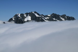
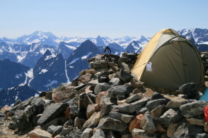
Following the snow downhill, your gaze is met with the green of the Stehekin River valley below, and once we finally reach the base camp for climbing now nearby Sahale and Boston peaks, we can see Doubtful Lake below us, sparkling in the sun that has finally triumphed over the waves of fog that are blowing up through Cascade Pass. To the west coming up through the valley we drove up to get here, the thick gray of walking clouds rush to the pass, and pour over the dividing wall of Sahale Arm that dives down to the pass, creating a river of fog that breaks up and dissipates once it reaches the west side. There, in the midst of the clouds, poking up above the layer is the majestic peaks of Cascade peak, the Triplets, and Johannesburg Mt, like a granite island in the sky. There are a couple of large knobs of rock protruding above the snow field here, and built like small castle walls of stone around the tops of these knolls are some of the sites for tents, the nearest has two tents sheltered here from the screaming wind that harassed us on the way here, but surprisingly, as we shrug off our packs to sit and take it all in, the wind is now calm.
“…and there he was, busily chewing on a pair of Teva Sandals, that looked a little worse for the wear now…”
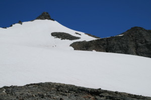
I break out my camera to take pictures of the peaks that jut impressively into the sky opposite us, and as I do, I catch something out of the corner of my eye, near the walled in tents. There, amidst the gear of camp, was a Marmot, perusing the climbers’ belongings as if he were shopping. I tried to get closer to get a picture of the little scamp, but he already slowly moseyed off, not too concerned about my presence, still not wanting me to get too close…After all, I might be the owner of said possessions! Then, I could hear the little critter gnawing on something, so with camera in hand, I rounded the wall, and there he was, busily chewing on a pair of Teva Sandals, that looked a little worse for the wear now…Snapping a few pictures of the busy little guy, I got closer so that he would leave, before the sandals were nothing but a remnant. I’m quite sure the owner of the sandals is gonna be a little unhappy when he returns. We can see 4 climbers on the glacier above us, and it seems evident that they are probably the ones that left camp here.
“…How can one not know that these collections of mountains existed before?”
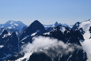
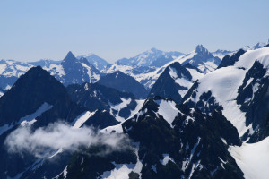
Its noon, so we take a half hour break before heading down. Sitting here at 7600ft, gives us a perfect view of the ridges, peaks, and glaciers opposite us, and I am intrigued by their shape and size. There, to my left, is a perfectly shaped sharks tooth of a mountain, and there to its right, is a tangle of ice, granite massifs, and spires that connects to another large snow/ice field, forming a bowl that rises sharply to the right, looking as if the top of the mountain here had been broken off. Behind them, are wave after wave of chimneys, peaks, and jagged granite that seem impossible, as if they stretch on forever. They remind me of holding up a large branch that had been snapped off a tree during a howling storm, holding the broken edge up against the skyline, so you could see every sharp edge silhouetted against an angry sky. How can one not know that these collections of mountains existed before? Where was all the print heralding their presence? Until you sit here, pondering how you could have missed these wonders, it’s hard to describe the feeling that you must be in a different part of the world, for surely you could not have missed them until now.
When I arrive home, I cannot wait to find the names of these peaks, and find that the name of the sharks tooth is Trapper Mt. (and hidden behind the sheer granite walls between us and it, is a large lake called Trapper Lake). The massif is Magic Mountain, (surely), and the broken top is Mix-up Mt. Hulking behind it, the top seeming large and fortress shaped, is Mt. Formidable. From the right shoulder of Mix-up , above the pass, and back towards the parking lot, west, is The Triplets, (named for the 3 distinct side by side peaks), then Cascade Peak, then Johannesburg Mt. furthest right, poking up above the cloud layer.
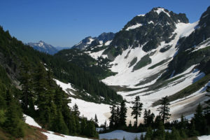
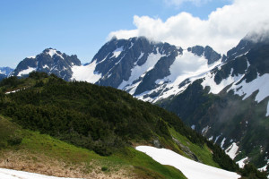
I could sit here for hours, wondering about how to get to the distant spires beyond, but…lunch is over, and we head back down. People are just now beginning to be visible on the trail below us, appearing out of the fog bank, and we’re glad we got an early start. Back down hill we go, and as we get to the meadows on the arm, (the upper reaches near base camp are bare stone, scree and talus fields that must be clambered over to get to the camp), we notice more and more of what we missed on the way up, as the fog begins to break up. Now, to our west, we can see down the Cascade River Valley, and the hanging glaciers from Johannesburg Mt. are now visible, as are the peaks on the Triad, and the massive glacier field radiating outward from Eldorado Peak.
“…we can stop and allow Dave his digital addiction, and it is a scratch that I must itch over and over and over again…”
I am stunned that we missed all of this on the way up and perhaps it best that I had the blinders of heavy fog on, for who knows when we might have reached the top, knowing full well that I probably would have stopped every 300 feet to stop and take a picture. Just ask Greg…Now, on the way down, we can stop and allow Dave his digital addiction, and it is a scratch that I must itch over and over and over again…My apologies, Greg-O! The closer we get to Cascade Pass, the more and more people we meet, and once we reach the pass, we see several families with their children enjoying the now wide open views in sunshine that were so evidently missing on the way up.
Back at the parking lot, you have to crane your neck to look up at the behemoths of granite that crowd the beginnings of the Cascade River Valley. Hanging waterfalls, and others, cascade down the granite cliffs, to feed the beginnings of the river, and huge snow fields still persist up the valley head towards Cascade Pass. Truly, it is a spectacle that is unmatched, and I urge you, if only once in your life, to journey to this part of the North Cascades, and see for yourselves that which I have trouble describing, for my obvious lack of descriptive adjectives is sorely lacking in describing a place so full of beauty and raw power.