Day 2
10.93 miles, 3326ft gain/988ft loss. Fitbit steps: 38,219 Yep, that’s right! We’ve entered the new digital age, as there is now an abundance of personal fitness gadgets out there monitoring your steps, calories burned, how well you slept, (I’m sure there’s a gap somewhere around 2:00am), etc. depending on the one you get. Greg’s got a Fitbit, so we’ll be tracking that info now as well.
After packing up, we drive the short distance to the TH, and are pleasantly surprised to only see one other car here! It’s still a little damp from the rains last night, but nothing bad. The skies are still swollen and grey with dark highlights, as if it might want to drop another round of showers, but so far they’re keeping their peace… We self-register at the box, and start off on the trail to Cutthroat Lake, #483 on the maps, around 8.
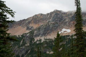
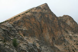
The trail is well maintained, relatively flat and wide all the way to Cutthroat Lake turn-off, at 1.95 miles. The way begins in tall trees and as you gain elevation slightly heading up, the trees thin some and you’re able to see some of the territorial views of the peaks that box in Cutthroat Lake. The peaks are jagged and colorful, mostly black with streaks of orange especially where the scree fields run off the mountains, like avalanche chutes.
From the junction to Cutthroat Lake, turn right, and you head uphill at a pleasant grade, with long swooping switchbacks that wind their way ever upwards. Again, the trail is in great shape, nice flat tread path, only occasionally broken up by roots here and there, or larger rock, probably where water has cascaded down using the trail as an easy route to the bottom. Most of the trail is covered in fine ground granite, like large sand particles, so it crunches pleasingly underfoot. Very nice trail, way to go, trail crews!!!
“…The jagged peaks look like blackened teeth sticking out of orange gums, like some prehistoric monsters gaping maw…”
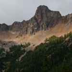
The higher in elevation you go, the alpine firs begin to get smaller and more widely dispersed to the point that the peaks on the opposite side of this large cirque of stone are constantly in view, and the pictures get better as you get above the tree tops. The jagged peaks look like blackened teeth sticking out of orange gums, like some prehistoric monsters gaping maw. Needless to say, on our journey uphill, as each new view presents itself, there is much picture taking…
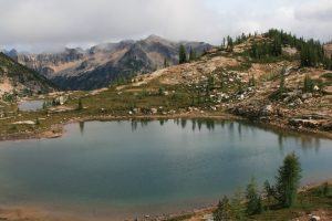
You reach Cutthroat Pass at 5.69 miles, and it’s a grand view from here. You now have bird’s eye view of Cutthroat Lake far below, encircled by trees, and gazing upwards from the lake basin, your eyes meet the orange scree fields that sit piled up like sawdust that’s drifted down out of the black saw kerfs that have been sawing at the sky overhead. Everywhere you look around this ring of mountains the scree is piled up along their base. It contrasts nicely with the green trees and blackened peaks that look as if they have been fire-forged.
From the pass, we notice that someone has posted a map outlining where fires have closed the portion of PCT from this pass towards Harts pass, thankfully, we miss the closed portion.
“…I end up stumbling because I’m transfixed by the endless peaks that are just begging for my eyetention…”
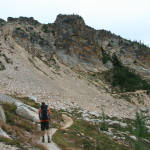
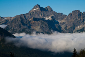
The trail continues to side hill the ridge, making it hard to remember to look down and see where your big clodhoppers are at on the trail, and several times, I end up stumbling because I’m transfixed by the endless peaks that are just begging for my eyetention… In .7 of a mile from the pass, we round the edge of another ridge, and are once again, treated to entirely new views. We can now look north down the ridge we will continue to follow down to Granite Pass, and Tower Mountain beyond. The cloud deck is still pretty low, I’m estimating around 7500ft or so, and it makes a nice line across the sky cutting off the top of the tallest peaks. Still, we can make out Tower Mountain although its top is clearly cut off by the clouds. We won’t know just how impressive this monolith is though, until the following day…
Also, from here looking more NE you look across tree lined Pine Creek drainage to the Needles, also almost completely obscured by low lying clouds. Well, we console ourselves; perhaps the weather will be better tomorrow…The ridge continues its run-out for perhaps another .75 miles, and then begins a descent on constant switchbacks down to Granite Pass.
From this point along the tip of the ridge, before beginning the descent down to Granite Pass, we can now see approximately where we need to go for our turn-off up to Snowy Lakes. There’s another tree lined valley that bends to our left, the Swamp Creek valley. High above the valley floor on the north side of the ridge, you can easily see the PCT and where it crosses over the ridge at Methow Pass. There is a small meadow that sits at the base of Tower Mountain and an unnamed peak right before Methow Pass. We’re sure that’s where the trail up must be. We take the switchbacks down to Granite Pass, another mile and about 600ft of elevation loss. Total mileage to here now is 8.06 miles.
It’s been a pretty easy jaunt up till now, and our legs still feel pretty good. Granite Pass is a small bench covered in alpine firs, and you can see that there are a few campsites here, some we can’t see as there are a couple little spur trails leading off into the trees here. Perhaps to a source of water we can’t see?? Before we left the top of the ridge above, we did see something glinting in the light, and with binoculars we could see they were solar panels, set on the ridge above and north of our current location, maybe a weather station?? Weren’t sure, but maybe one of these trails leads up to it? Don’t know…
“…It’s a long way to the valley floor…”
From this pass, the trail continues to head slightly down along the ridge we were looking at from the other side, always out in the open giving you spectacular views down the Swamp Creek valley and up to towering peaks on the other side. Again, I have to remind myself to look down every once and awhile, for a misstep here could be catastrophic…It’s a long way to the valley floor…
At 10.12 miles, we finally reach the little meadow that we could see back at the top of the ridge, and sure enough, we find a trail marked by a cairn that heads up what looks like a small creek drainage, but it’s still an unmistakable trail up, and we follow that up for .8 miles to the upper of the two Snowy Lakes. It’s pretty steep as it heads almost straight up and you gain about 620ft of elevation in that .8 miles.
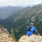
Once at the lakes, you’re treated to a wide open tableau. The first and shallowest is reached first, and it sits in the first of a two stepped bench. There are places where you can see people have camped nearby around either side of the lake. It looks straightaway down into the Swamp Creek valley below, and across to the peaked ridge on the opposite side. The banks are grassy and there is a sprinkling of larch trees about. Still our eyes are drawn up hill wanting to see what the next lake holds.
This one, the second and higher of the two is much more scenic, and you can tell it’s deeper, the color of the water a deeper blue color.
It’s also windier up here, and the gray skies coupled with cooler temps and what seem like constantly blowing wind, give us some pause. Would we be better suited at the lower, which obviously seems to be better protected from the wind that wants to sweep across the top of this higher bench??? Naw. We like the surroundings better. We find a little knoll with a few larch trees ringed around it, with a patch of dirt that has seen many a tent floor, and set up our 3 tents.
“…Somewhere, up there, are peaks, but we can’t see them…”
Lots of exposed granite here, worn smooth by the retreating glaciers of long ago, no doubt, and small copses of trees here and there. Lots of alpine firs mingled in with the larch grow all the way up to a small saddle at the top of the ridge between Golden Horn and Tower Mountain. All we can see of Golden Horn is the approach to its peak, a long seemingly perfectly flat slope leading upwards into the low clouds. Somewhere, up there, are peaks, but we can’t see them. Nor can we see the peaks that lie to the SW off the other side of this bench, from where the winds seem to be blowing…The valley floor here is home to the beginnings of the West fork of the Methow River. And, across that, you can see the steep cliffs of Mt. Hardy, but we still cannot see beyond it, or even the top of this sheer granite wall…
Still, it’s a pretty amazing view what we can see, and quickly set up camp after a short rest. Its right at 11 miles in, and we’re glad to have packs off. After setting up camp, we wander around taking pictures of the lake and surrounding area. We climb up on a rock on the north edge of the lake for a vantage point that takes in both lakes at the same time. It’s a nice flat ledge of rock with a slightly downturned edge towards the lake, so it makes a nice spot to kind of stretch out on after taking pictures. In fact, comfy enough for Greg to get in a cat nap, before a bad dream startled him awake…In his dream he was on the ledge, but then started slipping off the edge, needless to say it was a rude awaking, but also a relief to open his eyes and see that he was still safely on the rock…
Brian heads back to camp, and Greg and I give in to our wanderlust, after spying a saddle that doesn’t look too far away, cause you know, we just want to see what’s on the other side…So far, every time we’ve looked “on the other side” we’ve not been disappointed…Within 15 minutes, we’re at the saddle, and again are blown away by the view. We’re looking straight down into a deep slot that falls almost vertically down into another valley floor, looking like a boat keel it’s so perfectly formed on either side, trees leading down to the middle, of what is called Tower Creek. At the end, like a wall, rises the Handcock Ridge, at least what we can see of it, as the fog and swirling clouds do their best to obscure it all. Still, pretty dang neat. To the right of this low point saddle, is another almost vertical spire of rock, like a jutting chin from the ridge we’re on, its cliff face rising vertically it seems off the valley floor. Impressive. Everything here is colored orange and black, and this rock has some yellow moss growing on its side, adding to the color collage…From the top of the saddle its right at 7200ft elevation, and the bottom of the cliff face, before it starts to round out, is right at 6200, so you’re looking down a steep face of right at 1000ft…
“…my bail out, in case of a side wind, or me just being a dork and losing my balance is to the left…”
We continue to inch our way ever upward, hoping for the fog to break, that so far has continuously shrouded the crown of Golden Horn, and occasionally, it gives us hope, for it will lift for a short while long enough for us to see more clearly into the valley floor below, and the lakes behind us. Finally, it does almost completely break, and we come to a promontory of rock that juts out into the abyss.
It’s joined here to the main ledge with a narrow bridge of rock that on one side is a sheer drop off to the valley below, while to the right, there is jumbled rock over short, stepped rock before joining the next ravine to the left. So, to me, it looks like an awesome picture taking opportunity, and I gingerly walk out onto the joining ridge, and stand. I can’t look to the right for fear of developing a severe case of vertigo. My bail out, in case of a side wind, or me just being a dork and losing my balance is to the left. I might get scuffed up a bit, but at least I won’t tumble down to the bottom…Makes for a great pic, methinks!
After coming back in from the ledge, we make our way up a little ways more, and get a final, complete view of Mt. Hardy to our west, its top having been obscured by clouds all day.
“..Which, of course, only leads to more yelling, like, “Can you hear me now?!” and whatever else tickles us at the moment…”
Looking at our watches, we can see it’s time to head back to camp and prep for dinner. Just before reaching camp, on our descent down a rather steep talus field, I holler at Brian, for we had agreed that right before we made camp, he would walk over and stand on a huge chunk of rock about half the size of a bus, so we could photograph him in the middle of the two lakes. As I yell out, “Hey, Brian!” we laugh as we can hear the greeting echo about 4 or 5 times off the surrounding cliffs. Which, of course, only leads to more yelling, like, “Can you hear me now?!” and whatever else tickles us at the moment to hear over and over again…
Back at camp, we get ready for dinner, and film the first of what we hope are several field reviews of the gear we carry for the website.
Fog continues to swirl around the surrounding peaks, and through the valley below us, and we’re hoping that tomorrow we’ll get the chance to see what the peaks that are now hidden will look like. As night approaches, and it gets dark, we notice that we can see our breath now, and I’ve brought a small thermometer to let us know what the temps are. It was, according to the gage, right around 41 or 42. Pretty cold for mid-August.