Ranking: 1/5 Yep. A 1. Mainly, because we didn’t get there, and two…The effort cannot be worth the reward. Most of the way is spent hiking through trees and brush, over boulders, getting stung by hornets, etc. Think of this as a warning, unless you have self destructive tendencies, this hike is not worth the effort.
Difficulty: 10/10 A perfect 10…For all the wrong reasons…As I mentioned earlier, this is a grueling off trail scramble, I know the TOPO maps show a trail there, but trust me…A trail does not mean follow the general direction uphill, following a smattering of surveyors ribbons, over 11 miles up sometimes extremely steep trail-less ravines best suited for mountain goats…Hazards include, but are not limited to, stinging nettles, and angry hornets, boulder fields overgrown on steep slopes by tenacious vine maples, thick brush in any clearing that can be chest to head high, and the Box Canyon, which at times seems to be a class 3 scramble, needing assistance by grasping anything that protrudes above you, like rock, and tree roots. After 9 hours of beating the brush, we had only advanced 9 miles, and were done, 2 miles short of our destination. I’ve heard it said that there is an USGS hut overlook that staffs at times geologists to measure the ice of the Cascade Glacier…Strongly suggest finding the same way they got there…By helicopter…Consider yourself warned…Is it impossible? No. Is it worthy? Not in my opinion. The view CANNOT be worth the considerable effort required to reach this place… For once, I am inclined to believe what is posted in the Mount Baker/Snoqualmie National Forest website, for the South Cascade River Trial…(Trail was not misspelled, that was an on-purpose…) They describe it as “not recommended”. Good answer!
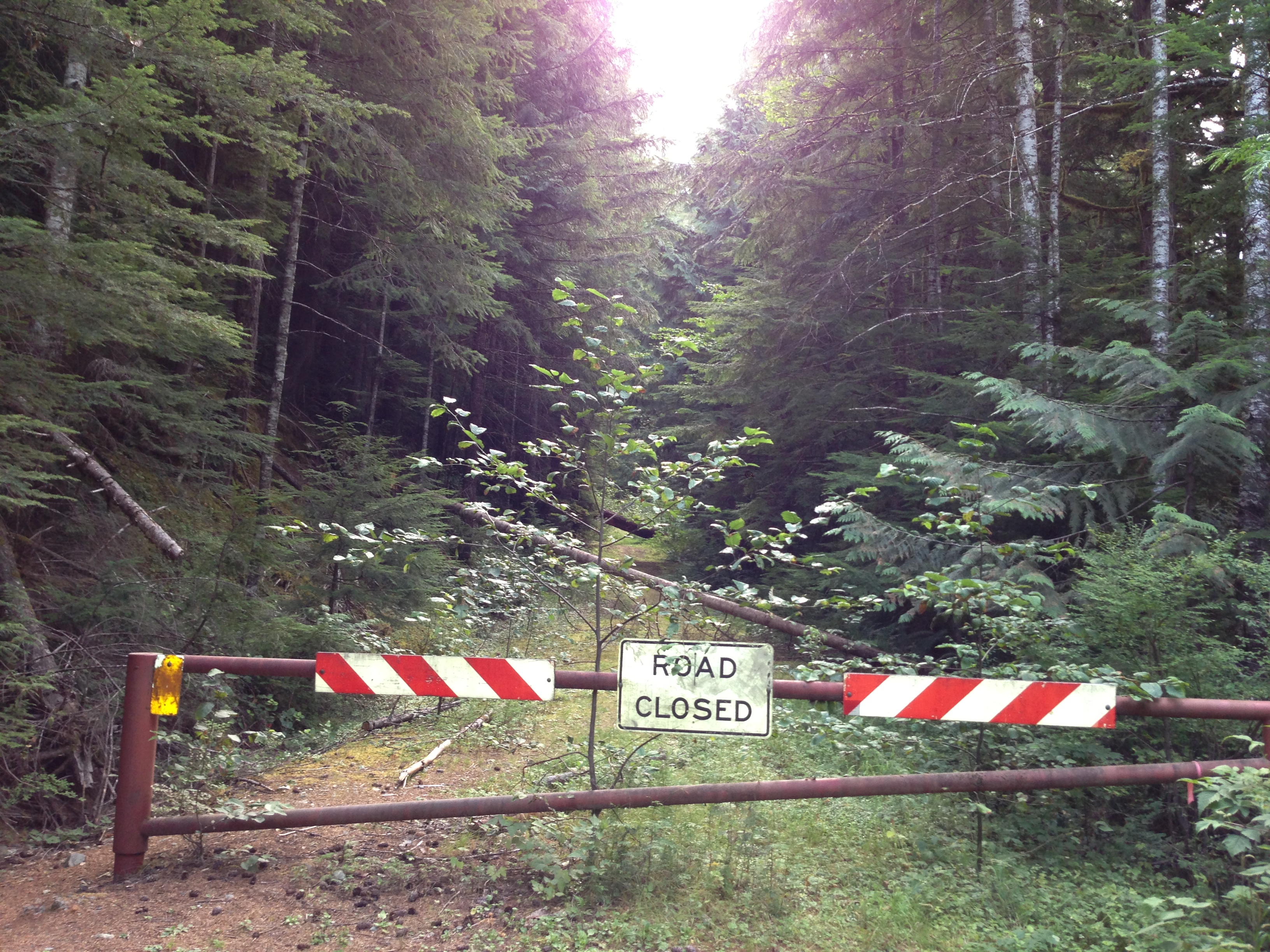
Getting There: Again, why??? But, if you insist…From Seattle, drive I-5N 64 miles to exit 230 for WA-20 towards Burlington/Anacortes, and turn right onto WA-20E, at the 0.2 mile point, turn left onto S. Burlington Blvd, then go 0.4 miles, and turn right again onto WA-20E, and follow WA-20E for 45.7 miles, to Marblemount. At the end of town, you will turn right onto the Cascade River Road, go across the Skagit River, and follow the road about 16.5 miles. Here you will see a gate across a road to your right, park here at the gate…
Permits: Northwest Forest Pass, or equivalent.
Maps: Green Trails Map, Cascade Pass, #80. Again, think of the trail here as more of a suggestion, than an absolute…
South Cascade Lake GPS Not Happening!
Today marks the first hike that our group numbers 5, and after this “little” hike, it may be the last…Not because I want a smaller group, but because that many may not wish to join me anymore, especially on a hike such as this. It all started innocently enough….
This time, Abby and Kipp would join us for this overnight hike, and we are glad to have them with us, and the remainder of the group would be Greg, Dan, and I.Truck loaded, we drive the nearly 3 ½ hour drive to the trailhead, and pile out, glad to limber up legs tired of being folded up in the truck.
Day 1
8.45 miles, 3977ft gain/2349ft loss.
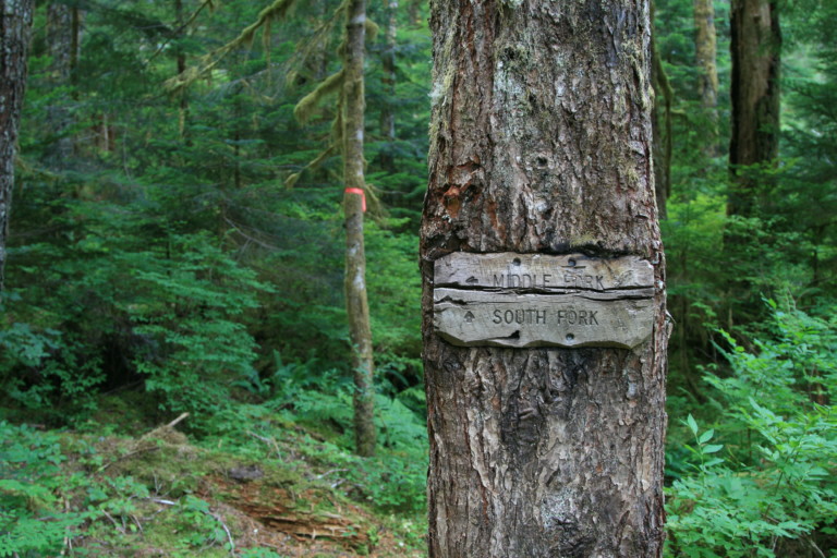
Submitted for your approval, Consider this the trail of broken dreams, along the River of Dashed Hopes…I hope that sounds ominous enough for a beginning… It all starts on an abandoned road that has not been maintained since 2007, when a large forest fire burned through the area, and a flood right after that took the road out. Still, following the road over relatively flat ground for the first 2.2 miles is easy. But, that quickly changes once you reach the only trail junction on this route. An old, partially ingrown wooden sign that points in two directions; one to the middle fork, and the other one to the south fork trail. Here, there is still a discernible tread path to follow, and we continue on, following the slightly overgrown path. I note here, that it is slightly overgrown, for it is still easy enough to follow, but that is quick to change, once we start following the river upstream…
“…until someone utters the cry, “Run, Forrest, Run!” and we all take off pell-mell down the trail…”
It doesn’t take long, before the trail becomes more of a trial, and from this point on, that’s what I’m going to call it, a trial… Soon, the brush becomes denser, hiding thorns and stinging nettles, logs have fallen across the trial, and we spend a good amount of time looking for ways over, under, and around the obstacles that seem to constantly rise up to stop us. Whenever we come to a clearing, the brush grows in abundance, doing its best to obliterate what small vestiges of trail remain, and it’s at about the 3 mile mark, we have a lot more to worry about than the stinging nettles…We stir up a hornets nest, literally, and the second person in line starts swatting at them, trying to get them off, and soon there is much yelling and swatting further down the line, until someone utters the cry, “Run, Forrest, Run!” and we all take off pell-mell down the trail. By the time the yelling and swatting and flailing around are over, the little buggers have stung and bitten everyone except for me, and the total hit count has to be close to 30…We erect a crossed X in the trail to remind us to steer clear of this trail hazard on the way back. I feel terrible, for I know that I was the first to step on the nest, which really ticked them off, and then they took it out on everyone else behind me.
“…large boulders spilled out down the hillsides towards the river like a rupture in a bean sack…”

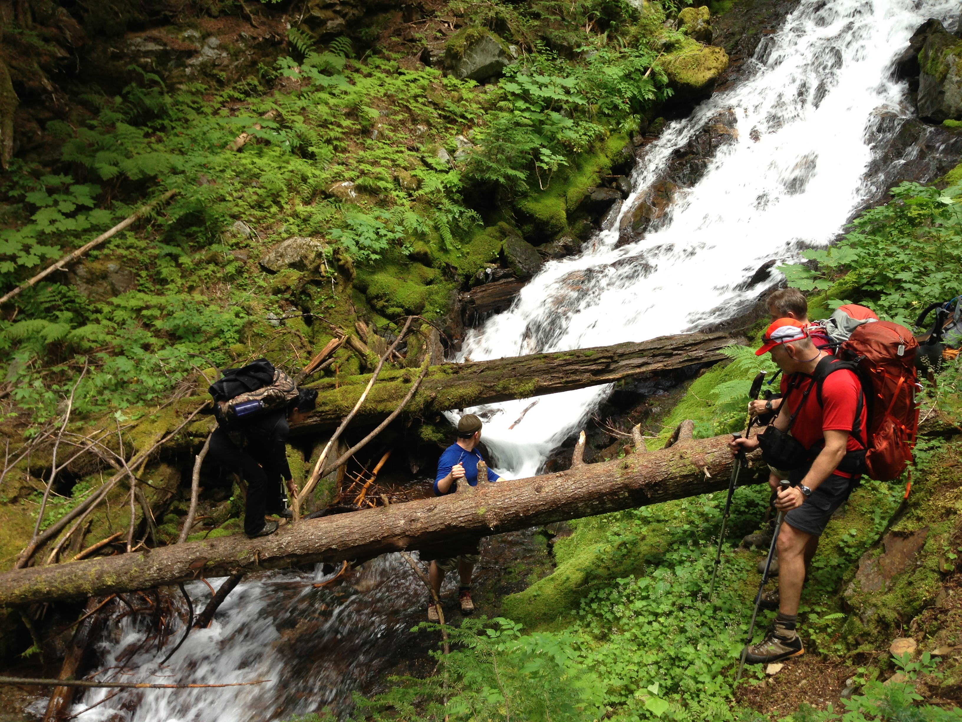
The first 4 miles go relatively easy, but after that, not so much…The trail has basically disappeared, and the only way to track it now are with

the occasional surveyors ribbon tied to limbs and brush, marking the way the trial used to go. I lost track of how many times we would enter an old avalanche chute with large boulders spilled out down the hillsides towards the river like a rupture in a bean sack, and whenever we would leave the forest canopy like this, the vine maples and other brush would do their best to cover the boulder strewn obstacle course. The maples are pretty in the fall, when their leaves turn scarlet, but to have to clamber over them as they grow across a boulder field?? Not fun. They did their best to trip us, grab at us, and try to outright throw us down with their branches and root systems, and we would curse them every time we entered another clearing. Several small streams had cut deep creek beds into the hillsides on their headlong descent to the river bed below, and many were filled with rushing water, forcing us onto narrow logs to span the gaps. Our pace continues to slow as the trail becomes more of a deep woods scramble, and by the time we reach Box Canyon, legs and knees are already cut and bloodied.
In the comfort of my chair at home, as I sat and planned this trip, I remember the elevation profile for Box Canyon raising my eyebrows, for it was steep, over a 1000ft per the .8 miles. Looked like it was going to be straight up, so I knew that it was going to be difficult after what we had already been through.
I remember telling everyone that as we approached the canyon, “Oh, by the way, it’s going to get steep”, but once we were over that, the worst would be behind us!
“…The elevation profile for this section is about 1200ft of gain over .8 miles!”
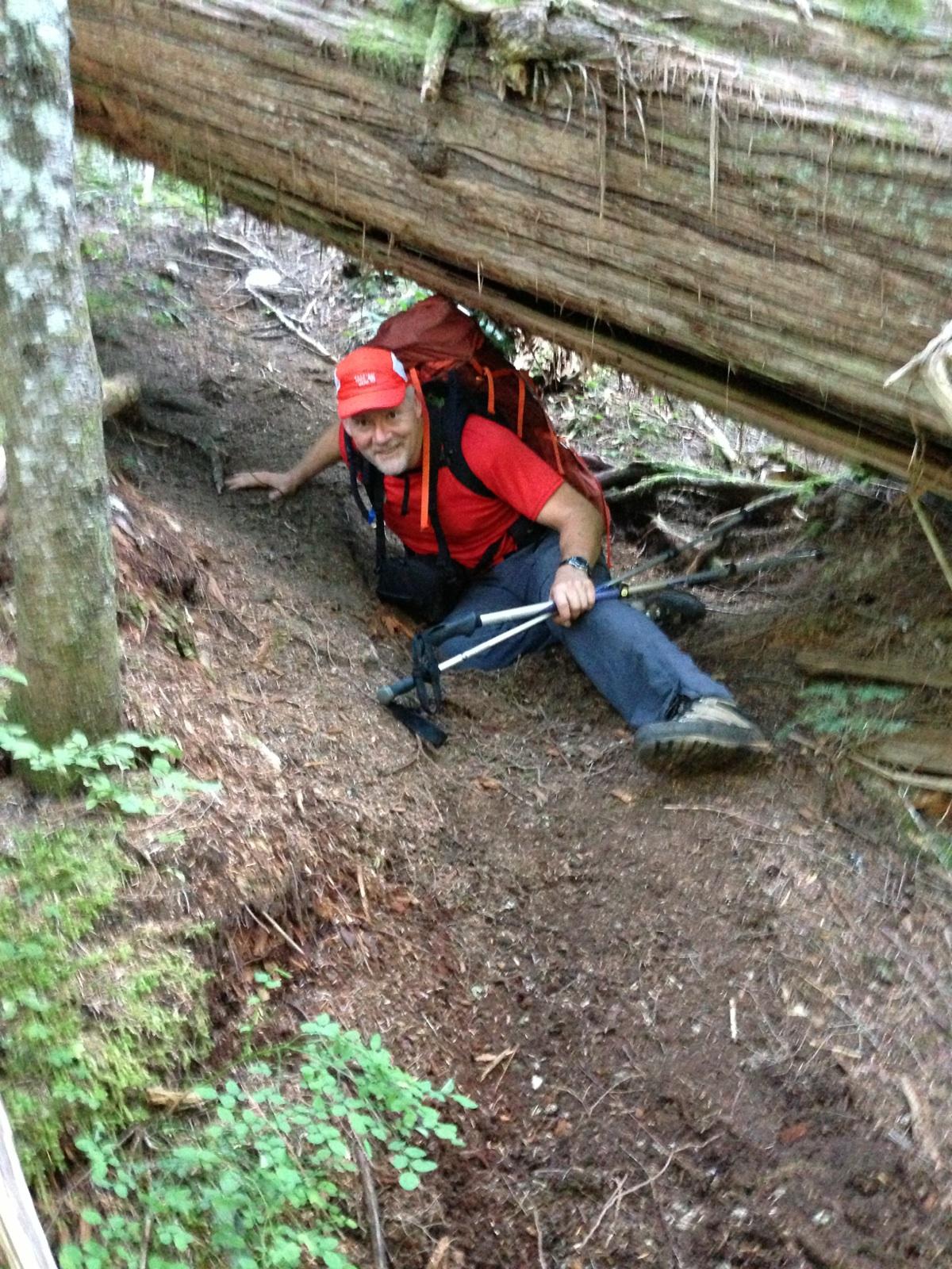
Box Canyon was indeed a butt kicker…The River follows its own course down the side of the canyon, and the way that was lined out for us, was incredibly steep. It was hard for me to imagine a trail ever having existed here, as we did a lot of reaching up to grab a root, branch or rock to pull ourselves up. Large fir and cedar grow here in this slot canyon, and if not for them, I cannot imagine there being anything to provide footing. Boulders the size of houses lay jumbled in here as well, and fortunately, there are ledges to get around on your way up, otherwise, I think it would be impossible to get through this way. The elevation profile for this section is about 1200ft of gain over .8 miles! Very steep!
After finally topping out, I hear someone mutter, “I never want to hear about Box Canyon again…” And, I’m sure the rest of the group could second that…
The way continues to wear us down, doing nothing but beat the brush, climb over obstacles, and look for the ribbons that now seem to be getting fewer and fewer, looking as if they too, had grown weary of marking the route. At around the 5:45 mark, when we’d been on the march for almost 9 hours in about 9 miles, we decided to call it quits, and looked for a flat spot to bed down for the night, so we headed for the river bank. There, we found a place that would fit 3 tents, and we set up camp, near water…
“…I felt fortunate as they were buzzing from a plant, not from the angry hornets…”
All anyone really wanted to do after that jungle expedition was sit and veg, but we forced ourselves to set up camp, and get water for dinner. My arms and legs felt as if I had electrified them, for they were buzzing from all the nettle stings. Still, I felt fortunate as they were buzzing from a plant, not from the angry hornets that has stung everyone else. Kipp’s knee had swollen the worse, about 5 or 6 inches in diameter, and red. He said he was having a hard time bending it to get over logs. Thankfully, Greg had brought enough Benadryl for everyone.
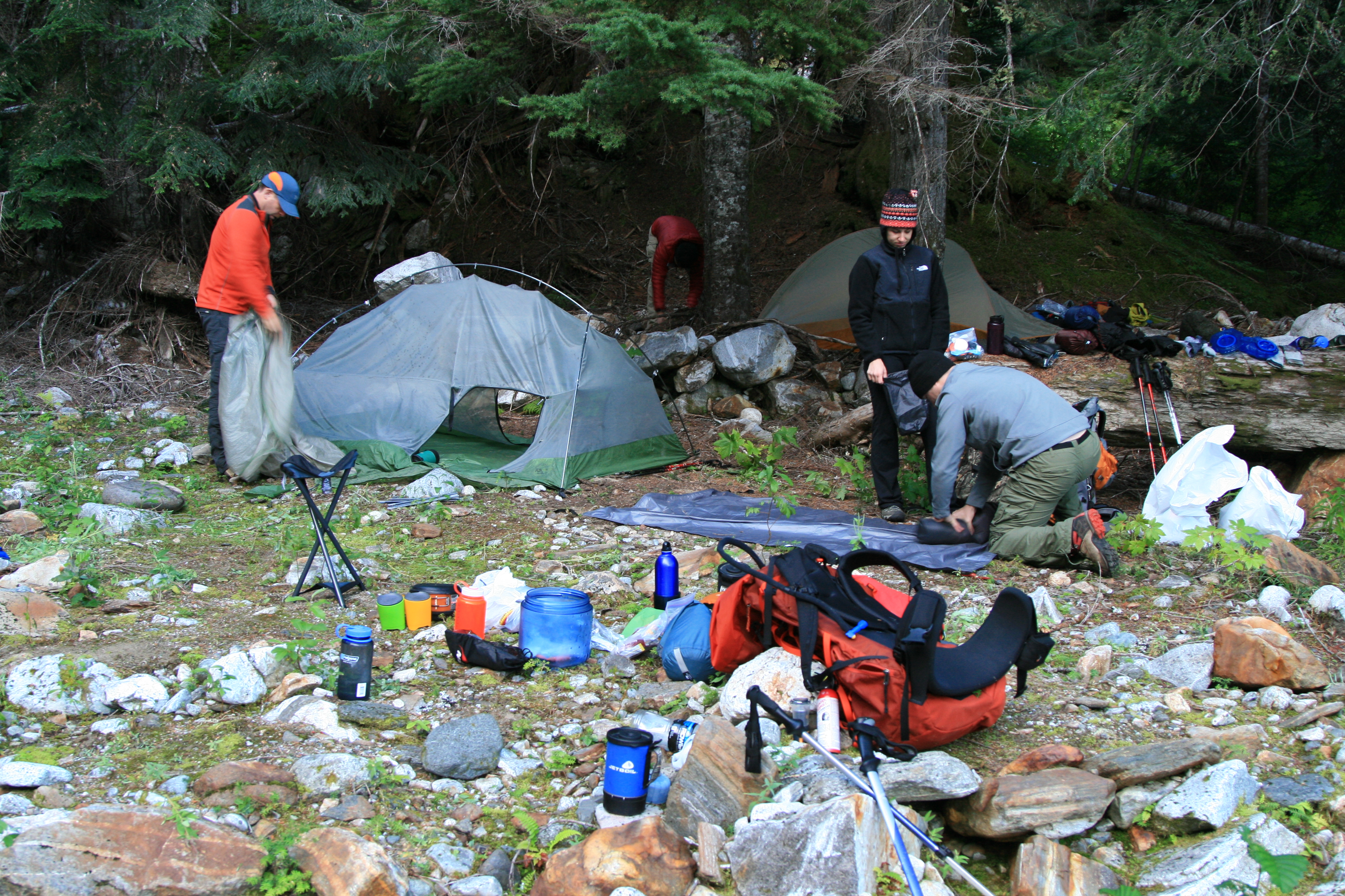
Dinner was again a favorite dish of ours, smoked salmon and angel hair pasta. We were supposed to have mashed potatoes to go with that, but…I had forgotten to bring them, so I just sat there staring stupidly at my empty Zip-lock bag…Man! How had I forgotten to do that? Even with a checklist, I still managed to forget part of dinner! Sure hope I made up for my forgetfulness, with a whole bag of nutter-butters…
Everyone was bushed, so we were all in bed by 9:30, and the constant roar of the nearby river, helped put everyone to sleep.