Day 4
12.6 miles, 663ft gain/3388ft loss. Up and out. Another long slog is ahead of us, so we break camp around 8:00am, and hit the PCT once more. It’s a great ridgeline hike, as we round the leading edge of the spine of rock that we’d been camped on, granting us wide open views south and SE from the trail. The trail is relatively flat, and follows the contours all along this ridge, bowing back in to a couple more unnamed tarns through thinly populated trees and Manzanita brush, then back onto the next ridge, this one more densely populated with firs, hemlock and some cedars now. Gazing between the trees, in the valley below us, we can see the green blue waters of Escondido Lake. It’s amazing how many different zones you will cross on this hike, from hot and arid, to meadows with marshes, then the shadows of large conifers and cedars. It seems to be not able to make up its mind, as if it has split personalities here.
“…By mile 3 we reach our first trail junction, and Dave gets confused…”
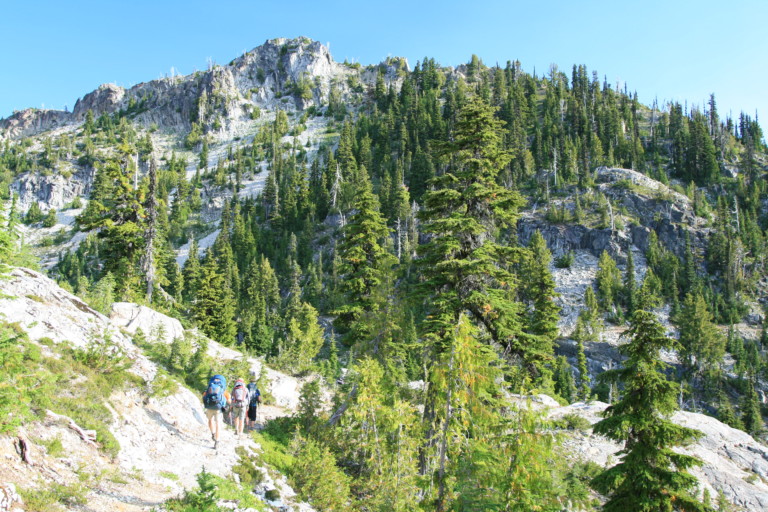
As we round the point of this ridge, we enter an area that has hillside meadows, the purple Lupine and golden yellow of daisies mix to make a sweet fragrance. There’s even a signed campsite here, in a meadow, also not showing up on any topo map. By mile 3 we reach our first trail junction, and Dave gets confused. You see, normally when I plan these routes, I make sure and note the junction with a POI, (point of interest) marker, and note the number of what trail we’re supposed to be on…But, I didn’t do that when planning this route, and just made the assumption that I would be able to figure it out on the trail…Well, that didn’t happen, and because of that mistake, we continued on the PCT for another .8 miles before it dawned on me that we had to be going the wrong direction, as we were getting closer and closer to Waptus Lake. That was part of the confusion for missing the trail in the first place. The route we should have been on, at that last trail junction was named Waptus Pass, and I just knew we weren’t supposed to be going to Waptus LAKE…I felt terrible…I had led us downhill for .8 miles the wrong way, adding mileage to what would already be a monster day…Back up hill we went, to the missed trail junction. Mental note to never plan routes again with the simple addition of POI’s….Sorry again about that nav error, guys….
Back on track, on the Waptus Pass trail #1329C, it’s readily apparent that this trail is not as well traveled, or maintained. It’s easy to trace, however, and continues leading us downhill to Waptus Pass. As we near the pass, the trail levels off, and leads us through several muddy marshes, old logs laid across the worst spots in a line to help you from sinking up to your ankles in muck. At Waptus pass, there was a tree that fell in perfect line with the trail leading back towards Pete Lake, almost obscuring it from view.
Our troop continues downhill along trail #1329, past the Escondido Lake trail, and across a tributary that will become Cooper River further downhill. At our 7.8 mile mark, (because of the 1.6 mile “detour”), we reach the steep slope above Pete Lake, and begin a knee burning .75 mile downhill, a set of rapid zig-zag switchbacks that on the map look like and ugly wound that was poorly stitched together. The trail on the upper part is very steep, dusty, and rocky, with few trees to shield you from the hot sun that’s now set to parboil. The loose rock here is varied in size, from baseball to pebble, all conspiring to do their best to trip you up. The knees and lower back take a pounding here. Finally, we reach the junction that rejoins us to the trail that will lead us back to the car, near Pete Lake.
“…Greg’s heels have become blister upon blister, making for a painful walk…”

There is a sigh of relief, for we know that the rest of the trail will be easy on tired bodies. Greg’s heels have become blister upon blister, making for a painful walk, and Dan, too has worn a large blister on one heel. That, and just the amount of mileage under a very hot sun, carrying heavy loads, can zap ones energy quickly. We pass a few horses on the trail, and a familiar face. I look up during this slog from the dusty trail ahead of me, and right into the face of the little guy we camped next to 3 days ago! You know; the one with the persistent questions and who let the dog out! It looks as if mom has joined them, and as I look forward, Greg has looked back and said, “That was the guy that was camped next to us!” I too, was surprised to see them, yet relieved as well, for surely that meant we were close to the trailhead.
Finally, we reach the parking lot and are quick to shed packs. As were milling around, trying to loosen stiff joints and just generally enjoying having the torturous boots and packs off, I happen to look to my right just in time to see a white Ford pick-up back into a car behind him, and then drive off! Hey! We jot down his license plate # and leave a note on the slightly spindled vehicle as a witness. To date, I’ve not been contacted by the owners.
Back in the truck, (without AC), we head for home…But, not before stopping in Cle Elum for a much deserved burger and shake! One of our longer two day treks, for sure, with big mileage only broken up by our day layover to try and tackle Summit Chief Mountain. Because of its remoteness, its not a peak that is climbed often, but in no way does that diminish its challenge for those just wanting to scramble a named peak, with such great views. If ever I get the chance, during a month with less snow, or with the right climbing gear for steep snow, I wouldn’t mind the challenge of attempting it again, and this time…I know the right way home!!!!