Ranking: 4/5 Another great hike in the Alpine Lakes Wilderness, and this one has something for everyone. Challenge to get there? Check. Peaks to add to your growing list of mountains climbed? Check. How about beautiful alpine lakes in surroundings that look other worldly? Yep. Do you want to get some great photos of Mountain Goats? Well, they’re here too. Like to fish? The lakes here have some trout. How about spectacular sunsets against dramatic mountain vistas? Believe me, this area has that, too!!! A beautiful alpine area that has few peers, for sheer amount of scenery.
Difficulty: 7/10.The road here is one of the worst I’ve traveled in recent years, including a stream ford that might be challenging to a low clearance vehicle. Lots of wash boarding and chuck holes in this rough and bumpy gravel road. Once at the trailhead, The first few miles are easy, until you reach the junction to the lakes, then it gets steep and rocky, requiring some large steps up and over rough terrain. After reaching Tuck Lake, the trail becomes nothing but a scramble in places, requiring you to follow cairns over bald and steep granite.
Getting there: Head north on I-405N towards Bellevue, and take exit 11 to I-90E to Spokane. Travel 70.5 miles to exit 80, Roslyn/Salmon La Sac. Once off the freeway, turn left, and drive 2.1 miles to your first traffic circle, and continue straight through another .7 miles to the next traffic circle, where you will turn left onto 903N towards Roslyn. Follow 903N through Roslyn and Ronald, for another 16.5 miles to pavements end. You will notice that about 4 miles outside Roslyn that the road becomes Salmon La Sac Road. At pavements end, the road forks, take the right fork uphill, on gravel. This is FR4330, which you will follow all the way to its end another 12.3 miles to the Deception Pass trailhead #1376. You will have to cross a couple streams, so it’s advisable to have high clearance vehicle, or plan on biking the rest of the way, or hiking in. The stream that seems to run year round, the Scatter Creek crossing, was almost 2 feet deep when we crossed in mid August, and it’s still 3.3 miles from the trailhead.
Maps: The Alpine Lakes Wilderness Map, put out by ALPS, is a good source, and making your own onTopo.com. Also, Green Trails Map #176, Stevens Pass.
Permits: 5$ per vehicle per day, or a Northwest forest Pass to park at the trailhead.
Tuck/Robin Lakes GPS Added 11/15/2012
The summer weather is holding! After such a cold wet spring, it’s great to know that we’re finally getting some great summer weather for our hikes, so once again, we take off to the Alpine Lakes Wilderness, to feast our eyes on more of what the area has to offer. Greg is unable to join us, so Brian and I trek this one together.
Day 1
6.2 miles, 2910ft gain. Since it’s relatively close to home, we leave early on Friday morning, hoping to get a head start on the rest of the crowd that is sure to visit this popular destination. The road here is rough, and a high clearance vehicle is recommended, especially as you cross Scatter creek. When we crossed over, (it’s a paved road over the creek bed, to minimize erosion, think of it as an underwater bridge), the water was almost 2 feet deep.
“…many boot prints have turned the trail to dust here…”
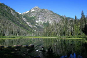
Finally, we reach the already crowded trailhead for Deception Pass, there must be over 20 cars parked here! Man, I sure hope all these people aren’t at the lakes; there won’t be any spots left to camp! We pack up, and hit the trail around 8:00am. It begins innocently enough, the trail is obviously well-traveled, and looks as if an army has gone up before us, many boot prints have turned the trail to dust here. It’s an easy, flat hike for the first 1.5 miles, where you reach the shores of Hyas Lake, a large tree enshrouded lake that has magnificent views to nearby Cathedral Rock, a granite icon that stands like a beacon jutting out of the ridgeline above the lake that can be seen for miles.
There are several campsites located near the trail that runs along this side of the shore, and it’s obviously a great day hike for families and anglers, for we can see many fish jumping here in the calm waters. Somewhere, between the car and near the lake shore, when we stopped to take pictures, Brian’s sunglasses decided to bail, and we looked around where he noticed they were no longer with him, and couldn’t find them …That sucked! Well, he’s gonna need some eye protection of some kind, so I offer my hat, in hopes that it will offer some relief from the sun that will be ever present on this hike.
Past the end of the lake, around 3.3 miles in, we start the uphill journey to Tuck and Robin Lakes. It’s a moderate uphill, that switch backs through old growth fir, filled with birds constantly chirping, providing the soundtrack for this section of trail. At mile 4, we reach the turn off to the upper lakes, and I must stop to take a look at my sore heels. From our hike two weekends ago, after wearing new boots, I created blisters all over my heels and tops of my foot, that now are once again insistent.
I was hoping that perhaps that last hike would have been the trick to breaking these boots in, but I find that so far, it’s not the case. More the boots are breaking me in…Moleskin applied to the hotspots, we continue on. Suddenly, the trail isn’t playing nice anymore, and in less than half a mile, it begins its bid for Tuck Lake by going straight up what I’m sure is a goat trail, to be kind. Loose rock, the kind that’s about the size of a baseball litters the dusty trail, and is a sure recipe for a twisted ankle, if you’re not careful.
“Still, their gnarled appearance makes it look as if they are all Methuselah’s…”
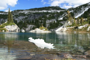
In places, you have to hang onto tree branches to steady yourself as you try and follow this thin wisp of a path as it continues its ever upward direction. Fluids are quickly leaving my Camelbak; the heat of the day, coupled with my exertion of high stepping over large obstacles and loose footing have me constantly reaching for the mouthpiece, sipping in ever increasing urgency…Finally, we reach the banks of Tuck Lake, and it’s a pretty, granite enclosed lake, with tenacious alpine firs clinging to the bald granite, wherever and however they can wiggle a root in to gain purchase. No matter how many times I see it, I’m amazed that they manage life here…Still, their gnarled appearance makes it look as if they are all Methuselah’s, having spanned generations of lifetimes as easily as if one crossed the street.
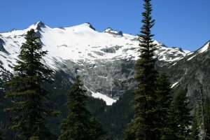
The granite here is criss-crossed in large striations and cracks, further adding to the impression that this landscape has not aged well with the passage of time. The rounded knob outcroppings at the outlet of the lake are great vantage points to stop and stare across the Cle Elum River valley far below that holds Hyas Lake and the trail we just hiked to get here. The object of our ogling now, is massive Mt. Daniel, a hulking mass of bare granite covered in glacier ice and large snow fields, that are draped across it like a cape, covering the shoulders, but not the lower half, allowing you to see small rivulets of water flowing down the crevassed granite for hundreds of feet. To the left of the top peak of Mt. Daniel sets Cathedral Rock, looking like a medieval knight’s helmet set aside. Of course, I break out the camera and camcorder…During our picture fest, we meet a guy that has come down from upper Robin Lakes, and he said that there was a large herd of mountain goats, around 30 or so. Great! Would love to see them! We part ways, and continue our upward battle, glad that we’re now only about a mile from the lakes!
From here, there really isn’t much of a trail, and we know that we need to stay to the right of Tuck lake for the best route up, but as we walk on what we think is the trail up, we lose sight of the lake, then reacquire it a bit later, continue heading around to the right of the lake, until it’s obvious that what we’re looking at is lowly Tuck’s Pot, a small offshoot of the lake itself. Dang it! A bit more bushwhacking, and we’re back on track. We’ll note that on the way back, and not be fooled again…
“…To say it’s a rough trail, would be a mild understatement…”
The trail is incredibly steep here, and reminds me of reaching the Enchantments from the Snow Lake side, as you need to follow cairns most of the way, and there are times when you have to set trekking poles aside to grab hold of whatever you can to pull yourself up to the next foothold, whether it be rock, root, or tree limb. To say it’s a rough trail, would be a mild understatement.
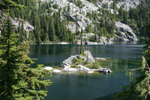
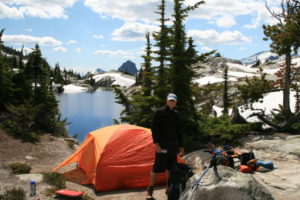
This last mile will take almost an hour, but once reaching the crest, and looking down into the Robin Lakes basin, your breath will be taken away once more, this time from the awe inspiring lakes below. Carved into the solid rock here, are two beautiful alpine lakes, the lower being the most scenic. The lakes are surrounded by sloping walls of solid rock, with a dividing ridge separating the two. This ridge runs uphill towards Granite Mountain, and has small pockets of trees and flat ground that provide excellent tent sites.
“…the only thing that seems to be missing is sprites and elves populating the shores here…”
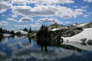
The lower lake is enchanting, for it winds around rounded bald granite, with small pockets of alpine trees and meadows, creating small islands of fancy in its crystal blue waters. Fish jump, water chuckles over rock at the outlet, and the only thing that seems to be missing is sprites and elves populating the shores here. As your gaze turns to look at the cleft in the solid rock that becomes the lower lake’s outlet, the view becomes majestic once more, looking more like a back drop painting than a possibility. Massive Cathedral Rock dominates the background, and all the jagged and pointed peaks in the distance provide stark contrast to the rounded and sculpted granite of the lakes region.
From the dividing ridge that separates the upper, and larger of the two lakes from the lower lake, you can even see distant Mt. Rainier. This combined with Cathedral Rock and the hulking shape of Mt. Daniel, against the foreground of the lower lake, is truly a spectacle to behold. Large Billowy white clouds lazily float by, casting shadows across the stark granite and reflective surface of the lower lake. It truly is captivating, and my camera whirs with a flurry of frenzied pointing and shooting, not wanting to miss or waste a single moment. We quickly head for the dividing ridge, wanting to claim our spot before others show up.
We only notice two other tents in the lakes basin, we’ve arrived in time! After setting up camp, we collapse exhausted for a few moments, swatting at the insistent biting flies that inhabit this otherwise perfect spectacle. It’s hot out but no matter…We slumber for an hour in the tent, a refuge from the swarms of biting pests that have now made themselves known. Time to filter water, and wander around taking more pictures of the area, as well as look for the mountain goats…Where were they? We had hoped to see them when we got to the lakes, but have yet to see any…No matter, dinner still needs to be prepped, and after an hour of wandering about, trying to capture that perfect picture, we set to work on getting our meal ready. After dinner, it’s cleanup time. The hours pass, and we notice more and more people wandering in, and at one point, a man and wife walk up to our camp, and ask if there are any more sites further up. We confirm that, yes, there’s a nice spot just above us, overlooking the lake. They thank us and set up camp, our new neighbors.
After dinner, Brian spies the mountain goats, but before I could get my camera out, we hear the barking….Incessant dog chatter, which chases off the goats. Just great! No matter, though, as later a group of goats wandered through camp, and we got some great pictures of them, including a young kid. It’s always nice to see the goats.
Later that evening, as we’re wandering around, the man waves at us, and invites us over to his campsite for cocktails. “Sure! Thank you, we’ll be right over!” Introductions are made all around, and we find out that they are Doran and Mary from Yakima. This is our introduction to back country whiskey sours, made with crystal light and snow, a great beverage on a hot summers day. We enjoy good conversation sitting on the rounded granite rock that slopes down to the waters of the lower lake, a perfect vantage point to watch the sun slowly set over the distant mountains.
“…creating the illusion that there was a hole through the world like a magician’s ring, allowing us to see the night sky on the other side of the universe…”
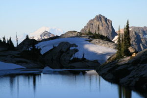
No words can describe the rapt attention that this will require, especially as the sun sets against this most impressive view, the alpine glow casting faint pink shadows on the now reflective white granite. On a clear summer’s night, we sat and watched the sun fade from view, and the evening stars reflecting off the surface of the lake, creating the illusion that there was a hole through the world like a magician’s ring, allowing us to see the night sky on the other side of the universe.
What further enhanced the effect that it was magic, was the occasional shooting star that would light up the sky in a moment of brilliance before quickly fading like pixie dust, its image reflecting off the lakes mirror surface, a double image that I’ve never seen before, nor do I ever expect to see again. One word to describe this warm summers night…Awesome. We thank our hosts for the drink and conversation, and hope to see them again the following night, when their family will show up in the late afternoon. Knowing we’ve got a big day, trying to bag two Mt’s tomorrow, we get to bed around 10:30pm.