Day 3
12.4 miles, 2864ft gain/2260ft loss.
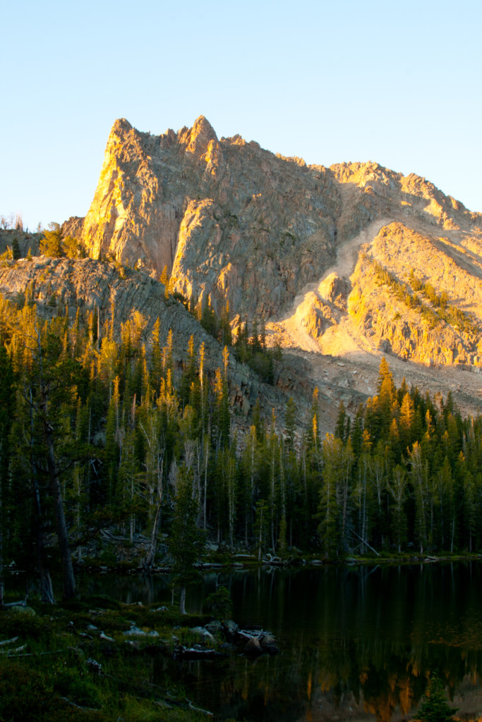
Another beautiful morning! Before the light changes, it’s over to the lake to see if we can get any sunrise pics. Not disappointed, for the large granite peak that sits just south of the lake, reminding me of a chieftains war bonnet is now reflecting the reddish orange glow of the approaching sun, its image being reflected in the lake. Only having minutes to capture the changing colors splashed against the already ruddy colored granite, it’s a furious race against time to click off as many shots as possible hoping for that one that will capture the right lighting.
“…a head pokes up and eyes me quizzically, as if to ask, “Did you take my mouse?”

The sun rises, and the opportunity passes, so it’s back to camp for breakfast. I head down to the outlet stream, to set on a well-placed log across the creek to pump water, and I notice a small mouse scurry my direction on the opposite bank, then dive in between a couple rocks, disappearing from sight. I thought he was hiding from me, when I saw more movement in the brush. At first glimpse, it looked to be a squirrel perhaps, but then at the end of the log I was sitting on, a head pokes up and eyes me quizzically, as if to ask, “Did you take my mouse?” It’s a Pine Marten, and he’s only about 8 feet away. He gives me the impression that he’s ready to scamper across the log to inspect my pockets for the mouse, so I start talking to him, not really wanting him to end up in my lap. I see more movement in the tree closest to the bank, and get glimpses of what must be his mate helping with the hunt. They don’t leave the area, even after I get up, bound and determined to catch their prey. At camp, I point them out to Greg. Really our first critters we’ve seen other than birds, chipmunks, and squirrels.
We break camp, and continue down to Willow Lake, and a trail junction at .7 miles to Frog Lake. We stay right to remain on the Boulder Chain Lakes trail. This leads consistently downhill to a meadow that the trail bisects, and I see meadow mushrooms and a few giant puffballs! If only I had found these yesterday near camp, they would have made a nice addition to our meal!
Shortly after passing through the flat meadow, the trail heads around a point on the ridge,and…Just like that, the entire ecosystem changes. We go from alpine fir, pine and typical arid forest like you see on the east side, to Aspen, sage, and open grass growing on steep hillsides, this place continues to amaze!
“…Again, a massive spectacle that cannot be captured accurately with cameras…”
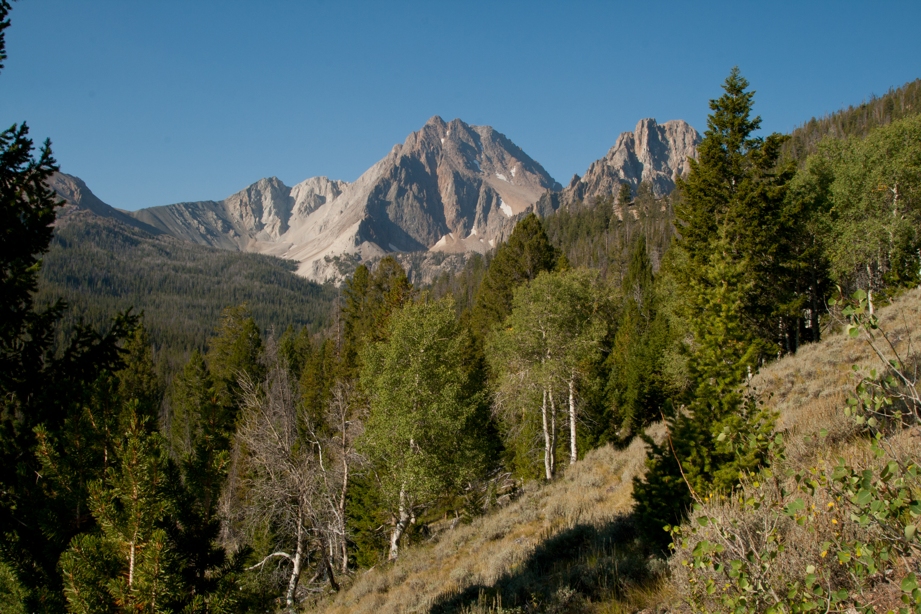
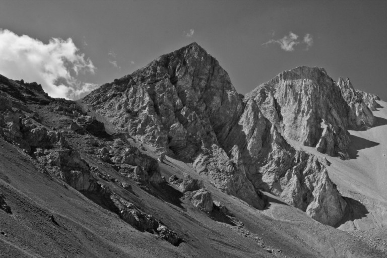
Now, in the distance we can see the impressive countenance of Castle Peak rising above the tree lined ridge and the leading edge of Serrate Ridge we had seen the day before. Looking left, along our ridge line traverse, we can see the Little Boulder Creek drainage below, green meadows spread out on either side of the creek, creating perfect hunting zones for the Red Tail hawks we see circling above. Again, a massive spectacle that cannot be captured accurately with cameras.
Looking back towards Castle Peak, we know somewhere at its base will be Castle Lake, a place we plan on visiting later today. For now, we descend switchbacks down to the valley floor, and to a trail junction that comes from across the stream at 2.19 miles, but we stay right on the Chamberlain Lakes trail, #47, which begins a climb up to our designated off trail route that will take us over to Castle Lake.
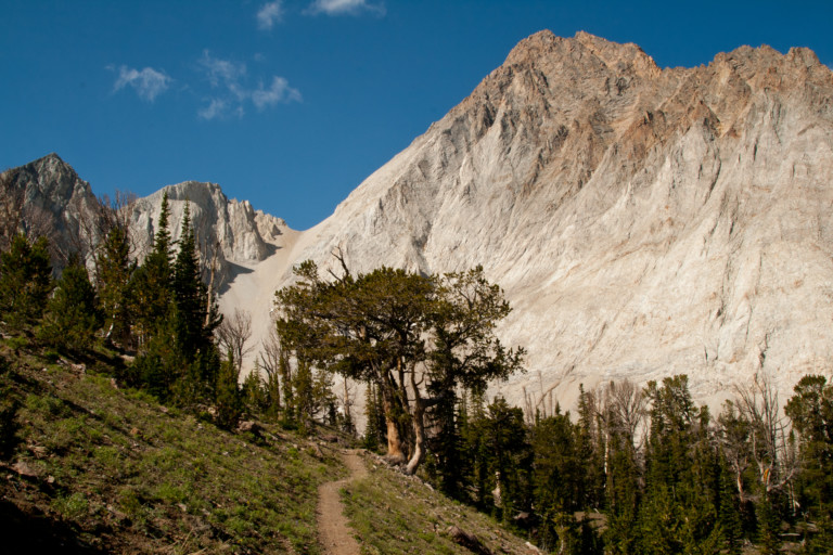
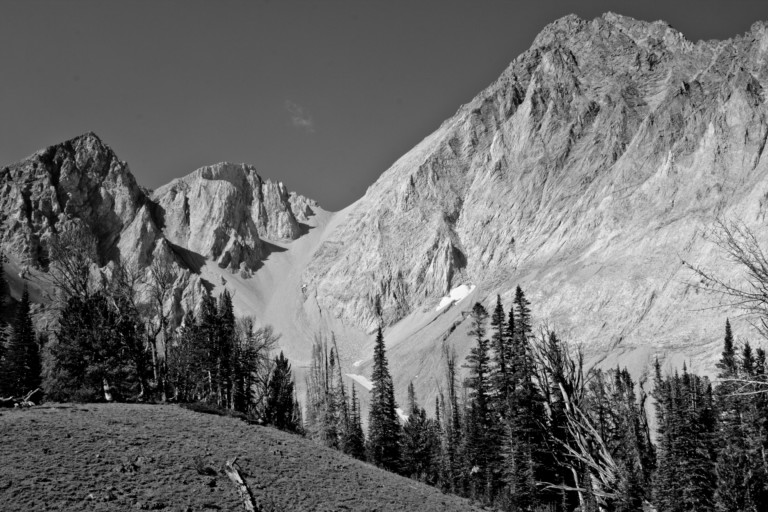
At 3.2 miles, we reach the Baker Lake/Castle Lake junction. This trail veers right to the lake, and supposedly, there is a trail from Baker Lake that leads to Castle Lake, but we decide instead on a later cut-off for Castle Lake.We’re still in the trees so it’s hard to see the peaks ahead until we reach a small meadow with clear views through the tops of the trees. What a view! The white of the granite peaks next to Castle Peak is striking, almost as if they’ve been carved from chalk, not granite. The view reminds me of one you would expect to see in a national park, like Yosemite, or Yellowstone.
Then, there’s Castle Peak with various smaller points protruding upwards from its sides, like minarets or towers on a fortress. No doubt contributing to the naming of said mountain. At 11,815ft, it is indeed a massive mountain. Still heading steadily uphill through trees that gradually give way to more mounded and open grassland meadows, we reach another trail junction at 5.24 miles, called the Wickiup trail, and we stay right here, continuing upward on the same Chamberlain Lake trail. Not long after passing this junction, the trail enters more rolling meadows sitting at the base of the next pass we have to cross over.
“…The mountains here are so massive they make the sky look small…”

The views here of the mountains require you to crane your head upward just to see the tops, and again, I cannot believe this place is not a national park. If these mountains were only a few hours away from the trailhead, as well as the large chain of lakes we saw yesterday, they would surely have to be protected for they would be overrun by gawking tourists; the spectacle really is that grand! The mountains here are so massive they make the sky look small…
Here, at the 5.85 mile mark we leave the trail, head downhill across the large, rolling grassy knolls, to a flat at the bottom of Castle Peak, it’s mostly dirt until it meets the flanks of the mountain, then it’s all white chunks of granite, creating a huge talus field that must be crossed to get around the edge of the peak to the lake, tucked into a cirque between Serrate Ridge and Castle Peak.
“…Safely around the peaks flank, and you walk into the cirque, the outlet of the lake here nourishes trees and grass before it plunges downhill…”
Cairns mark the entrance to a very well-worn trail across the steep talus field, and even though it’s well defined, traversing its flanks still creates a hair raising experience in a couple places. You definitely want to be sure of your footing here. Safely around the peaks flank, and you walk into the cirque, the outlet of the lake here nourishes trees and grass before it plunges downhill. Now, standing on the boulders and solid granite on the shores of Castle Lake, you can see the desolate, but rugged beauty of this place. A sheer rock face juts straight up to the top of Castle Peak on the one side, like a huge cathedral, while the leading edge of Serrate Ridge with its reddish granite completes the cirque on the other side. The towers of the ridge are visible in the distance. Rounded granite outcroppings encroach upon the lake, like cooled lava flows, some trees and grass grow defiantly here and there on the barren surface. It looks as if there might even be a place to camp there on the other side amidst the trees.
“…Unnervingly so, as if a giant were looking over your shoulder the entire time…”

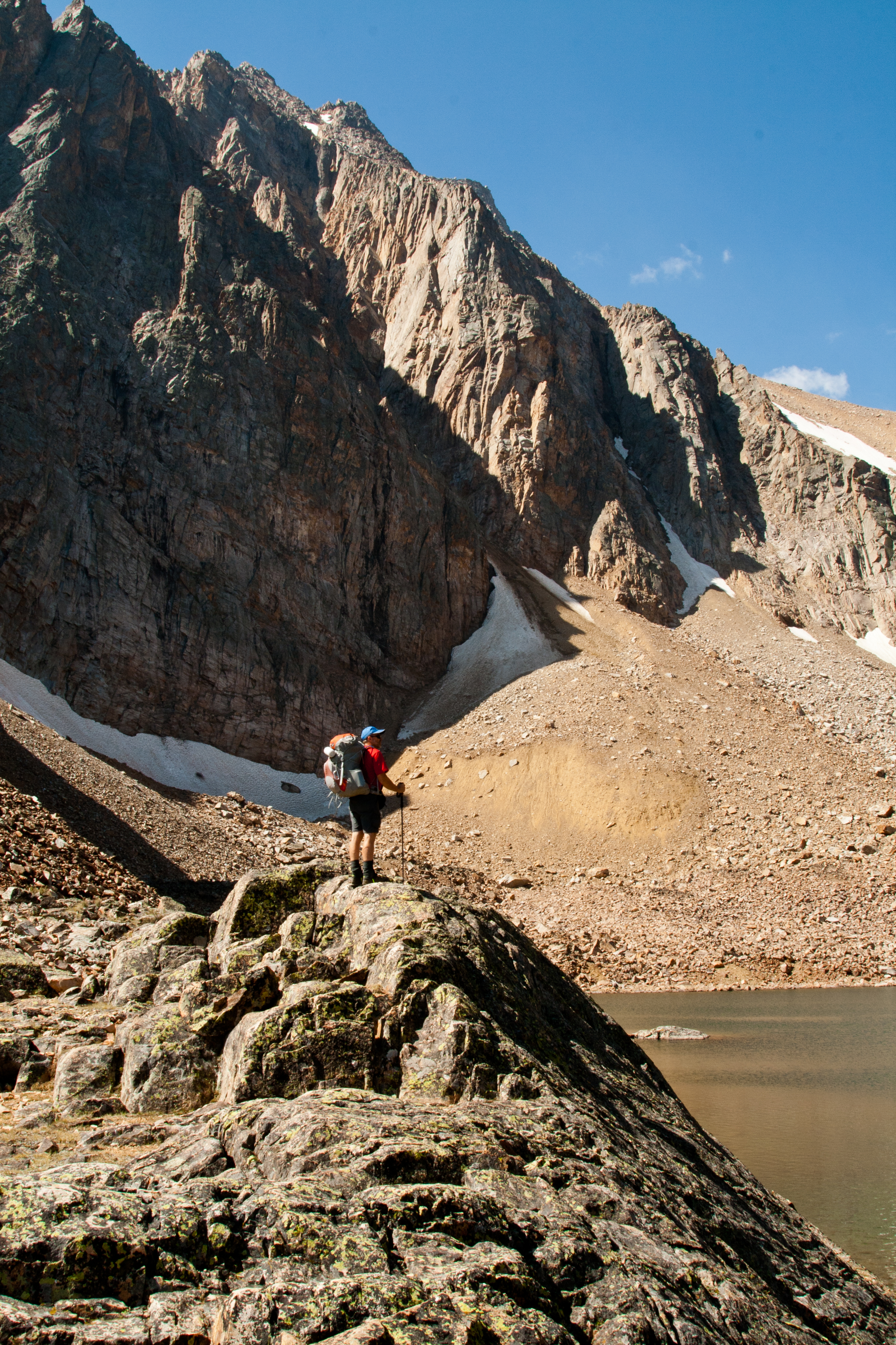
Another mind boggling place to feast our eyes on during this sunny day. Looking around, though, I can imagine how quickly this place could change from pleasant to menacing if a storm were to suddenly blow in. Lots of pictures later, we beat a retreat across the talus field and back to where we left the trail, to continue our upward climb over the pass. It’s all open, no trees to obscure the view, as the trail winds its way upward. I’m still in disbelief at how large the peaks are here for every time the trail leads away from them on its zig-zag course uphill when I turn to look back; there they are looming large and blocking out the sky. Unnervingly so, as if a giant were looking over your shoulder the entire time.
“…There, I did it…I used the word epic…”
Once at the pass, we have to hang onto our hats, as the wind is howling over the ridge. Great views again of the majestic peaks around us, stretching off into the distance. You begin to run out of words to describe just how epic this place is. There, I did it…I used the word epic..
Now, back off the pass in the opposite direction and again the terrain changes. From this side the peaks look completely different, a steady, unbroken hill all the way to the top, like a rounded loaf of bread, ripped in half, one side round, smooth, the other a ragged, sharp drop-off.
“…The ring of peaks keep their distance…”
This side of the pass isn’t nearly as dramatic, and the next 1.9 miles course along rocky hillsides and sparse tree cover to our next spectacle, the Chamberlain Lakes basin. We reach the Little Boulder Creek trail junction at 10.3 miles then keep to the main trail for another .4 miles to another junction at the outlet of the biggest of the Chamberlain Lakes, at 10.7 miles. The biggest lake of the Chamberlains, reached first here at the junction sets in a flat, with meadows on the trail side leading down to the edge of the lake. The backdrop is another 3 peaked ridge with trees growing up to the bottom of the barren slopes. The mountains here encircling the basin are slightly higher in elevation than the ones that surround the Boulder Chain Lakes, but not as dramatic or as peaked. On our right shoulder, to the NE is the west face of Castle Peak, still dominating the horizon, a hulking presence that always draws your attention. The ring of peaks keep their distance from the lakes until you reach the end of the basin, at the upper lakes.
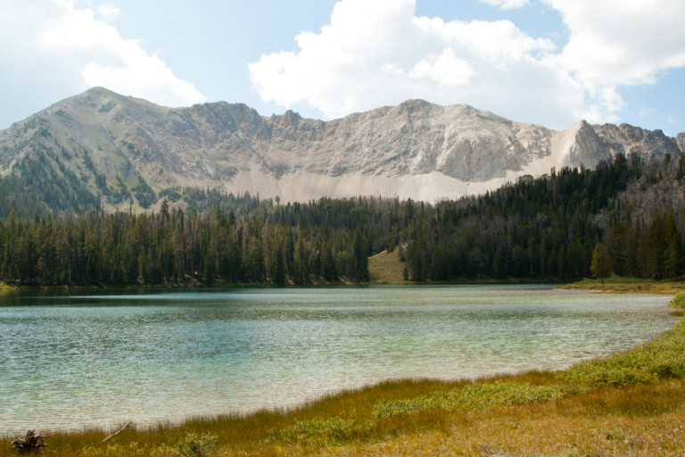
This is a large lake, with part of it obscured as it rounds a bend to the left. Tired and ready to get rid of packs that seem to gain weight with every half hour, we push on across the meadow, into the trees, and follow the path uphill to another small lake, and continue alongside the outlet stream from the lakes above. Finally we reach the first of the two upper lakes, at 11.6 miles. This one is also quite large, and we can see what look like good campsites on the right shoreline, under a small grouping of trees. And they’re occupied. Too bad, for they looked nice. We stop and talk and find out they had come into the basin by dropping over the ridge line to the west, from Washington Lake, and told us, decidedly, that it was a bad idea not worth repeating. We leave them to their fishing, and head up to the smaller uppermost lake to look for a campsite.
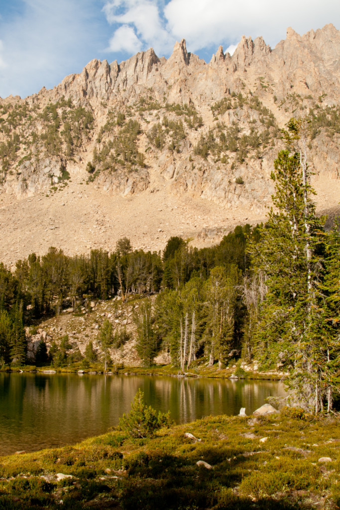
“…a large reddish ridge with snaggle toothed parapets lining its top…”
Here, on the west bank of the lake, towards the end, is a spot to call our own, and we choose it because it provides some relief from the constantly blowing wind. This lake, in my opinion, is more scenic than the lower, for on its east flank, rising up to the clouds, is a large reddish ridge with snaggle toothed parapets lining its top, a ridge that completes the encircling wall of peaks by joining up with the flanks of Castle Peak to the east.
The shore where we choose to make camp is flat and covered with meadow grass right to the water’s edge, so after setting up camp, it’s a quick dip into the lake to get cleaned off. We only stay in long enough to wash the grime off, and then it’s right back out, the water is that cold.Now clean, and dried off, we wander around the immediate area a while to take pictures and marvel at our surroundings, before making dinner.
After all the camp chores are done, we settle in for the night, and as soon as it starts to get dark, we see bright flashes light up the gathering clouds. Then a loud report echoes through the basin. More flashes, with each one followed by an even quicker peal of thunder, until fat drops start pelting us. Guess the weather report was right as we experience 20% chance of thunderstorms…Into the tent early, chased there by the rain and lightning…