Ranking: 4/5 Hey, it’s the Wonderland, OK??? And, IMHO, this is the best section, as it covers some incredible ground above tree line, with constant long range views of the surrounding mountains and peaks. On this part of the trail,, you’ll also get to see a large variety of the available wildlife, and see some of the old history of the park in it’s iconic shelters built long ago. This section of trail has it all!!!
Difficulty: 6/10 There are some sections that will take it out of you, for sure, but for the most part, this is a moderate hike at best, and enjoyable for it’s short distances between camps. The only reason that it makes a 6 on this scale, is because the snow made it more of a challenge for routefinding than normal, as the trails and signage here are some of the best around. There’s even a completely enclosed outhouse at Summerland, complete with hand sanitizer, for crying out loud!
Maps: We used the Trails Illustrated Map of Mt. Rainier, by National Geographic. There are a multitude of resources for this trail, but we like this map because it’s waterproof, and tear resistant. Also, the trails are clearly marked, making for easy navigation through this section of the park.
Permits: You will need to make reservations for overnight camping on the Wonderland, and they fill up fast, so early planning is a must. They will start accepting applications on 15th of March, and will start processing them on April 1st. I can remember staying by a fax machine at 12:01am on March 15th, and sending in my request to do the entire trail…See this link for more info,http://www.nps.gov/mora/planyourvisit/wilderness-camping-and-hiking.htm
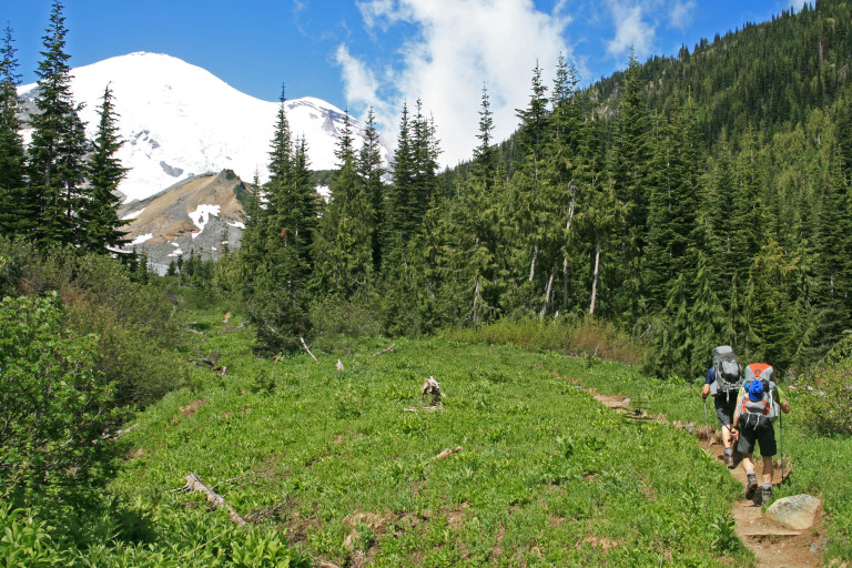
Another great weekend for weather! Forecasts call for sunny and warm, and that’s perfect for our 3 day on the Wonderland trail. This trek will be a through hike, as we’ve parked cars at either end of the route, and it will cover approximately 15.5 miles. Roughly. I say that, because that’s not counting the endless wandering that we did, and the fact that most of the trip was spent slogging through snow, which seems to take more effort and time.
Day 1.
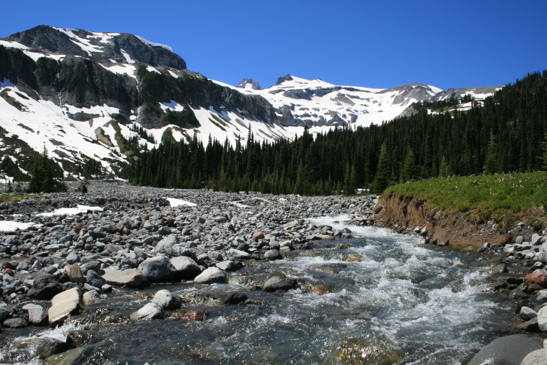
4.3 miles, 2186ft elevation gain. Brian Sunderland will join us on this trip, so the 3 of us start at the trailhead at Fryingpan Creek, after driving around to the other side to drop off our return ride. A good start, as the trail is a gradual uphill through old growth forest along Fryingpan Creek, with an occasional waterfall to entertain us, and a quick glimpse here and there of the rugged terrain ahead.
…the white glacier cap radiates brilliance like a beacon from a lighthouse on a dark night…
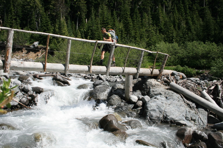
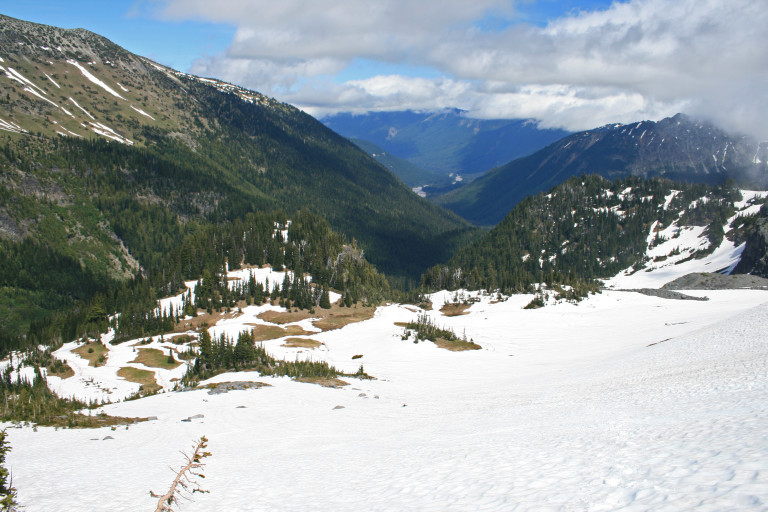
Once at the Fryingpan creek footbridge, the going gets steeper, but the pain of that is lessened by the sky filling outline of Mt. Rainier ahead of us. In the cloudless sky, the white glacier cap radiates brilliance like a beacon from a lighthouse on a dark night. You can’t stare at it for long without it hurting your eyes, even though you find your eyes wandering back towards it, such is it’s magnetic appeal…Here the meadows start to fill with snow, and by the time we start the final switchbacks up to Summerland, we are now crossing larger and larger snowfields.
Once on top, the normally flower filled meadows of Summerland now look like Winterland, as the fields lay under large banks and drifts of snow, only occasionally peeking out from under the white blanket here and there. Even with the snow, the place is still gorgeous, with awe inspiring views of the Mountain. We continue to the camp, to see if we can find a spot where there is no snow and are relieved to find the best spot completely bare and dry!
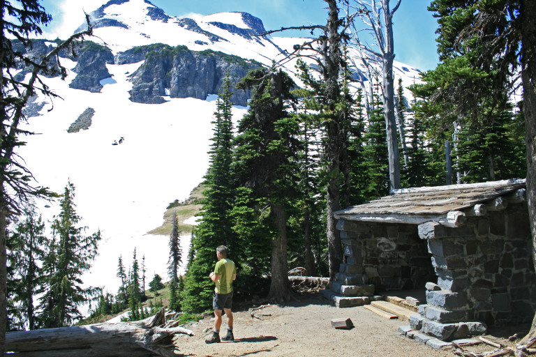
We set up camp, and then start wandering about, making a quick trip over to the shelter, and are amazed to find that we are the only ones here. I look at my watch and am stunned to see that it is still before noon! No wonder no one else is here…Now, what are we going to do for the next 5 or 6 hours???
I’m all for lazing around in camp, but, that amount of time on our hands, we might as well do something. As we’re looking around, it’s amazing to see the amount of snow still here. The slopes of Meany Crest that hold back the leading edges of the Fryingpan Glacier, are still draped in deep snow. In fact, the snow fields ascend from Summerland, to the base of the crest, and all along the steep slopes towards Mt. Rainier and Little Tahoma.
…After all, you can see where a skier has left long graceful swoops on the untrammeled snow…
From Summerland, looking west towards the mountain, there are several ridges that lie between us and the edges of the Emmons Glacier, the most massive of all the glaciers on Mt. Rainier, so we decide to take a little jaunt across the snow fields and small ridges to see what we can see…After all, you can see where a skier has left long graceful swoops on the untrammeled snow, after he gained a high point just shy of the leading edges of Fryingpan Glacier, so it beckons us to investigate further…packing lightly, we head uphill across the snow covered expanse, gaining one ridgeline, then another, each one allowing us greater views, till finally it seems that if we can get to that last one, we might finally be able to have a clearer, more unobstructed view of the mountain.
From the ridge that we currently occupy, to the next, though, looks a bit more daunting, as the slope here is steeper than the last few. It forms a wide bowl, and the small streams of melting snow and ice have left depressions in the snow that look best to be avoided…Therefore, the best route will be to stay closer to the top of the bowl, but below where many rocks and chunks of snow and ice have skidded to a stop after falling from the crest above.
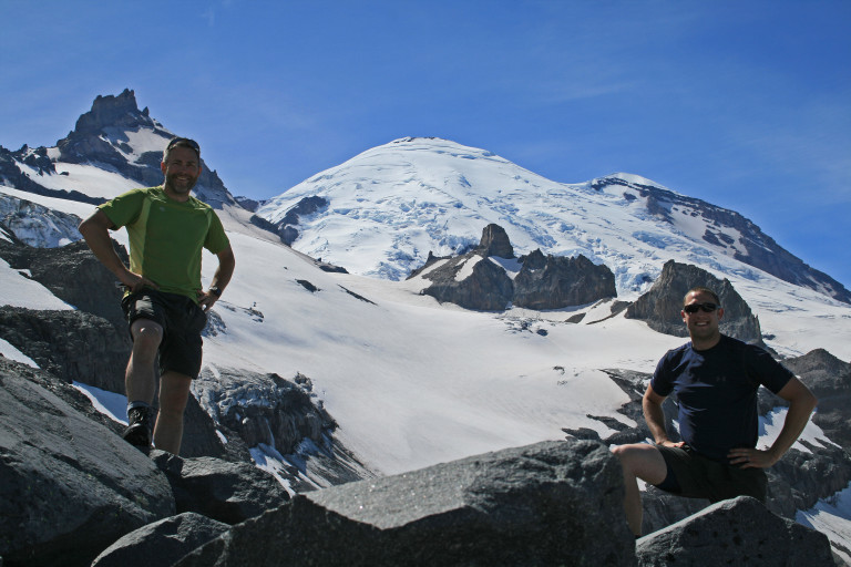
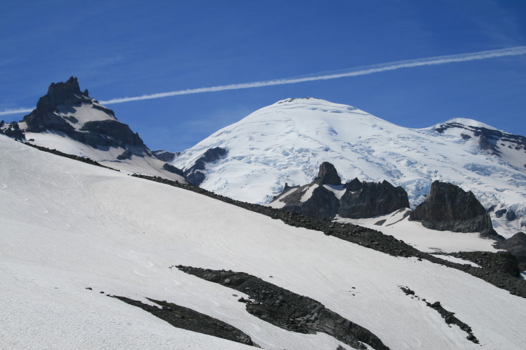
At points, it seems that the incline must be 40 degrees or more, and we have to take care kick-stepping across the surface. Almost to the desired ridge, I get the chance to practice self arrest. One foothold gives way, and the next moment, I’m on my butt, sliding rapidly downhill. A quick flip over on my belly, and moments later, I come to a halt. Even though I’m pretty sure I wouldn’t have been hurt, as it was a loooong run-out here, it still puckered me up pretty good. Nothing like a quick burst of adrenaline to energize me for the last 100 yards, or so. Phew! But, what a view! We have gone from appx. 5990 feet at Summerland to just a little over 7000ft here below Fryingpan Glacier, and have a completely unobstructed view of Mt. Rainier! Little Tahoma now seems as if we could get there in an hour or less, and we can see every detail on the icy slopes before us.
Across the now wide open divide, we can see the edges of the Emmons Glacier, and in the distance, the trails cut into the sides of Burroughs Mt. leading back to Sunrise. K spire is now dominant, and sticks up like a hitch hiker’s thumb, and several small waterfalls flow out of Fryingpan glacier. Impressive! We linger for awhile, and take lots of pictures, before continuing on. Even though it took me about 10 minutes before I was finally able to hold the camera steady again. Below us, at the end of this ridgeline, is a prominent rock that juts out above the beginnings of Fryingpan creek and overlooks the valley below, like a castle turret.

We glissade in the snow below us, saving us some time walking, and providing some much needed cooling, as well! The views from here are also worth the effort to get here, and it’s also from this vantage point, that you can see up towards Panhandle gap. Well, at least you would have been able to, if not for the growing fog bank curdling down out of the gap, becoming thicker, and increasingly menacing as its tendrils reach further towards camp at Summerland. Time to go, we pick a slightly different route down towards camp, and all goes uneventfully.
…spent over an hour just this side of Panhandle Gap, for it was whiteout conditions up there, making it difficult to navigate…
After filling water jugs, we return to camp, and there are now more people. 3 other groups have shown up, and we had a chance to watch one of the groups appear out of the fog that covered the route up to Panhandle gap. They used the shelter here, so we stopped by to ask what it was like over at Indian Bar. Lots of snow, they reported, just as we had feared, but they also told us that they had spent over an hour just this side of Panhandle Gap, for it was whiteout conditions up there, making it difficult to navigate.
Luckily for them, the fog had not reached Summerland yet, so once they were below the fog line, they could see where they were. Doesn’t sound like fun. They had no GPS, only map and compass, but, without being able to see, that makes it very difficult to navigate. Hope we don’t face the same problem tomorrow! Back at camp, we set to making dinner, and just as in the last hike, we try a different recipe!
This time, I attempt a meal that required bringing in several different veggies to chop up and stir in the hot rice dish, a recipe that I copied off the back of the box of 10 minute rice from “Success”. They package their rice in little plastic bags that fit perfectly into a Jetboil, and two bags make plenty for 3 or 4 people. The meal was called Greek Chicken and Rice Salad, and it was a welcome relief from the standard trail fare. Each time we try a different recipe that is successful; we’ll post it here in the trail report!! After the satisfying meal and cleanup was over, it was around 7:30pm, and the fog that had been menacing us, now completely engulfed us, we could see no further than the edges of camp.
Occasionally, the wind would part it long enough for us to see the moon that was now almost full, and the fog seemed to ebb and flow in irregular patterns. Sometimes, we thought it would lift, and then it would fill back in. Perhaps tomorrow, this would burn off? A question only time would answer now, and we turn in.