Ranking: 3.5/5 Not quite a 4, but close. The views along the trail are good, especially in the sections where you’re on open ridge line looking out over the valley. Lots of lakes and the PCT section is in good shape. Thunder Lake is very scenic, but there aren’t a lot of good places to tent, maybe 4 if you don’t expect rain? There are quite a few more if not, where small pools of water dry up and leave round dirt impressions.
Difficulty:7/10 For some could be an 8. Difficult in sections, especially if wet. Lots of step ups over roots and rocks, more so at the beginning and end of this trail. Route finding required, but not overly difficult in the boulder sections. There are Cairns to follow and the way up to the lake is fairly obvious. Only a few good places to camp on durable surfaces or that are established. Not really a great choice for people just beginning in backpacking, unless going with more experienced backpackers. Mileage isn’t too bad, but with 3800ft of gain, definitely in the “more difficult” category.
Getting there:
Take I-405N past Kirkland, then take exit 23 to merge onto WA-522E, then go about 14 miles. Exit onto US2-E, go 47 miles and turn right onto NF6095 and follow gravel road about 1.2 miles, when you’ll see a road turn left uphill. Turn left here, and trailhead is about 100 yards up.
Maps: Green Trails #176 Stevens Pass, Trail head: Tunnel Creek #1061
Permits: Northwest Forest Pass required to park at trailhead, self-register at trailhead register.
Thunder Mountain Added 9-14-2019
Looks like rain is in the forecast, but it seems a rare occurrence anymore here in the great green but wet PNW when rain isn’t in the picture…This weekend will be no different, with a 100% “chance” of rain from the weather prognosticators. Which made me wonder, if it’s a 100% chance of rain, shouldn’t 100% be a certainty? If it’s still a “chance”, wouldn’t it be a better served guess if it’s only 99%??? Then, for certain, there’s still a chance that it might not rain…Just sayin’…
Anyway, we’re sure to pack rain gear for this, as Sunday for 100% certainty, looks like we’re gonna get wet.
This will be the first time that I’ve done a hike with Tyler and Gee, nephew and uncle, which makes for a great opportunity to spend some quality time together.For Tyler, this will be his first overnighter, so I’m hoping it’ll wet his appetite for more…
After loading everyone into the truck we head out to the trailhead for Tunnel Creek, early in the morning the traffic isn’t bad, so we reach the small parking lot around 8:30am. So far, no rain, but the skies are overcast, just hoping now that we’ll reach Thunder Lake before the rain sets in.
Loading heavy packs that feel as if we’re gearing up for a 3 day instead of an overnight, we’re on the trail by 8:50am.
Day 1 3736ft gain/543ft loss, 7 miles, 25,790 Steps.
As I noted before, there aren’t that many places to park near the trailhead, depending on how well everyone parked, maybe enough for 12 cars??? There were about 10 already there, so we were lucky to find a spot. After self-registering, we’re on our way, and the trail wastes no time in gaining elevation. At first there are a few short flats where there are bridges installed over marshy or muddy areas, but within a half mile, the trail climbs steadily among moss covered old growth, and the trail through here is packed with roots and rocks that create steps or obstacles as you trudge upwards. Knowing it’s gonna rain tomorrow, some of the steeper sections that are dirt look like they’re going to be one slick mess on the way back down.
“…We also see several other tasty edibles as well, like Hedgehogs, Comb Tooth, and Oyster to name a few…”
Mushrooms are in abundance, and some of the King Boletus here are huge, their caps bigger than large dinner plates, like fat Frisbees on trunks. They’re everywhere, can’t remember seeing so many clustered together like this. We also see several other tasty edibles as well, like Hedgehogs, Comb Tooth, and Oyster to name a few. We pass several people that are headed down, many are day hikers, but a few are people that have spent the night at different lakes along the way.
Less than half a mile from the first lake, Hope, I’m just kinda lost in that trail daze of putting one foot in front of the other, when, “Wham!” My leg gets that sharp burning pain, like being jabbed with a white hot poker smothered in tabasco sauce. Having felt this particular pain before, I know exactly what is going on as I get snapped back harshly to reality. “Ow! You rotten little (then a torrent of regrettable obscenities)”, then, “Run! Hornets!!” As I swipe at them frantically.
“…They reminded me of a couple runners heading into a 60mph wind…”
They don’t stop until you swat them off, I can see the one clinging to the side of my left knee, and I get him off, then feel another stinging my right ankle hard. It’s a miracle I don’t fall on my face, as I’m trying to swat both places at once, while bending over and running at the same time. It’s a delicate dance while you have a pack on your back, imagine Quasimodo trying out a new break dance move, all the time flailing and wailing…Yep, pretty sure it was humorous to bystanders. Except, there were no bystanders, more like fast walkers trying to get the heck out of the way. I could see Tyler and Gee making their best effort to run uphill with packs on. They reminded me of a couple runners heading into a 60mph wind, like they’re going in slo-mo, or trying to run through Jell-O…It might have been funny except for the fact I too, was just doing my damnest to get my rear out of there…
Thankfully, we don’t have to go far to get away from the little demons, and I stop to assess the damage. They got me twice around the left knee, and impossibly, below the top of my right boot top, through the double layer of socks! Back in the comfort of my easy chair, I try to figure out what exactly these little terrorists are, but can find no picture. They’re about the size of a housefly but with the attitude and punch of something much larger like a mini stealth fighter, these little guys pack a punch! My leg and ankle hurt and burn for the rest of the hike, with the one on my ankle getting much worse by the end of the hike…
“…Only thing missing was of course Queen Cleo and the scoutmasters using big palms for fanning …”
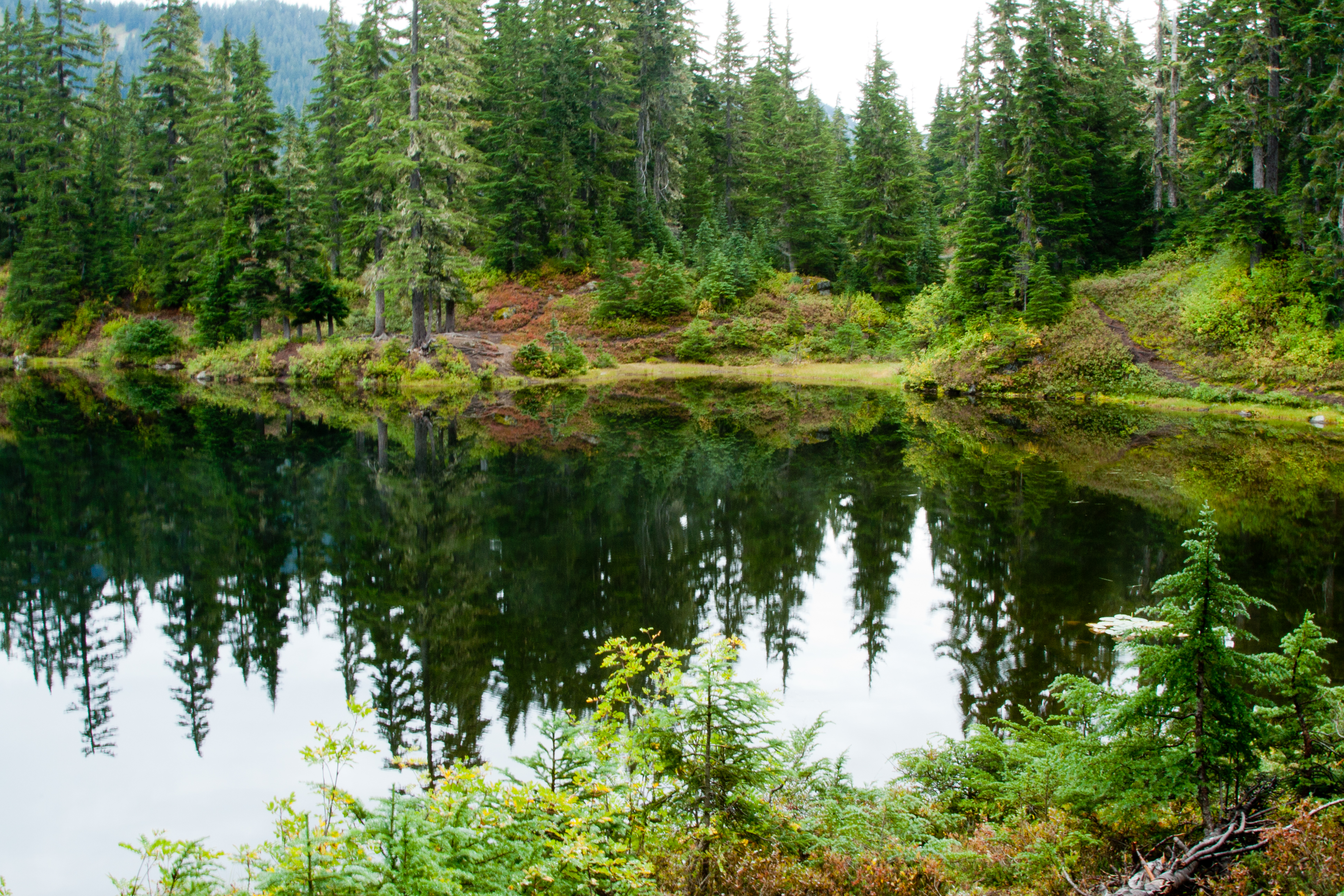
We reach Hope Lake at 1.5 miles, and it’s a pretty sub-alpine lake at the 4400ft mark. With no wind, the surface is mirror- like and reflects back the surrounding alpine firs and the beginnings of fall colors, as the grasses are yellowing and the huckleberry brush is starting to turn crimson. We stopped to admire the view, take some pics and talk to a couple rangers that were here doing trail work, and they asked if we had seen some boy scouts on our way up, and we said no. They were bringing in a new back country toilet. Within minutes they showed up, four of them carrying it over their shoulders and it looked like a scene out of Cleopatra. Only thing missing was of course Queen Cleo and the scoutmasters using big palms for fanning to complete the picture. Looked like the best seat on the trail! Thanks guys, for lugging that into the backcountry!
Saying our goodbyes, we head out again and now we’re on the PCT for the next 3.7 miles. Now that we’re on the PCT, the trail is in much better shape, and maintained better than the trail in, although I can say it would take monumental effort to improve the trail in. It’s steep along Tunnel Creek and pretty much has to go straight up along the creek drainage, which doesn’t leave any room for switchbacks, let alone getting steps in amongst the well-established roots and rocks.
You go through some small meadows just past the lake, then up some switchbacks until you reach the 5200ft mark, and the constant up mellows out a bit, as you’ll go through more open meadows. At the 2.7 mile mark, you’ll have wide open views down and across the Trapper Creek drainage as the trail side hills the side of the valley. It continues this way all the way to your turn off above Trap Lake. You’ll pass the cut-off for Trap Lake at the 4.7 mile mark. Then, staying right, the trail continues up along the ridge above the lake through a large talus and boulder field.
“…pointing skyward like horns on a multi- pronged crown…”
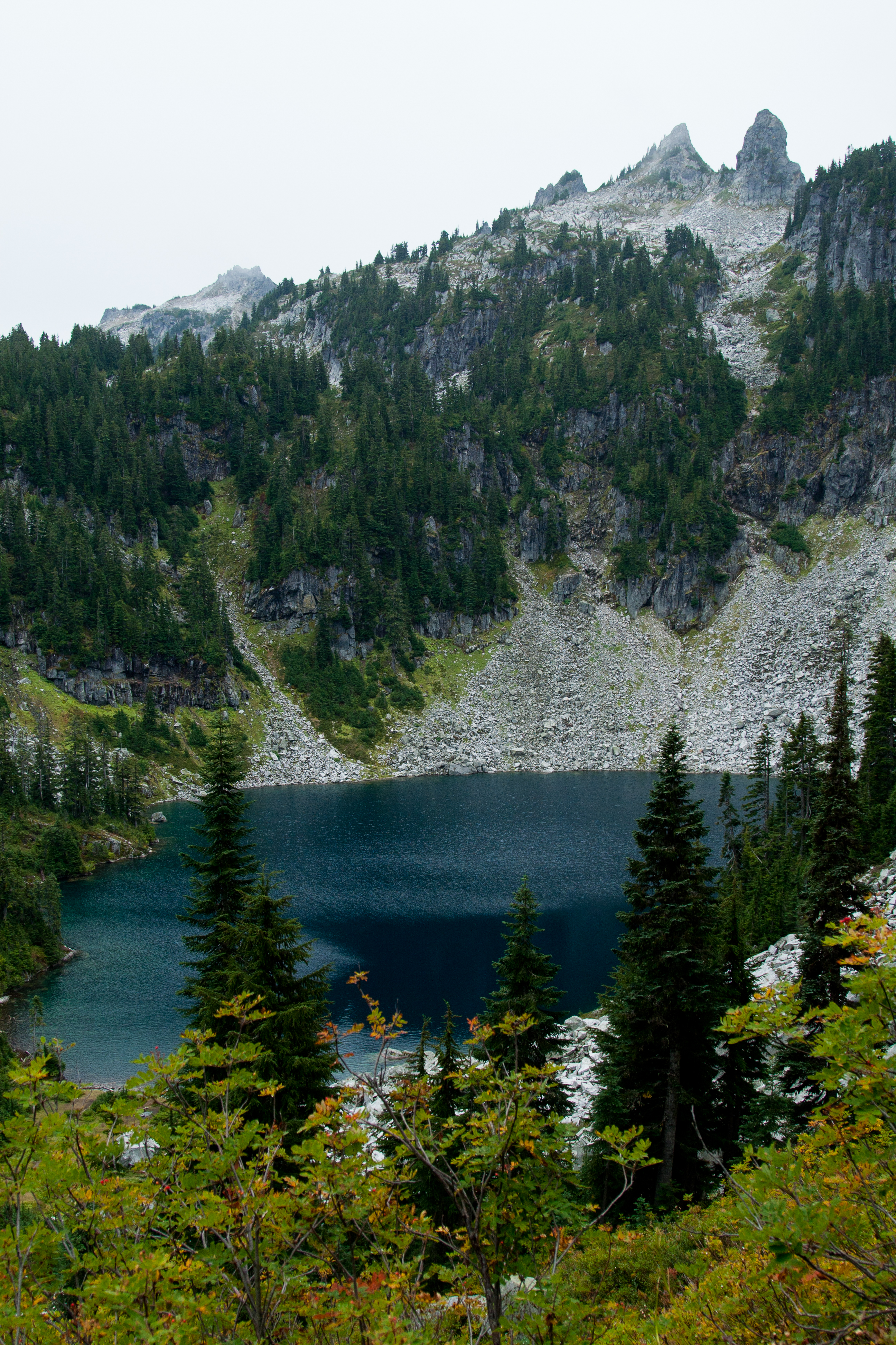
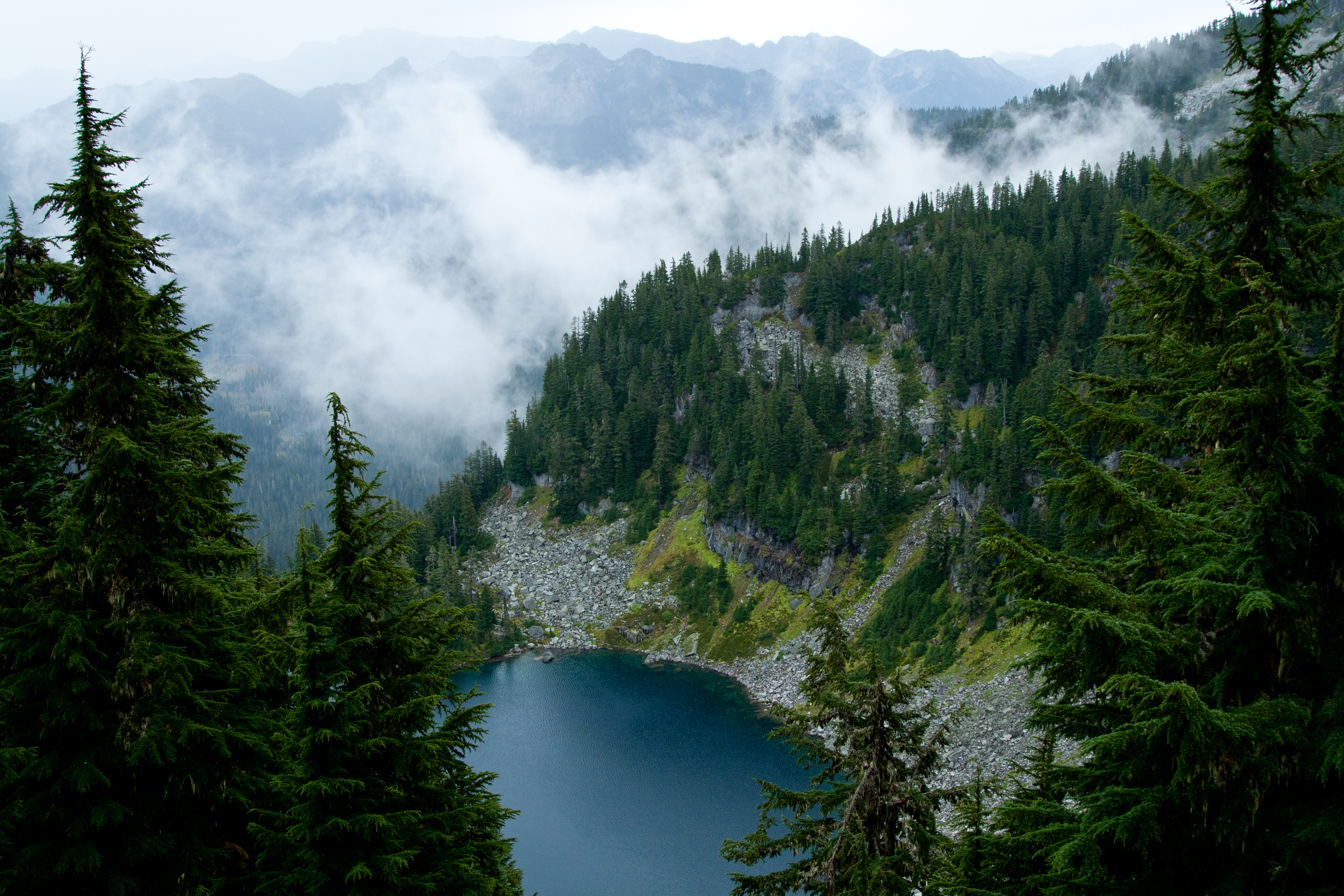
The views here are worthy, to say the least. You look down upon the deep blue waters of circular Trap Lake, ringed on this side of the bowl by the white cascading granite boulders that are stacked and tumbled right down to water’s edge, and on the opposite side by the outlet stream, are grassy open areas that look ideal for setting up camp. From this vantage point on the trail, you can look south and there is a rocky ridge line with several spires, pointing skyward like horns on a multi- pronged crown. This is the ridge that you’ll be negotiating to get to Thunder Lake.
We stop for a quick refuel break as it is such a great view, and it starts showering a bit…Sure hope this doesn’t continue…Now, from this side of the lake, the trail continues side-hilling the ridge around the lake to some steep switchbacks that take you to the top of the ridge at 5600ft elevation. At this nice flat spot on top of the ridge you’re 5.21 miles in, so you’ve already climbed 2750ft of ups. More to come!
Just to the left of this flat spot you can see a climber’s path that cuts down below a large rock face. Follow this and it climbs steadily up through the trees that grow along the ridge. I say climbers trail as it obviously isn’t maintained, so it’s more like a game trail. Still, it’s easy enough to follow…
“…keen attention will need to be paid here…”
We pass about 3 or 4 small sections that are narrow, steep, and mostly dirt, that are stair-stepped like kick steps in the side of a snow field. Remember, you’re on a ridgeline here and as the narrow steep trail cuts upwards, these 3 or 4 places are slightly exposed. If you slip, and tumble off trail, there are only a few wispy, small alpine firs to block you from taking a plunge off the ridgeline, so keen attention will need to be paid here…It’s one thing to do it when it’s dry, and we’re all thinking this is gonna be a bit more challenging when the rain comes, making this a muddy, slick mess…Finally, we leave the ridge and enter our first boulder field, about .3 miles from the turn off from the PCT. You are now about 5.4 miles in.
“…an ancient garden long lost…”
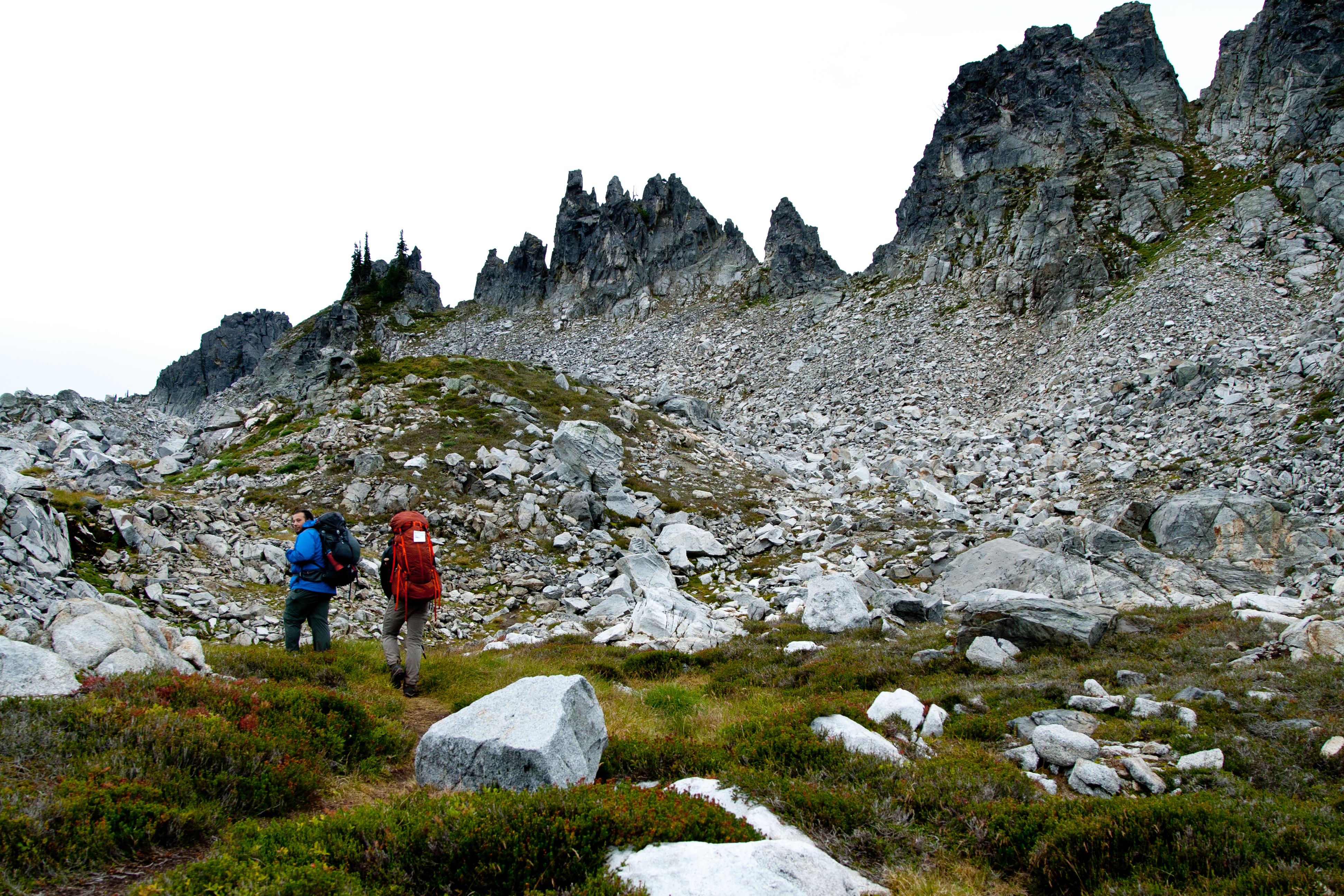
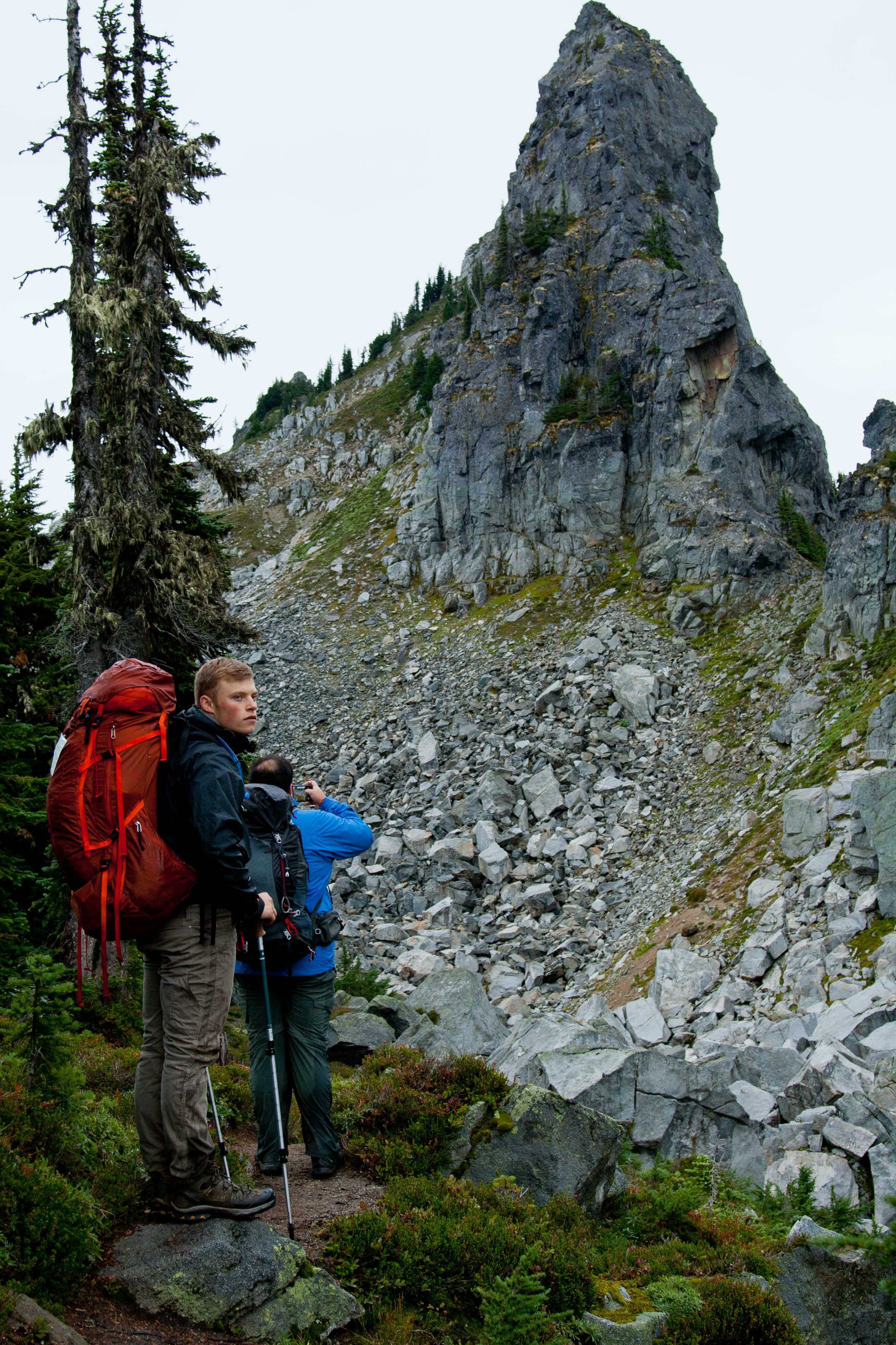
From now on, you’re out in the open, on the ridge with the large spires that you could see from Trap Lake, large scattered boulders lay tossed around here at the base of the spires, and shattered granite makes up talus field run outs below them. Veins of green vegetation grow between the patchwork slabs of flat granite and rounded outcroppings of the same, worn smooth over the centuries. The veins of green connect with small patches of meadows, and it creates a sort of austere rock garden, intriguing in its own right, as if it were an ancient garden long lost. With gray skies threatening to storm as a backdrop, it creates an ominous but unmistakable beauty.
There are cairns to follow through the boulder fields and they do a pretty good job of leading you the best way through the jumble of stone. Once through the small sections of boulders, you hit patches of meadow that have a defined path that leads ever upwards. As you cross this rocky ridge, you’ll pass by the base of granite peaks that have all shed rock, creating some of the large talus and boulder fields that you have to negotiate.
“… as if a meteor strike hit the center of the basin here…”
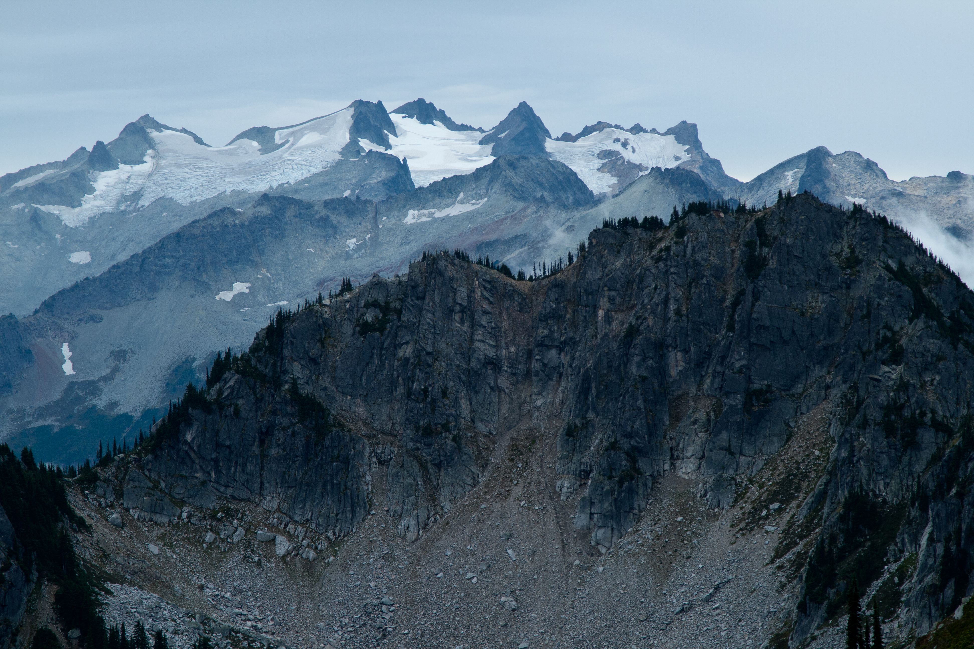
Finally, you’ll crest out on the last ridge line, and you get your first views down onto Thunder Lakes. The upper lake is the most dramatic and first one to come into view. Small grassy areas around rounded and smooth benches of white granite that seem to slope slightly skyward, as if a meteor strike hit the center of the basin here, leaving a rounded depression for the lake and shattering the surrounding mountain tops while melting the rock around the impact and blowing it out and upwards, like a frozen wave. The water is a clear sparkling blue, a nice contrast against the serrated granite skyline. Also from this high vantage point, you can see all of the surrounding peaks in the distance. Across the valley, directly south is the multi-pronged crown of Mount Daniel and draped between the jagged points of this crown is the Lynch Glacier. A scene worthy of the amount of energy expended to get here…
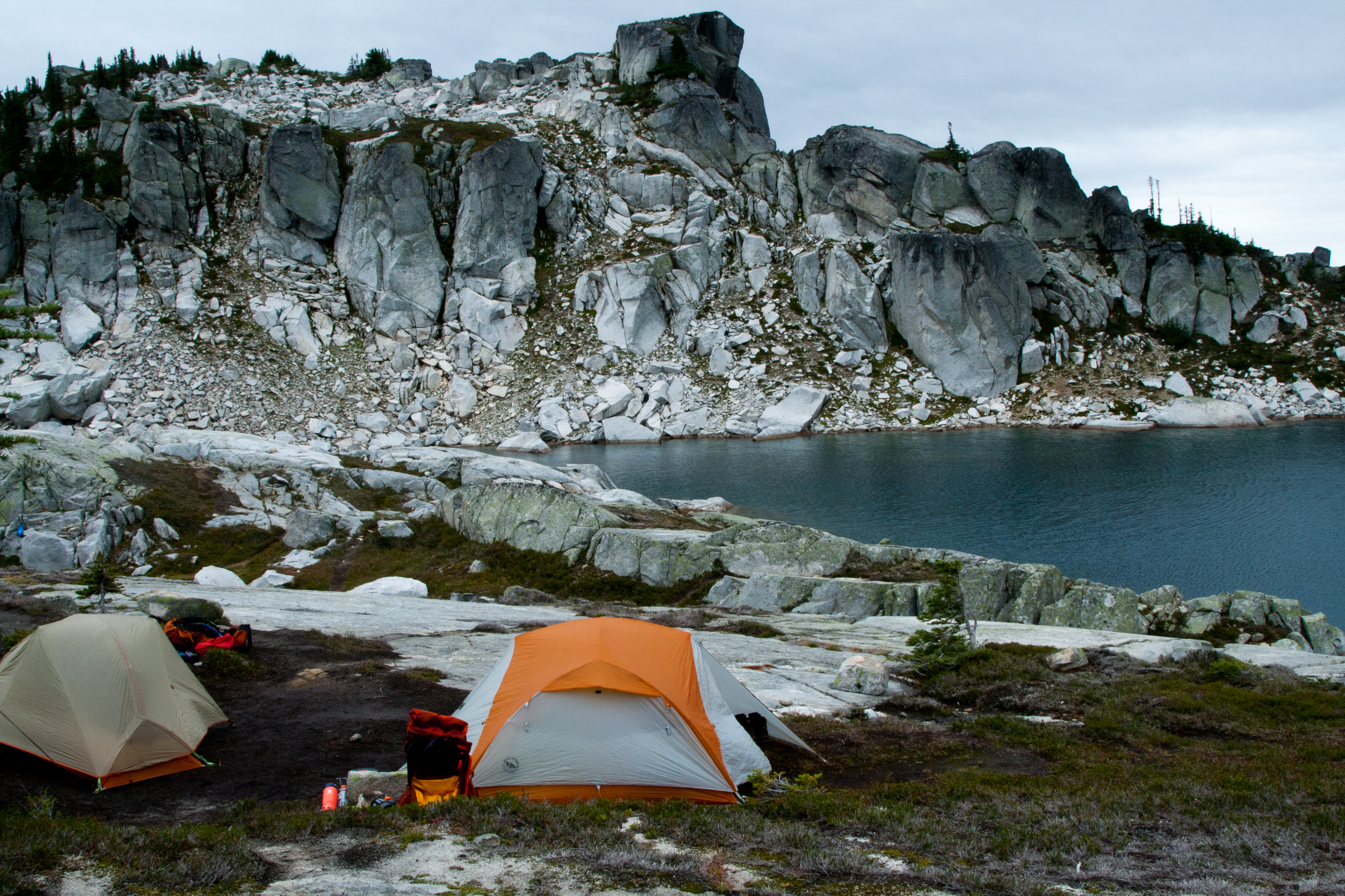
We reach the shores of the lake right at 3:00pm, and are quick to find a place to set up camp, before the inevitable rain hits. I had borrowed a siltarp so we would have shelter from the weather, a place to set up a kitchen and be able to avoid the weather without hiding out in the tents.
“…as if its’ belt were pulled too tight…”
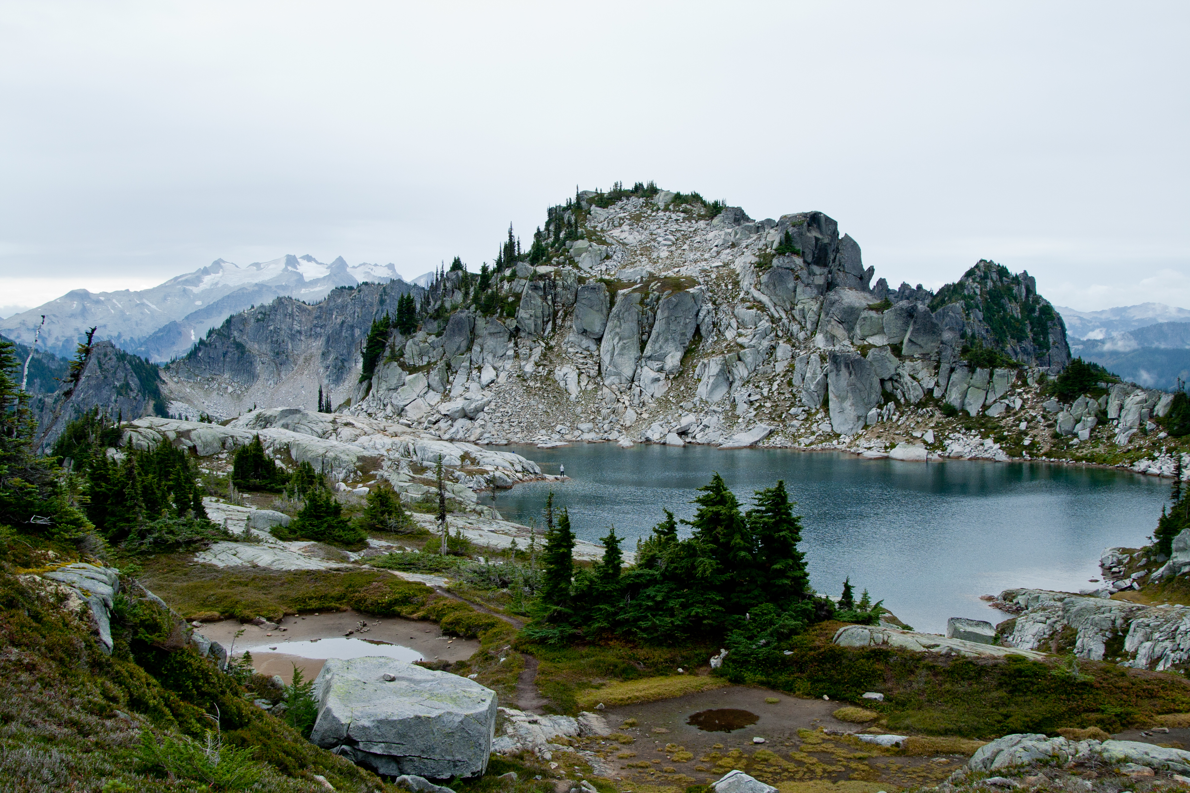
With camp set up, we could relax some, and spent some time surveying the area. There were these big flat benches of granite with huge wide seams of quartz running through them, like chalk lines on a football field, tilted slightly upwards from the lake, and these benches ended as edges of the cliffs, forming the end of the upper lake basin. From these edges, you could look down upon the lower lake, then down across Square Lake. Which, by the way, doesn’t look square at all, more rectangular with the middle squeezed together, as if its’ belt were pulled too tight…Directly north on the last ridge that we came up and over, there is a large peak that has as huge boulder the size of a look-out balanced impossibly it seems on the rounded shoulder of the peak! It looks like a strong breeze would send it tumbling.
Thunder Mountain itself from the lake is mostly a rounded knob but its most impressive feature is the ridge of rock in front of it that walls in that edge of the lake. It looks like huge block remnants of a fortress wall blasted apart long ago, blackened on the edges before surrendering to white. Stark, but very photogenic, as I find it difficult to quit taking pictures of it, wanting to make sure I capture at least one good photo…
There was a couple of guys fly fishing when we arrived, but I don’t think they had much luck, as I never saw any fish jumping. Maybe one of the good reasons for that was because there are little to no bugs!!! Best part about hiking in September.
Dinner is Chicken and Mushroom Pasta, with mashed taters and Cheeto’s! Always sounds odd until you try it…First time for both Gee and Tyler, and both gave thumbs up!! So far, the rain and wind have stayed at bay and we’re grateful for that, makes the whole dinner and cleanup chore afterwards a lot easier…Everyone is tired and now full, so we don’t stay up too long after it got dark. I stay up until 10, but only because if I go to bed too early, I’m up around 3:00am. Just can’t lay in bed for that long, get stiff and sore. All of us oldies can appreciate that…
“…Hard to sleep through all that noise…”
Well, that rain they were forecasting for 11pm? Pretty much nailed that, as it started around 10:45. Lightly, at first, then it got with the program. Most of the night, the wind gusted about 20 to 30mph (appx) driving rain in front of it. Hard to sleep through all that noise and I’m not talking about Gee snoring…