Once there, follow the trail 6 miles to Camp Lake, at 1.4 miles in, you will come to a trail junction, and one sign says “to PCT” one way, and the continuing trail says “To Green Lakes”. Stay on that trail. You will cross a couple streams, Soap Creek, which has a foot bridge across, and will have to ford the North Fork of Squaw creek. Just beyond the crossing, you will see the turn off to Demaris Lake, but continue southwest on the same trail to Camp Lake. Should see some signs pointing the way. From Camp lake, it’s all off trail from here, over the saddle between the South and Middle Sisters, by Chambers lakes, and about another 2 miles beyond the last of the lakes to the junction with the PCT trail. Head Right on the PCT until you reach trail #3511, turn left headed west, for a little over a mile to a multiple trail junction. From here, nead north on trail #3547 which will shortly bring you to another “Y” junction. We headed left on trail #4348 towards Husband Lake, and eventually to Eileen Lake. Continue on the same trail back towards Linton Meadows, till you join up again with trail #3547. This will take you left to join back up with the PCT in about another mile and a half. Turn left on PCT, and stay on PCT all the way to Scott Pass, by South Matthieu Lake. Turn right and go down Scott Pass trail, #4068, appx. 2.2 miles to junction that turns right, and will lead you back to Pole Creek trailhead. Just before you reach this trail junction, you will see a slightly used “trail” leading off to the right also, that leads to Yapoah lake. Your junction should be just a little further ahead, to the right. Follow it to the junction that you saw the first day, and turn left, and follow the trail to the Pole creek trailhead.
Maps: We got our original idea for taking this hike from “100 classic hikes in Oregon”, published by The Mountaineers Books, and I suggest strongly that you also pick up this book, as it has some very useful trail information. Also, the map we used was by Topo.com, I purchased it on-line. It was a little expensive, but very worthwhile. That way, you only have to really print the grids that you want, or need. I thought the map was extremely useful. We also, because of the amount of snow on the ground, used a Garmin GPS unit, with our trail data loaded in, so that the entire trip, we never got off trail…Much…Actually, I think we shortened the trail by a few miles, as we crossed snow fields, and cut off mileage. Of course, when the trail is completely visible, you should use the trail, so as not to trample everything under foot.
Permits: In order to complete this loop hike, it will require a special permit, as you will be passing through the Obsidian Limited Entry area., and you will need to plan ahead, as they will accept applications up to 30 days in advance of your hike. The only exception to this rule, is if you are doing the PCT trail thru-hike. You will also need a Northwest Forest Pass to park at the trailhead, and you will also need to fill out a backcountry permit at the trailhead. For more info, call the McKenzie River Ranger District at (541)822-3381. Or, for more info, check out the website for Deschutes and Ochoco National forests, and look for the 3 Sisters Wilderness Area.

This time, we decide to expand our horizons beyond what the mountains of Washington hold, and plan a trip into Central Oregon, on a loop hike around the 3 Sisters, outside the town of Sisters, Oregon…OK, actually, it might be better described as a loop hike around 2 of the 3 Sisters, as that would be more accurate. Foregoing the 55 mile loop around all 3, we instead decide on a route that will cut off the South Sister, a move that shortens the loop by 20 miles, and one mountain. Once again, snow helps to alter our plans, as the region around the mountains has had record snowfall, that is slow to melt out. Talking to the local ranger stations, they all tell us that there is still a lot of snow on the trail, so the shorter of the two loops seems a better fit.
Day 1.
Mostly the drive to Sisters, Oregon. A six hour drive from Puyallup, and we didn’t feel like hitting the trail after that. We stay at Cold Springs Campground, on highway 242 outside of Sisters, for our first night. Not a bad site, only about 3 other campers there. No trail food for us tonight, as we head into town and eat at one of the local burger joints, “Bronco Billy’s”…There’s a sign on the wall that says they were awarded the “best burger in these parts”, or something to that effect. I think it was for Central Oregon, but “these parts” just sounds better, you know?
After spending an hour in town, I felt like buying a ten gallon hat, listening to country music, putting my trekking poles in the gun rack in the rear window of Greg’s truck, (ok, we might have to get one of those first), and hollerin’ out as we headed out at sunset for our digs, “Saddle up, pard! We got a long ways to go before nightfall!!” Instead, I refrain from embarrassing myself, realizing how foolish it would be, in my latest North Face synthetic gear, aimed at light weight and quick sweat evaporation, and my Chaco Sandals…Nope.
…Wait, to see how long it would take for him to burst into flames, or gesticulate wildly, flailing my arms and hands around, trying in vain to blurt out “Fire!” all the while pointing and making strange gurgling noises as the words stuck in my mouth…
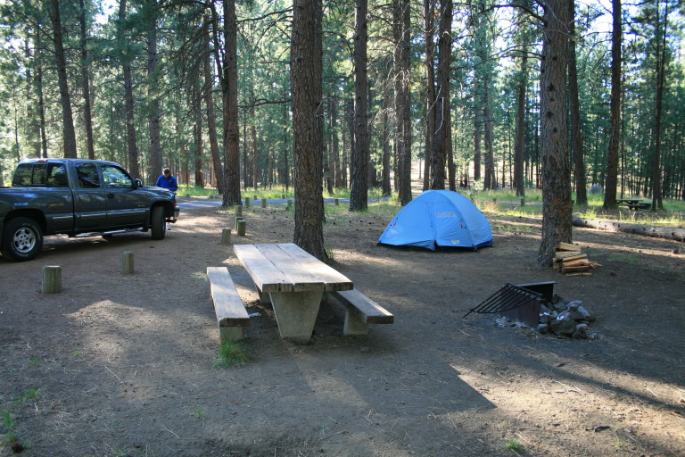
With great effort, I decide not to be just one more silly tourist, overcome by the local Western nostalgia. Instead, we head to our campsite, and start a fire, it would be the only fire we would be able to have this week, and the night was blustery, and cool. In fact, as we were sitting around the fire, the wind blew a large ember into Greg’s hair, unnoticed by him… Then, I had a choice to make. Wait, to see how long it would take for him to burst into flames, or gesticulate wildly, flailing my arms and hands around, trying in vain to blurt out “Fire!” all the while pointing and making strange gurgling noises as the words stuck in my mouth…
Yep, I chose the latter, but it seemed from my agitation that he was able to figure out quickly that something wasn’t quite right, and brushed the offending ash out of his hair. Having saved Greg’s bouffant, I was able to retire with a clear conscience, and slept soundly.
The 46-mile circuit of trails around the third-, fourth- and fifth-highest peaks in the state is one of Oregon’s great multinight backpacking opportunities — and one that gives you plenty of those in-your-face views.
Yes, wish we had more opportunity to hike in Oregon, there are some beautiful places to see! Thanks for the comment!
The trail around Mount Hood is officially impassable at Eliot Creek, so the Three Sisters hike is a good alternative.
Excellent info, thank you for sharing this!
Three night backpack – camp at Camp Creek Trail junction, Moraine Lake, and a little beyond Sisters Spring.
Thanks for the info!