Ranking: 4/5 Anyone that has ever traveled this trail, will know why it has garnered this ranking. The big views of jagged peaks, trails that wind around several sub alpine lakes, and the constantly changing scenery coupled with the ability to see the Alpine Lakes Wilderness an hour away from Seattle, should rank high on anyone’s list.
Difficulty: 6/10 There is enough elevation gain to satisfy those that need some challenge, and not so much as to keep beginners from feeling defeated. The maintained trail does end at Lower Wildcat Lake, but the faint fishermans trail is relatively easy to follow, also once you venture beyond Gem Lake, it is truly Wilderness travel for there are no designated campsites.
Maps: Use the Alpine Lakes Protection Society (ALPS) map, that can be purchased from REI. A great map of the area, and it’s tear resistant and waterproof. Also, the Green Trails Map, #207 Snoqualmie Pass.For more info, go to the Mt. Baker-Snoqualmie National Forest website, and look for trails on I-90, the High Lakes Trail #1012.
Permits: Will need a Northwest Forest Pass, or equivalent to park at the trail head. Also, will need to self register at the trailhead.
Day 1.
7.1 miles 2517ft gain/1407ft loss. It’s nice to have a hike that’s close to home, for a change. Usually, if we wanted an early start, this required us to either leave in the dead of…Early morning, or leave the day before and find a good place close to the trailhead to make camp. However, this hike starts in the Alpental Ski resort parking lot, up on Snoqualmie Pass, so I was able to leave from home, and arrive at 10:40am, a nice reprieve from hours of driving.
The parking lot is huge, and there were already several cars, so I was worried that there might be some difficulty in finding a spot tonight. The starting elevation is at 3112ft, and the final destination today at Upper Wildcat Lake, is at 4224ft. This shouldn’t be a huge day for climbing upward, so I plan on taking my time, and taking lots of pictures.
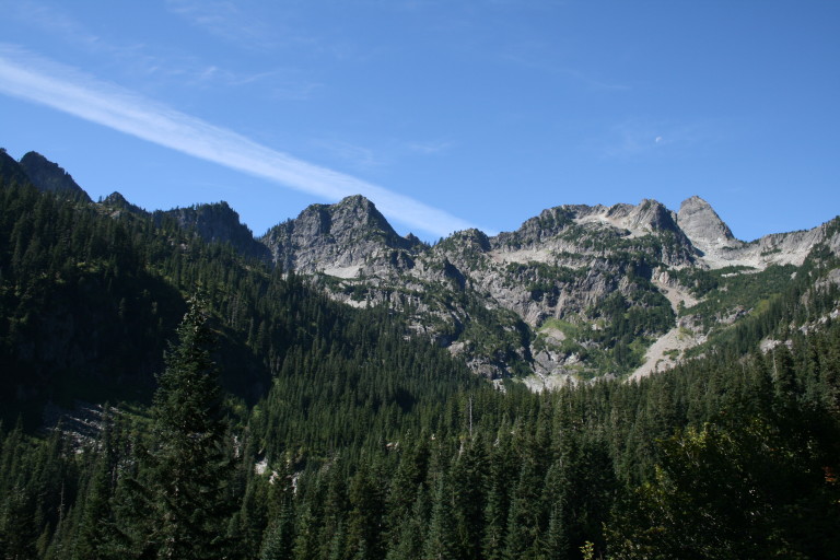
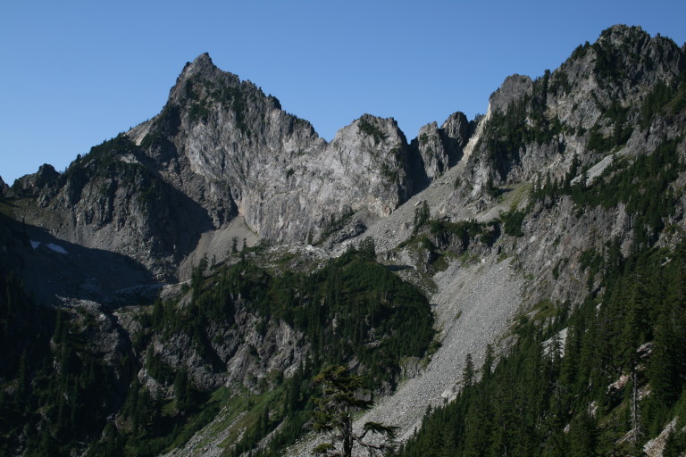
…The steep vertical slopes of these arrowhead shaped mountains remind one of more distant and famous peaks, perhaps even the namesake of the local ski resort, the Alps…
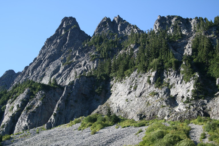
Loading up, I head up the trail, and it’s a nice gradual start through forest, with an occasional clearing as you cross large talus fields. From these clearings, you are able to see some of the dominant peaks in the region, as they streak upward. The steep vertical slopes of these arrowhead shaped mountains remind one of more distant and famous peaks, perhaps even the namesake of the local ski resort, the Alps. At 1.7 miles in, you reach a trail junction that heads upward, and there are several switchbacks uphill that take you to the saddle before dropping down into the Snow Lake basin, at 2.33 miles.
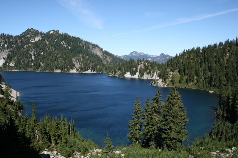
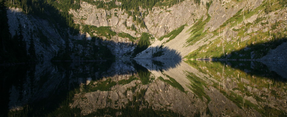
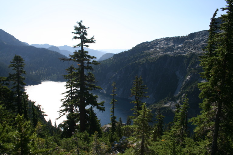
You are gaining about 510ft in a little over .6 miles, so it’s fairly steep, but the switchbacks are good at taking out the slope. Once you get to the saddle and start down into Snow Lake, the views from the trail in places are awesome, as the trees part in the right places to give you a birds eye view of the lake. It’s very large, and set against steep granite slopes that lead away from where the trail comes over the ridge, with open views across the lake to valleys and mountains in the distance.
It truly is a beautiful lake, and I begin to appreciate why the parking lot is so huge. For here, close to Seattle and within a short hike’s distance, is a gorgeous, deep blue sub-alpine lake. On the eastern banks of the lake, are several campsites and a day use area, and I notice that there are many small children backpacking for perhaps the first time with their parents, a wonderful indoctrination into the backcountry.
…I can only assume, given its name, that this is an annual occurrence…
From a rock outcropping about mid lake, just past the majority of campsites, I pause to take in its splendor. The lake sits at the base of Chair Mountain, and at the far end of the lake, there is still a large snowfield sitting at the bottom of the bowl of granite surrounding the far shoreline that touches the water’s edge, still feeding the lake with fresh snow melt. It’s amazing to me that at this relatively low elevation of 4016ft, and this late in the year, there would still be snow fields, especially as large as this one. I can only assume, given its name, that this is an annual occurrence.
…There are no shortages of talus fields here, and the trail will cut across several of them. Once you reach Gem Lake, you’ve reached your highpoint, at 4922ft…

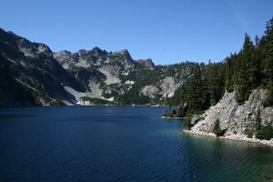
After my break, I leave the Snow Lake area, and continue along its shore, until the trail begins to head up once again, through small meadows like stair steps, small pockets of green that push back all the granite that is in large abundance here. You remain in the open along this high ridge along the lake, and it allows you to see across Snow Lake to Chair Peak, and the rugged region that you are heading up into. There are no shortages of talus fields here, and the trail will cut across several of them. Once you reach Gem Lake, you’ve reached your highpoint, at 4922ft.
This seems to be the destination for most people that head out on this trail, and who could blame them? The name given this lake is fitting. It’s perfectly shaped, and with the sun glinting off of its slightly rippled surface refracting sunlight with sparkling brilliance, it truly gives one the appearance of a finely cut gem. Trails run everywhere here along the banks of Gem Lake, and there are several areas to camp in.
…and the most prominent of them is Kaleetan Peak, another jagged, granite point piercing the sky…
Walking through the small meadows towards the far west end of the lake, you’ll find a spectacular viewpoint across to the peaks on the other side of a steep valley, and the most prominent of them is Kaleetan Peak, another jagged, granite point piercing the sky. Also from this vantage point, you are now well above Snow lake below, and have sightlines all the way back to the saddle that you crossed over to first drop down into Snow Lake. You will want to take this small side trip to enjoy the impressive views.
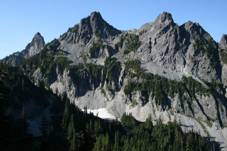
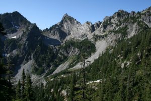
There are several trails running off towards the stony peaks, so they might be climber’s trails to scale them. I keep moving around the lip of the lake and after reaching the far shore, the trail climbs slightly up over another talus field, and then you’re over the top, and you find yourself winding downward steeply, switchbacking down a rocky hillside. Before the descent, you get a good look at what you’re about to drop down into.
Wow, is this place rugged! Steep granite mountainsides with bony ridges and peaks, have dropped huge quantities of granite in rock landslides everywhere, partially filling the valley floor below you with massive flows of jumbled stone. Trees have difficulty growing on their steep flanks, leaving bare granite exposed, like bones bleached white from years of exposure to the elements. Down, down, down, the steep switchbacks, and I’m already dreading the climb back up…
…this was my original plan, to camp here along its shores. I’m dismayed to find almost nothing…
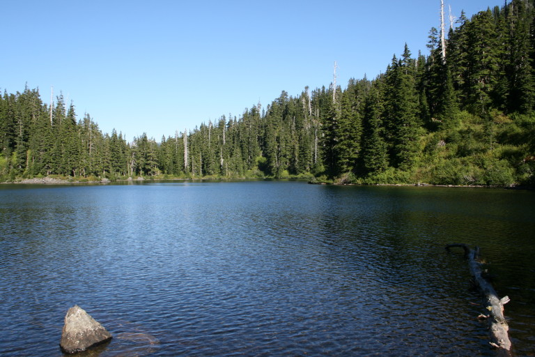
Once at the bottom, after crossing the massive granite boulder fields that lay piled up, the trail once again enters tree line, and skirts along the shores of Lower Wildcat lake. I begin to look for a campsite, for this was my original plan, to camp here along its shores. I’m dismayed to find almost nothing…Before I even get a first view of Lower Wildcat, I cross a stream under the forest canopy, and there is a spot that looks as if it has been camped in, the ground is flat here, and beaten down, as if tents have been set up here before. I make a note of it, but really don’t want to spend the night here, as it straddles the trail. Finally, the trail seems to peter out in a small clearing, and this seems to be the only site along the banks of the lake!
Everything here is overgrown with brush, and you have to wade through it for about 30 feet before reaching the edge of the lake to get a good view. The lake is pretty nondescript, and all of its banks are encroached upon by woodland. I am disappointed, for this does not look like what I had hoped it would be. I’m surrounded by forest and brush, and this small site at what seems to be the end of the trail is not even level!
He assured me that the upper lake was not only more scenic, but there were more places to pitch a tent.
As I’m pondering this most unsavory turn of events, a day hiker steps out of the brush from the other side of the outlet stream, and says hi. I had planned on setting up camp here, and then hiking up to see Upper Wildcat Lake, and so I asked him what the upper lake was like, if there was any place to camp. He assured me that the upper lake was not only more scenic, but there were more places to pitch a tent. Seems that there were already some people up there, but there might be other places to camp as well. Sure sounded like better options than I had right now, so I thanked him for the info, and crossed the outlet into deep huckleberry brush, following the faint trail that led up to Upper Wildcat.
The map that I had did not show a trail up to the lake, but it is a relatively easy fisherman’s trail to follow. In only 20 minutes, I make the shoreline of Upper Wildcat Lake, and am overjoyed that I continued on! The first spot you reach when getting to the lake, is by far the best, with commanding views of the lake and surrounding ridgeline, dominated by Mount Roosevelt on the far shore. This site is on a knoll next to the outlet stream, and wide enough for several tents. Its occupied by a couple of guys that lugged in small inflatable rafts so that they could get out into the middle of the lake and fish, and they planned on staying until Monday, so I edged through their campsite, (the trails here seem to join one site to the next with the lakeshore trail), and made my way around the northern shore until I found a good campsite near the water, maybe only a 100 yards from this first place to camp.
…I set up camp, and the 3 man tent that I brought, (yeah, I know it was overkill, but it’s all I have!)

Above the place that I chose, on the connecting trail, was another campsite hidden in the trees, but I liked this one much better, as it was close to the water’s edge. I set up camp, and the 3 man tent that I brought, (yeah, I know it was overkill, but it’s all I have!), and looked around. There was a nice sandy beach here, even though it was narrow, it was still welcome, and the sand looked as if it extended into the water. There was some debris here close to shore, but not bad, so I took a dip to get clean.
The water was cold, but bearable, so I was able to stay in it long enough to rinse off the day’s sweat and grime. Thankfully, there was still some heat left to the day, and I find a nice rock to sun myself on, letting the sun’s rays dry me and my wet clothes. Ahhh…Another nice feature to this lake is the way that it is protected here from the wind. You can hear it roaring across the treetops behind me, and see it swirling in the farther reaches of the lake, but here it’s only a gentle breeze, which allowed the sun’s rays to have some heat… Across the surface of the lake, I can see and hear the guys fishing from their rubber rafts. Near the southern shore line, is a small rocky island with some trees growing on it, almost looks large enough to camp on, if you could get to it by wading.
I never ventured over there, though, as the day began to wane, and there was a couple staying somewhere over there, I could see them when they came to the lake’s edge to get water. The boat boys finally come back to shore, as it’s starting to get late, and I wander over to filter water from the outlet stream, and to say hi. That’s when I find out they are staying until Monday to fish. I thought it pretty industrious, to haul heavy inflatables this far in. They had some luck, one of them caught a nice trout that they had planned to have for dinner.
…It’s then, after settling down, that I really notice my neighbors…Loudly…
Back at my camp, I also prepare my meal, take a few more pictures of the area, and sit down to relax, and watch the last of the day disappear over the sawtooth ridgeline above, retreating quickly as dusk, and then night take over. It’s then, after settling down, that I really notice my neighbors…Loudly…I usually bring my Zune so that I can listen to music during the evening, to give me some sense of companionship, and I could hear them over the music playing in my ear buds! They start a fire (something that shouldn’t be done here), and start talking boisterously about the day, loud enough that I can hear everything they’re saying. Part of me really didn’t mind, though.
“Dude! Look! They even wrapped it like a real ice cream sandwich! Unreal, man!”
The glow from their fire was enough to cast dancing shadows across the trees of my campsite, and their enthusiastic conversation about the freeze dried ice cream sandwich and how it tasted, were enough to bring a wan smile to my lips. “Dude! Look! They even wrapped it like a real ice cream sandwich! Unreal, man!” You couldn’t help but grin, listening to their banter. Funny, even here, miles from civilized life, you can’t get away from the sounds of city life, or the feeling that you are surrounded by people. And here, I thought I was hiking alone…They were still going at it around 11:00pm, glad to have my Zune to help drown them out, so I could get to sleep.
…it doesn’t appear to be a catastrophic failure, probably due to the fact that David failed to properly screw the lid on tight…Curses!!!
During the night, I wake up to find that my Camelbak had leaked again! This is the second time now, I’ve had it leak inside the tent, and get everything drenched in Gatorade! What a mess! This time, though, it doesn’t appear to be a catastrophic failure, probably due to the fact that David failed to properly screw the lid on tight…Curses!!! Thank goodness for spare clothes, for they serve as a mop…