Day 2
17.3 miles, 4481ft gain/4481ft loss…Fitbit steps: 46,107 Yep, that’s no typo…Almost 18 miles, and a whole bunch of ups…Of course, I didn’t know it at the time, thought it was going to be more in line with 14…Not that it would have changed anything, probably still better to not have known…
“…Just like the feeling you get when you get on the Tilt-O-Whirl at the county fair and look at the immaculately manicured individual pulling the levers on the fun machine you just parked your backside on…”
Packed up lightly and on the trail by 7:30 this morning the trail continues through more rainforest past monster trees at a slight uphill to a bridge over seriously troubled waters at 3.27 miles. As I walk out onto the bridge, I can’t help but suck in my breath, and let out a “holy crap!” This baby is a looong way off the deck! When you walk out to the railing and look down off the side, it will give you a serious case of vertigo… It looks to be close to 80 to 100 feet down into a cut in the rocks on either side, and it makes you wonder just how in the world they put this bridge in. It’s a metal frame that spans this gap that must surely have been airlifted in, and then covered in planking. Standing here, looking down into the abyss, you begin to wonder, “Gee, wonder when the last time this thing was maintenanced or inspected?” Just like the feeling you get when you get on the Tilt-O-Whirl at the county fair and look at the immaculately manicured individual pulling the levers on the fun machine you just parked your backside on…
Pictures from the bridge deck hurriedly taken, we get to the other side, and begin our long ascent uphill. And I do mean long…For the next 3 hours approximately, its nothing but a relentless slog uphill. Not always steep, but just always up. In fact, as I would find out once I got home, over the next 5.27 miles of constant up (yep, 5.27 miles of always going up!), you gain 3841ft of elevation! Not quite at the 1000ft per mile steep, but still…it’s 5.27 miles UP!!!
At 4.85 miles, there’s a small step and a camp called Martins Creek, and then you reach Elk Lake and its shelter just a ¼ mile later, which was under repair when we got there. Elk Lake is really nothing much to write home about, from what we could see through the trees, it looked like it had a lot of vegetation growing around its banks, making it look uninviting to swim in…Still, it seemed there were quite a few campsites on this side of the lake, where the trail led. The trail is still good, but noticeably rockier, rootier, and narrower…Okay, maybe “rootier” isn’t a word, but I know you know what I mean…
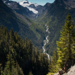
At 6.5 miles, the trees become thinner, and the trail now balances on the edge of a very long and steep mountainside, one misstep here and you’re gonna tumble for a long ways. Its cut right out of the side, so it’s got a narrow tread path, and gets you real focused on what you’re doing. It’s along this narrow section that you have great sight lines towards Mt. Tom and the Glacier Creek drainage to your west. Also, you get a pretty good shot of Snow Dome on Mt. Olympus.
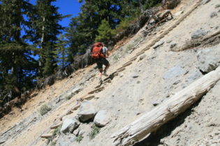
At 7.19 miles, you reach a slide that wiped out a portion of the trail here, and the fix was to install a cable ladder with a rope assist to get you over this very steep washout. It’s maybe on 60-70 feet long, and something we’ve never tried before. Very interesting, and cool at the same time. Not sure it would be so cool during a rain, though, turning this into mud…
After you make it safely to the bottom, you clamber back up the ravine to join the trail again. Now it’s only about a half mile to Glacier Camp, a place here in the trees that climbers usually use. It’s got a couple shelters, toilet, and a ranger station, that’s really only a wooden circular platform that I suppose you could set a tent up on…Just beyond the small meadow here ringed in trees, is a trail junction, one to the terminus of the Blue Glacier, the other continues up to the moraine ridge, that borders the NE side of the glacier. From camp here, its’ a steep 1 mile and about 900ft of elevation gain to the edge of the ridge where you gain access to the glacier. This is also the route the climbers use.
“…the massive ice flows coming from the upper heights, jumbled and cracked like a giant waterfall frozen in time…”
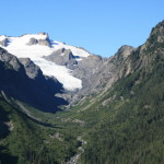
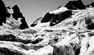
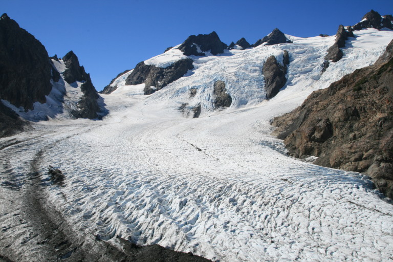
Finally, at around 12, we reach the top of the ridge, our high point for the day, at 5130ft elevation, and 8.6 miles, and suddenly it all seems worth it. As you crest the top of the moraine ridge, you get to stare down onto the surface of the Blue Glacier. It’s an impressive frozen river flowing ever so slowly from the base of Mt. Olympus, with large creases opening in the middle, the crevasses glowing with the blue of deep ice. Following the flow of ice upwards, you can see the massive ice flows coming from the upper heights, jumbled and cracked like a giant waterfall frozen in time. It’s amazing to get to see all this ice up close, and we just stand here for a while marveling at the sight.
After taking several pictures, we decide to make our way down this ridge of built up moraine from eons of the glacier depositing it here as it made the bend. Heading down, it’s a pretty steep descent that drops 280ft from the top of the ridge down to the ice edge. It’s hard to imagine climbers doing this at night with their headlamps on, for even during the day, there are a few sketchy places that want to slide out from under you. We take our time, not wanting to disturb the fragile footing for the next guy, and also to not bean whoever is on the downslope side…
“…like jumping out of a car at 30mph on pavement…”
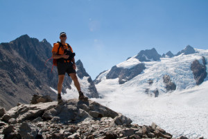
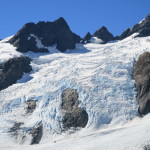
Safely on the ice, we wander out into the frozen blue waves to get some good pictures. The ice is solid and easy to get purchase on, even if there is running water everywhere. The surface of the ice is like barnacles, if you were to fall on this stuff, you most certainly would get scuffed up pretty good, like jumping out of a car at 30mph on pavement. Just kneeling, touching my bare knee to the surface, it came away bleeding…
The wind blowing down over the ice and hitting us in the face is cool and refreshing, especially on a hot afternoon after a long hike up. In the distance, you can hear either rock or ice falling as a reminder that things here are in constant flux as the ice makes its slow journey down the mountain.
Looking at our watches, it’s time to get back to camp as it’s now 1…Taking a last few looks around, not wanting to leave just yet, we reluctantly begin the long trudge back to camp. Up the moraine ridge, back towards where you first come up the trail we meet 5 guys that had come up after us, and one of them mentioned that they had tried to keep us in sight as we ventured out onto the ice, but said it was hard as we were just dots. Another reminder of just how huge the glacier is. You don’t really “see” how large until a person is in the frame for perspective…
Down, down we go. Coming down the ladder was fun, but going up took a bit more work. In fact, we were both breathing hard after getting to the top. Reaching the top, It was hard to talk as you were busy sucking wind. Wow, that was surprising.
We settle into a long trudge back down, doing our best to save our knees, and after about an hour or so, we stop for a second to chat with a couple guys that were going to climb the mountain tomorrow, and they asked us a few questions. One was how much longer to Glacier Camp. “Oh, we’ve been on the trail coming down now since 1, and it’s 2 now, soo…You’ve got about an hour to go”…
“…and we continued on, leaving them to their misery…”
“AN HOUR?!” the one guy said, looking at me accusingly, as if it was somehow my fault that the trail never seemed to stop going up…I smiled, and said, “yep, and that was coming down, so it might even be a little longer”, needless to say, he wasn’t smiling…They thanked us for the beta, (at least one did, anyway), and we continued on, leaving them to their misery…
After 2 and a half hours of constant down, feet, knees, and back were never so glad to see the bridge again, as we knew that would signal an end to the knee burning constant downhill..
We struggle into camp around 4:40, and tear off boots and packs and just sit there for a bit, glad to not be moving…Since we got into camp late, there’s not much time to lounge, so we repeat the procedure from yesterday to get water and get prepped for dinner.
Greg has again brought a new recipe with him, called Thai Peanut Noodles with Chicken and Veggies.Looks fairly easy to prep and cook, and boy, is it delicious! All the ingredients are premixed at home, put in a gallon zip-lock baggie, then all you have to do is add boiling water at camp, and voila! Your own instant meal! Another winner!!! thanks Greg!
Cleanup, then as we’re sitting watching the darkness slowly creep up and surround us, Greg hears a rustle in the gathering dusk, and about 15 feet from where we’re sitting, 4 does and a fawn walk by. First large critters we’ve seen this hike. They don’t stay long, just passing through. We talk for a while, watch the stars appear, and then decide it’s off to bed, after a long, long day…