Day 2
17.42 miles, 4916ft gain/4782ft loss. Fitbit data: 45,380 steps, 466 floors.
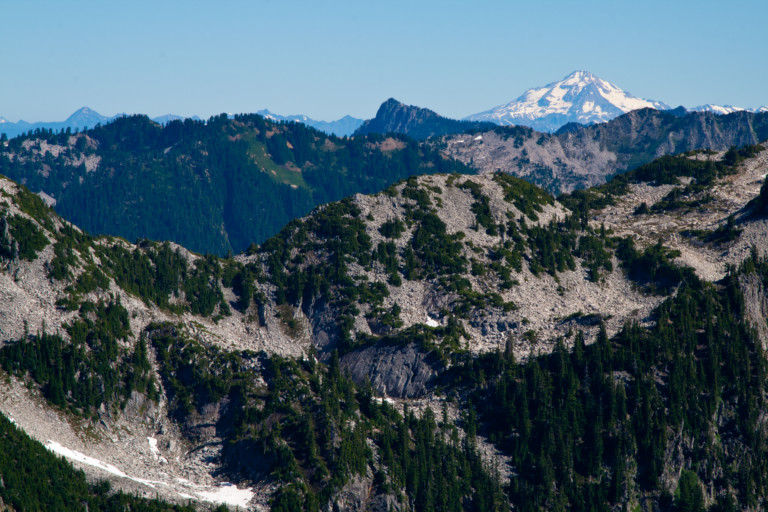
Another cloudless day! After our morning ritual of pushing a cup of joe around for a few to open the ol’ peepers, we’re watered up, and ready to go. And it’s a good thing we’ve filled our camelbaks to busting and brought a water filter, for 90 to 95% of today will be out in the open, along exposed ridge line, under full on sun…Again, the way begins downhill over rocky tread, high above Alaska Lake, just beyond our leaving the shores of Ridge Lake. It, too, is a brilliant blue, with sparkling ripples dancing across the surface, reflecting the sun’s rays. Just beyond the eastern edge of the lake, we get peek-a-boo views of Mt. Rainier, fitting between the cracks of the pinnacles of Kendall Peaks. Further south, we can also see Mt. Adams. The trail continues to side-hill along ridge after ridge, all the while providing excellent views of the surrounding peaks.

At 1.65 miles, we come to a small saddle on the shoulder of Alaska Mt., and now we can see what the other side of the ridge we’ve been sidling along has to offer…There, below us, is Joe Lake, with a large snowfield on the opposite bank. It must sit about 1000ft below us, blue green waters shimmering as the wind whipped ripples reflect brightly back. The opposite side of the lake rises steeply and culminates in a point to form Huckleberry Mt. Perhaps it would have been better suited with a moniker like granite knob, as that’s what it more closely resembled than its current name.
“…Joe Lake is too far down to reach without monumental effort…”

The trail switch-backs, but not steeply, down to a bench that connects this ridge to the one that leads up to Huckleberry Mt., in about ¾ of a mile. This small flat before climbing back up the other ridge is treed with old growth fir and a smattering of others, and it looks as if people have stayed here, as there are a few places with fire rings and bare dirt, as if tenters had camped here before. Not sure why, save a small snowbank melting in the sun to provide water. Joe Lake is too far down to reach without monumental effort, so unless you’d brought your own water, staying here is in essence, a dry camp.

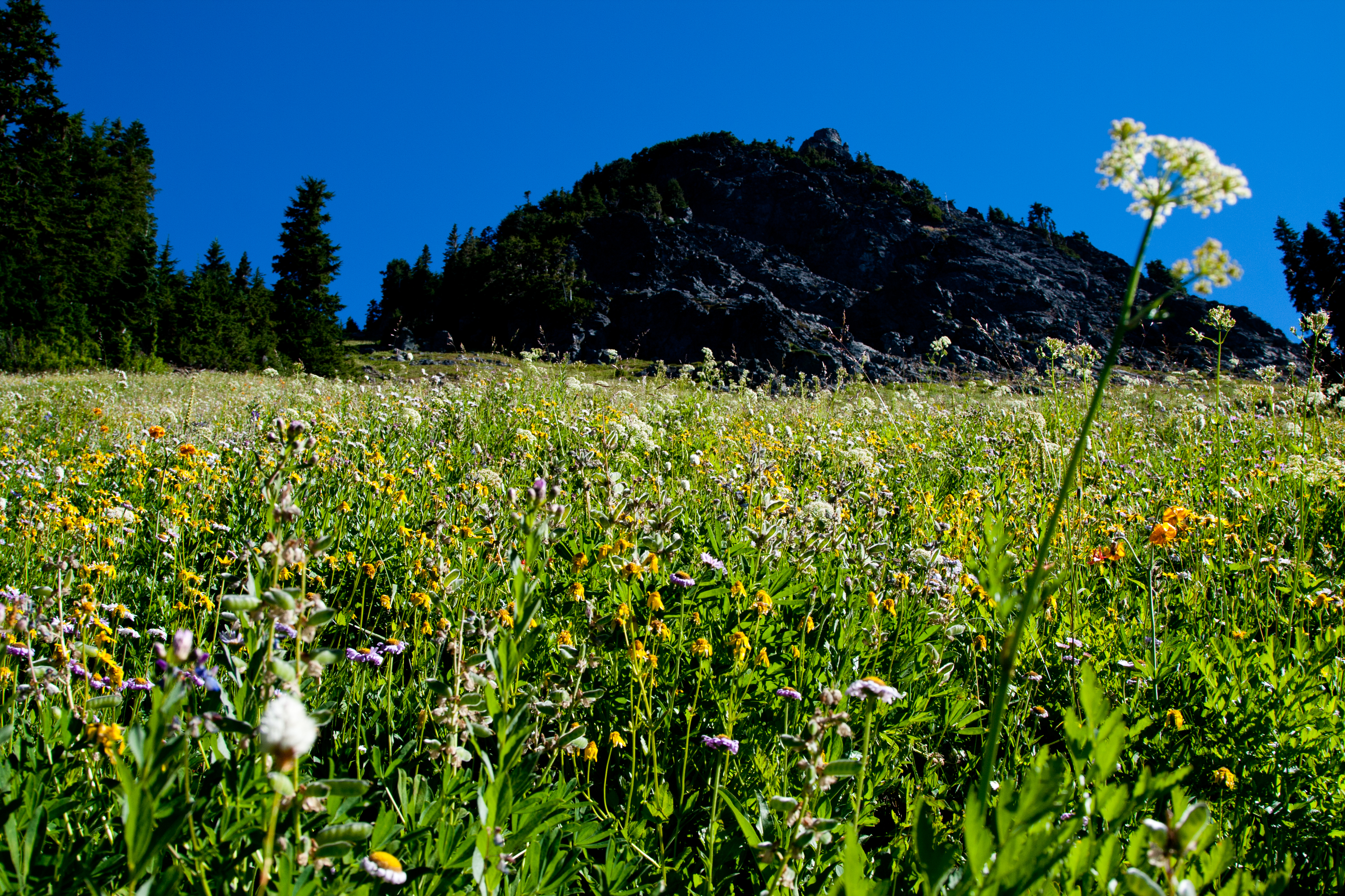
We continue our trudge around the lake, and into another steep talus slope. This one, like so many others along this hike, are filled with wild flowers, the sweet smell of the flowers is mixed with the hum of bees going about their business of collecting nectar. This appears to be a great time to go if you love wildflowers, for every open area that they could grow in; they seem to do so in abundance. The trail continues like this for seemingly endless miles, up then down, as it winds along the flanks of several different ridge lines, the elevation graph of this trail looks like an EKG, or heart monitor graph…
“…Who knows how long the water lingers here…”

Rounding Huckleberry Mt. you come to another small saddle, at mile 3.86, with a trail marker that is weathered and worn, and laying on the ground. It’s so broken up, that it’s hard to read what trail this might be naming, but it looks to say “Neat Pass”, although that may not be what it says, it’s just what it looks like. When I was planning the route at home, I don’t recall seeing this trail on the map. There looks to be a few small pools of water that we take note of, as this being the only real watering hole we have noticed so far. We also see what looks like a possible place to camp amid a small copse of trees just north of the trail junction. As this is a fairly flat bench, short grasses and some wild flowers provide ground cover, around clumps of heather. Who knows how long the water lingers here, all dependent on how much snow melt they got, and how much rain water they can gather…The pothole on the south side of the trail is larger, with deeper and fresher looking water.
“…getting ready to slap some skin with the sun…”
Now, it’s a steady climb again up to the ridge that lies below Chikamun Peak, and the 4 brothers. At mile 5.9, you walk beneath the pinnacles of the 4 Brothers, a distinctive cluster of pointed peaks aiming at the sky, like a high-five (or should I say high-4) getting ready to slap some skin with the sun. Once beyond the 4 Bros, and their shattered remains that lay scattered at their feet (Yep, you’re gonna be crossing a lot of rubble fields), you come to an unmarked trail leading up to a ridge, at mile 7.22.

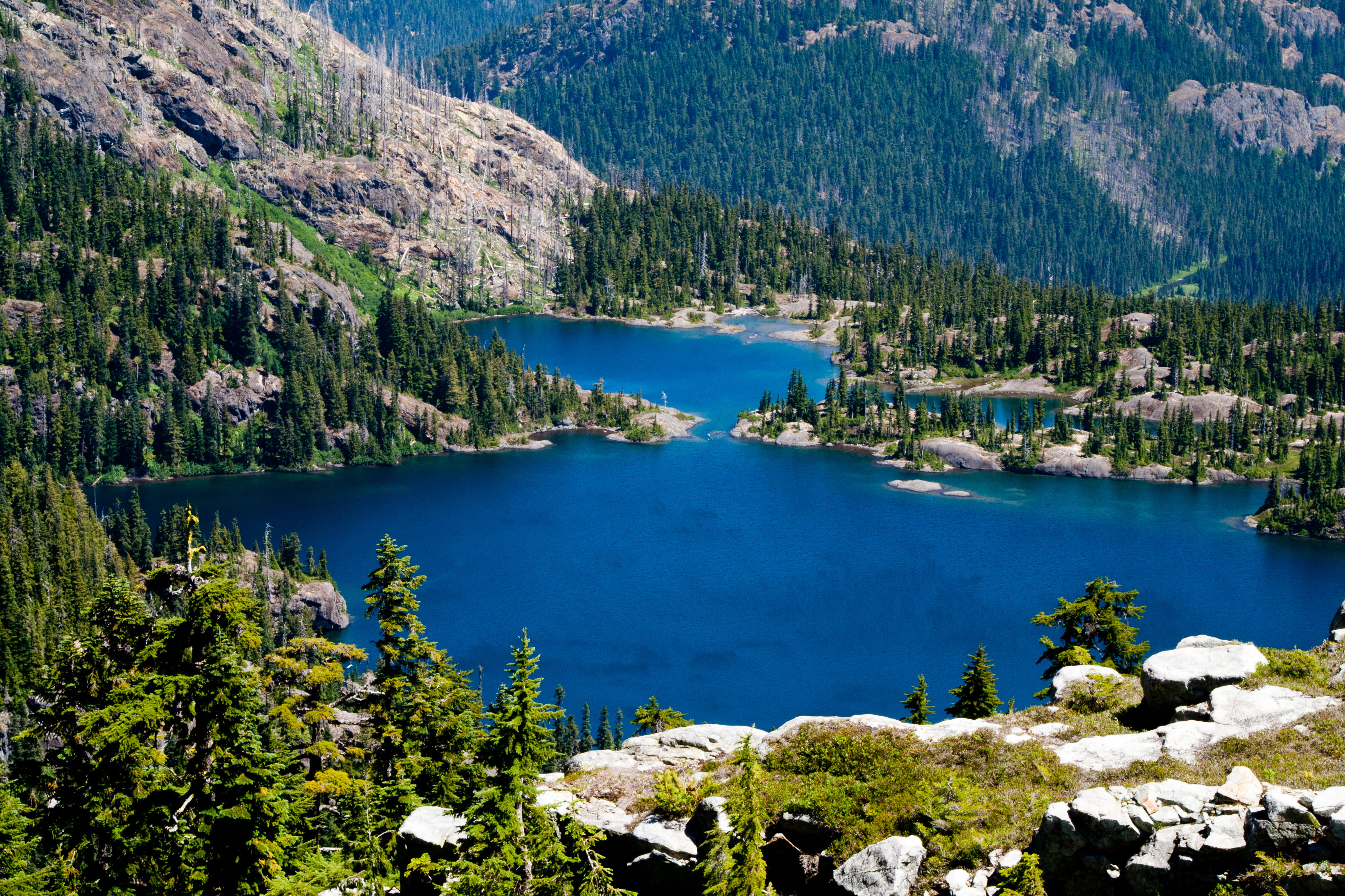
It’s worthy to note, as a quick side jaunt, for once on top, you have incredible views down into Spectacle Lake basin, a brilliant blue-water lake, ringed in smooth rock, 2 lakes that are merged in the middle. Sweeping your gaze back up to the west, you’re now looking at the eastern sides of the 4 Brothers, parapets on rugged and jagged skyline, the rock here looking like dragon scales, pointed and menacing looking. Before the rock gets steep, you can see small Glacier Lake pooled at the base. It’s clear to see that this trail leads down to Glacier Lake, and we can only surmise it also connects to Spectacle Lake further down into the small valley. A beautiful looking area, one we’re now intrigued to come back to. The whole valley is ringed in jagged peaks, with two pretty alpine lakes. The eastern edge of this valley is open and you can see across to neighboring Chikamin Ridge.
Back on the trail again, now it’s only about 1.6 miles to Park Lake, for a total one way distance of 8.8 miles. Before reaching the lake basin, on your final descent, you’ll round a prominent bend, giving you sight lines down into Park Lake, and the surrounding meadows. The multi-colored hues of the lake almost give it a gem like quality, like that of a sliver of polished stone. In the middle of the lake, the deeper waters are the deeper blue that is familiar with the previous lakes, but the edges are a brilliant orange, no doubt from mineral content, then they fade to light turquoise then the dark blue. Reminds you of a hotspring you would see in Yellowstone.
“…Why camp here if there is room at the lake?”

Following the switchbacks downhill into the lake basin, we make the mistake of turning at the first right we come to, mile 7.76, near a signpost indicating 7 miles to Lemah meadows, and hiker and stock campground that-away…This ends up being a 10 minute detour to nowhere, as the trail meanders a bit into grassy meadows before petering out. This is not the way to the lake, but it does appear people have camped here before, visible by the barren patches in the grass. There are small potholes of water here too, but too shallow to predict if there would be season long water…Why camp here if there is room at the lake? I dunno…Down the trail another half mile, at 8.27 miles in, is the real turn-off to Park Lake, and after a long 8.8 mile huck, we arrive at the lake shore.
“…except for the B-52’s of biting insects, the horseflies…”

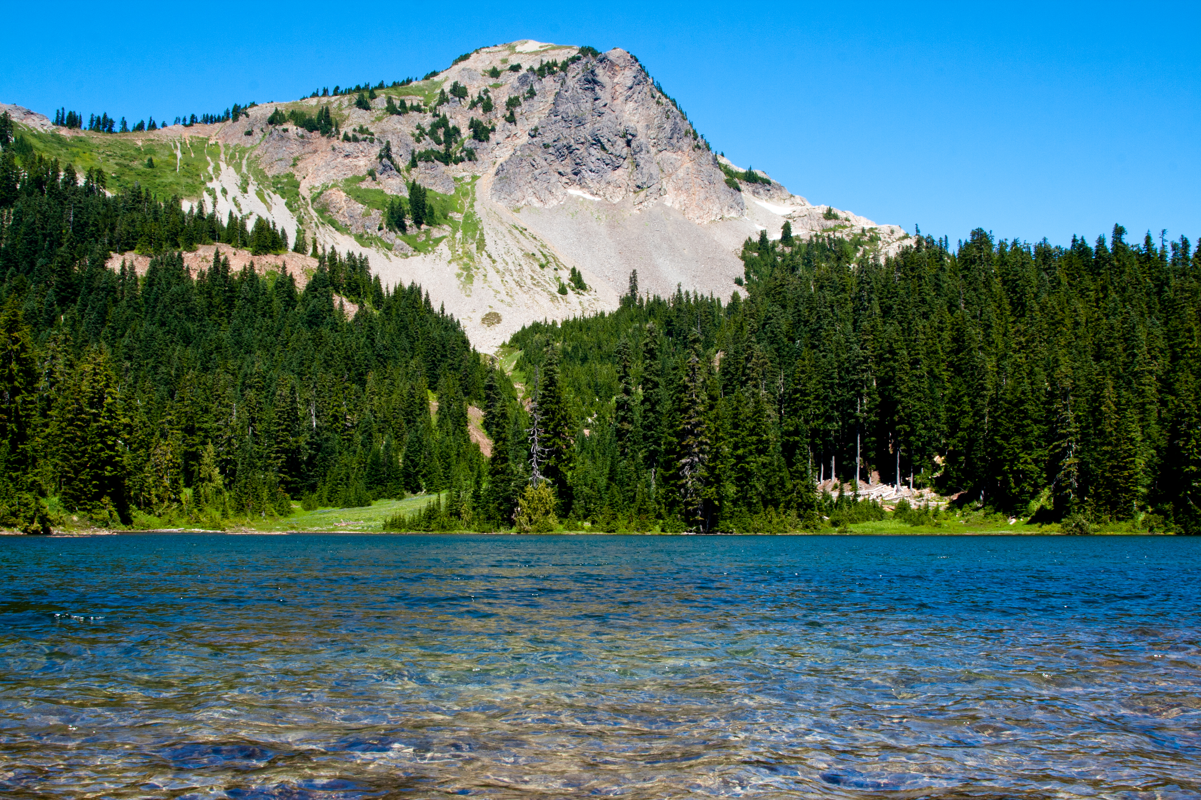
It’s a nice lake, but an 8.8 mile, 3 hour trek worthy?? Nahhh…Still, we set along its banks, and take a break before heading back. The wind continues to blow steadily, helping keep the bugs at bay, except for the B52’s of biting insects, the horseflies. They still seem capable of negotiating the stiff breeze to be nuisance. After swatting a few of the slower ones, and snapping a few pics of the basin, we leave the lake, and begin the long trudge back. It’s still hot, and by the time we reach the point we had noted for water earlier in the day, we have to stop and re-fill. By 4:45pm, we make it back to our campsite at Ridge Lake, and it’s so nice to come back to a site that’s already set up. Feet tired, but not too tired for the short trip to the lake to jump in and splash about. Aaaahhhhh…
“Nature at its finest!!!”
As I was hanging my wet clothes on our makeshift clothesline to dry, we hear a splash on the opposite side of the lake, then the loud proclamation, “Nature at its finest!” What? Was dude reciting the label off of his granola bar? Did he suddenly have an epiphany? And then, as if to re-inforce the notion, again, with more gusto, “Nature at its finest!!!” Now, I look around, expecting to see a possible camera crew filming a new commercial, or something equally whacked out, when it dawns on me, “Wait, was he shouting at me?” Then the affirmation comes, as I slowly fade backwards behind the nearest tree, “Dude, I don’t even know who I was talking to there, “obviously talking to his friend on the shore next to him…I heard other mutterings too, but rather than encourage a shouted conversation across the lake, I chose to melt into the woodwork…Literally…
I tell Brian, “Geez, I think that guy was hollering at me!”, and how do you reply to an obvious statement like that, with another obvious statement? “Are you high?” A Salutation? “Greetings, Earthling!” A gesture, like extending my right hand solemnly upwards, “Live Long and Prosper!” Or, possibly all 3 together??? All these possibilities and more ran through my head, but instead I decided to just not engage…

Dinner over, a little imbibing of spirits, and off to bed with the endless chorus of “Eeeks!” and occasional shrill whistle thrown in for good measure from a lone Marmot to gently lullaby us off to the land of Nod…