Day 2
4.9 miles, 3017ft gain/loss.
Hey, blue skies this morning!!! Awesome! As we prepare to leave base camp and head up to explore Jade Lake above, we are hopeful we will get good clear pictures of the lake and surrounding mountains.
“…You’ll know you’re in the right chute by the orange colored scree field, visible from the camp side shoreline. Again, keep to the cairns…”

After a hearty breakfast, the three of us pack light and head up the trail that skirts the west side of the lake. It’s more of a game trail than a hikers trail, but still relatively easy to follow. However, when you get to your first draw, a scree and talus strewn ravine, look carefully for small cairns, as these will mark the correct way to Jade Lake. Many it seems have followed this draw up to the lake, a much rougher scramble than is necessary. Keep along the shoreline after this first ravine for another .3 miles until you reach the true route up. You’ll know you’re in the right chute by the orange colored scree field, visible from the camp side shoreline. Again, keep to the cairns.
Climbing up over the first little bench, we observed cairns to the left and right. Looking up, it seemed clear that either way would get us there, so we stayed to the right of the draw, closer to where the orange tinted rock had run out from the ridgeline. Now, it’s a boulder hopping scramble to the top, and as we get closer to where it flattens out, a soil ridge has cleaved the boulder field, and we can see a well-defined trail following its spine, amidst low growing heather and meadow grass. A short walk later, and you’re standing in a small flat meadow area, and we see towering peaks streaked with clinging snow on either side, protecting this small valley.
The pink heather pops against the greenery that grows close to the ground. We first see a small tarn, not more than a foot or two deep, and it’s still surface reflects sun and surrounding peaks. Over a small rise, and we come to No Name Lake, at 1.25 miles, and 5640ft elevation. Again, the surface is calm, and reflects the dominant peak of the area, itself having no name discernable on the maps, anyway…This is truly a beautiful place, and we’re happy to see the sun out, although we’re starting to see the thunder heads creeping in behind the ridge line to the south.
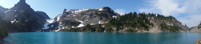
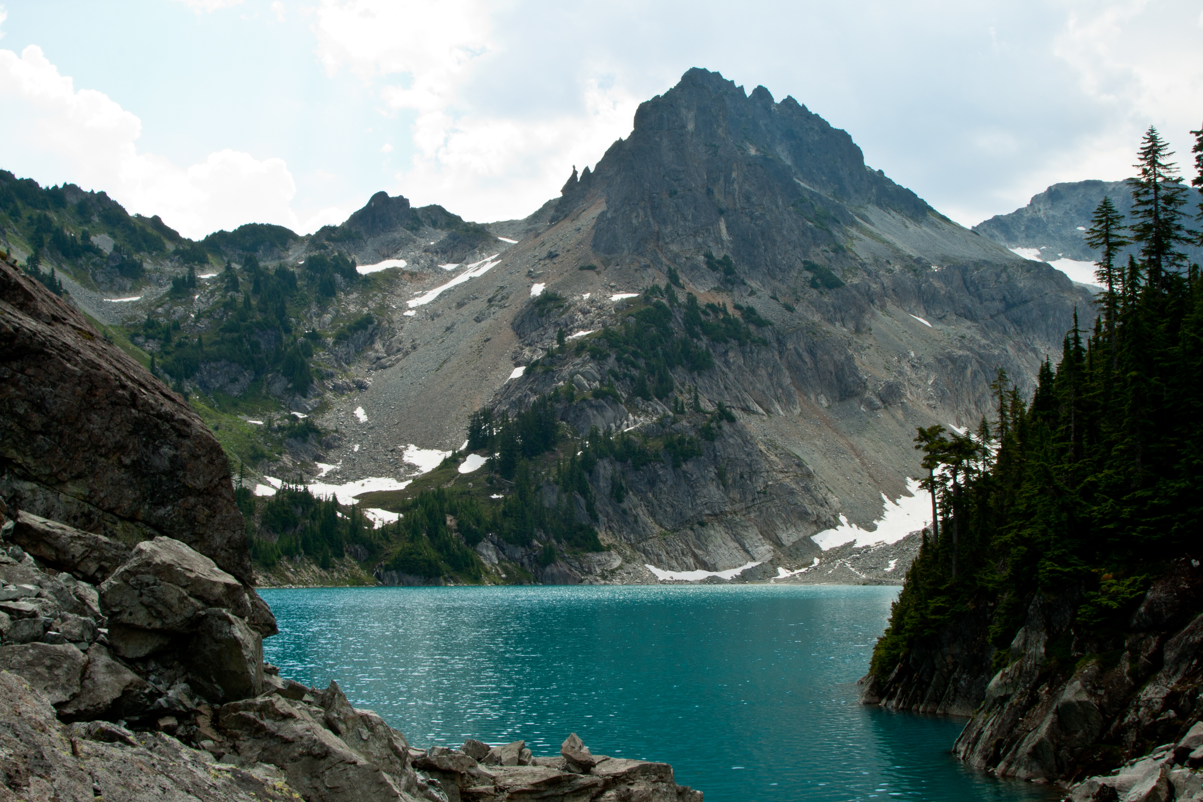
“…and its turquoise waters are stunning, almost seeming out of place…”
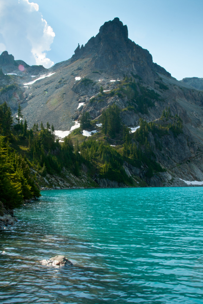
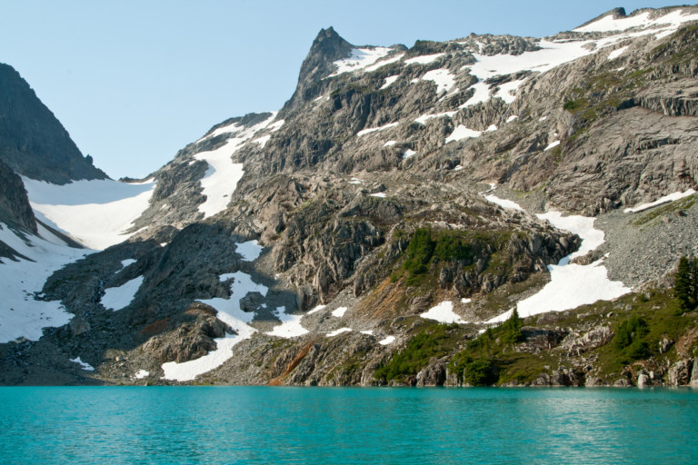
Just beyond No Name Lake, we catch our first glimpse of Jade Lake, and its turquoise waters are stunning, almost seeming out of place. Glacial flour must be the cause of its milky translucence, and beautiful blue-green color. We make our way down to the shore, where a small waterfall draining upper No Name Lake spills into Jade Lake. The lake is hemmed in by granite on its south and east banks, and at its head to the south is a chute filled with snow, cutting a channel through steep ridge line on either side. Our access to the lake is a stepped meadow that leads to the east shore, the only flat shoreline. The outlet of the lake is at the north end, in a steep V shaped notch.
This view, with massive thunder heads massing overhead, peering with keen interest into this granite challis, made the entire hike worth it.Snapping lots of pictures in hopes a few will turn out and really capture the color of the lake, we look around. Now what?
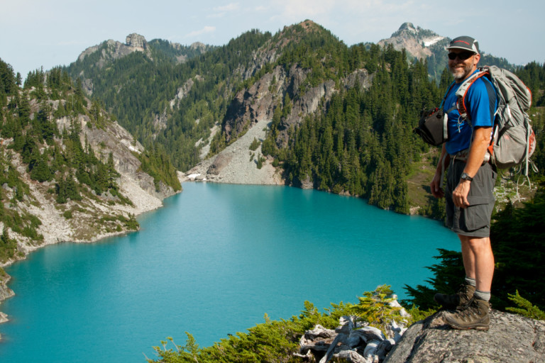
It might be interesting to see what’s on the other side, so we hike up the along the west shore, along a narrow but defined trail, and come across the father and son team we passed by yesterday on the way up. They’ve picked a great campsite next to the lake, on a bare promontory overlooking the lake below. After a short conversation, they decide to join us as we follow the tree lined ridge leading up between the dominate spire along the ridge and the lake. Reaching the top gives us an eagle eye view back over the lake and from this vantage point, we can see distant snow covered Glacier Peak to the north.
“… and without crampons, many not be doable…”
We’re hoping to possibly traverse the snow field in front of us, but it would take better gear than we’ve brought. You can tell from here the snow is steep as it rises to go over the crest, and without crampons, many not be doable. Instead, we opt for a route all the way around the lake, especially with the ever increasing threat of more thunder storms on the way.
“…as thunder announces the arrival of an impending storm…”
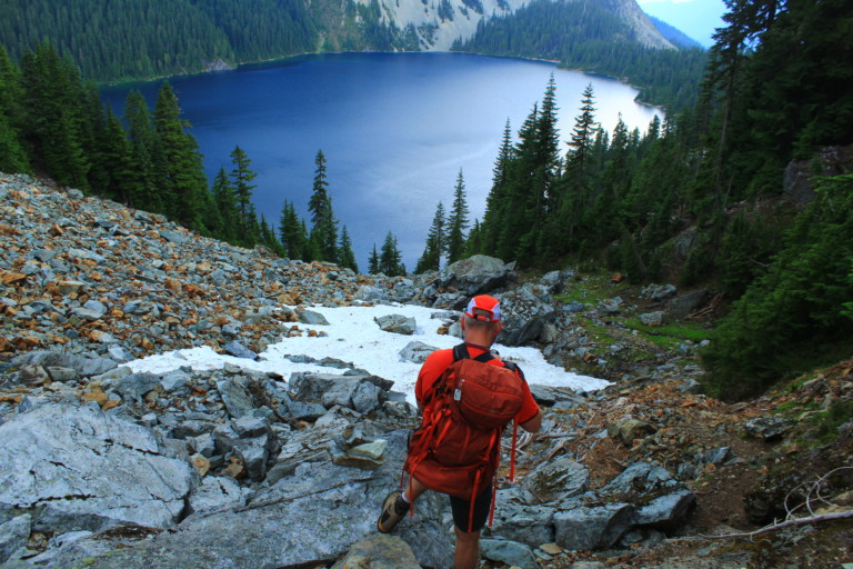
We bid farewell to father and son, and head down a steep goat trail to the bottom of the chute, crossing the braided stream to the opposite band of the lake. Crossing the ravine, you could feel the temperature drop as the approaching storm forced cool air down the chute over the snow. It was refreshing, but also a reminder that we may not have much time left before the weather would change… It took a little effort and a couple different routes to find a safe way down to cross the outlet, but we found a way and made it back to our starting point just as the clouds really started darkening. Now, hurrying we make our way up and over the flat meadow valley by No Name Lake as thunder announces the arrival of an impending storm.
We stick to the trail this time, which stays to the east side of the ravine instead of scrambling over the boulder route we took on our way up. This is clearly the better way, allowing us a quick retreat from the heights above. Fat drops begin to fall, amidst bright flashes from the angry skies overhead. Looks like we might have left just in time, as we reach the treeline before the clouds let loose. Thankfully, the tree canopy keeps us mostly dry, hiding under the shelter of large branches like umbrellas.
“… A great excuse to take a nap, I think…”

We stay under the protective branches until the worst passes us, and then return to camp. The sun makes a brief return, and during this respite, it’s time for another dip in the lake to rinse off. We’re barely dry before the sky darkens up again and we have to beat a hasty retreat to the tents, where we hide out from a considerable downpour for the next couple hours. A great excuse to take a nap, I think…
During our forced exile to the tents, we hear voices of new people arriving. They take the spot vacated by the couple by the giant boulder, and set up camp during the deluge. Once the weather subsides a bit, we all venture out of the tents, (rain gear donned, of course) to see if the weather will lighten up a bit, and meet our new neighbors. These two have brought fishing gear as well, and there they sit, with rain gear on, fishing, not bothered at all by the recent wetting. We talk a bit, and while we’re prepping for dinner, one of the guys catches the biggest trout I’ve ever seen from a high mountain lake, must be close to 16 inches! I’m used to seeing nice pan fryers, nothing quite this big! Looks like they’ll have a nice dinner tonight. I make a mental note to see what they’re using, and it’s Powerbait (pink) on a foot long leader…
“…it actually starts pelting us with pea sized hail!”
Greg cooks up another masterpiece for dinner, although we have to do it under the constant threat of rain. In fact, at one point amidst a thunder and lightning barrage, it actually starts pelting us with pea sized hail! Again, the trees serve as shelter from the downpour, and we eat our meals for the most part standing under the branches.The skies relent by the time dinner is over, and allows us to clean our dishes and hang the bear bags in relative peace.