Day 2
14 miles 4246ft gain/3344ft loss. Fitbit Steps: 45,980 You know, it felt cold during the night. I remember pulling on my balaclava as my face got cold, and after unzipping the rain fly, I would have visual proof without looking at a thermometer to how cold it was. Ice had formed over the entire surface of the tent. The grass, too, was frozen and white, and after emerging and looking around, we could see fresh snow on the upper reaches of Mt. Anderson that looks down on Honeymoon Meadows. Brrrr….
“…Now, it seems more inviting than its name suggests, especially since our night spent in the open, covered in ice…”
Breakfast consumed, we shake the ice off, pack our wet gear and hit the trail for our next destination. Across the now frozen tundra of the meadow, we cross the stream that runs out from the waterfall visible on the side of the mountain, and head uphill through increasing large old growth to…A shelter and a nice campground, at 1.32 miles. This must be Camp Siberia, but the name seems a misnomer here under the canopy of ancient tall cedars and firs. Maybe this close to the pass it gets cold? Now, it seems more inviting than its name suggests, especially since our night spent in the open, covered in ice…There’s a few tent sites here with a bear wire and privy. In about a half mile, we’re close to the 2 mile mark, which is where we come to Anderson Pass, and the trail that leads uphill to Anderson Glacier. We debate for a minute or two if we should make the jaunt uphill to see it, and decide to go ahead and go, since we’re this close. The sign is no longer affixed to its post, for it’s now laid neatly out on the ground, in pieces. Obviously, time and weather have ravaged it, for it looks worse for the wear. How many seasons does it have left, before it’s completely obliterated? Again, a sad reminder of better times past.
We find a safe place to stash our packs, and make the .85 mile hike straight uphill hike carrying only cameras up to document our passing. It’s about 780ft of elevation gain in this short distance…During the uphill a few rays of sun warm us, and we spot a lone deer staring quizzically at us, head cocked to one side, as if to say, “What in the world are you two doing up here?”
“…and cresting it is like picking door #1, 2, or 3 on “Lets Make A Deal“…”
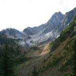
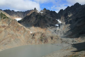
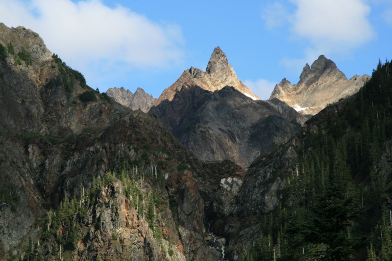
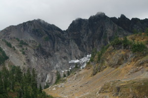
The trail tops out at 5247ft elevation on a large lateral moraine ridge, and cresting it is like picking door #1, 2, or 3 on Lets Make A Deal. Full of hope and anticipation as each step brings you closer to the top, the horizon of the ridge gradually recedes away like a curtain being pulled back to reveal…A huge disappointment…It appears the glacier has melted into a huge muddy puddle, like the last snowman of the season…Next to the highway, where the snow plow can efficiently coat everything in sandy, dirty snow…Like that.
The terminus of the glacier has retreated back father than the hairline on a balding middle- aged man, leaving nothing but bleak barrenness and a large muddy lake behind…
The glacier is nothing more than a small snowfield now, tucked back into a cleft in the middle of Mt. Anderson and the rock face here all the way to its pinnacles is bare rock in multicolored hues of black, grey and orange. At least the mountain has more character than many of its brethren in this range, they being more hulking, rounded masses with trees growing to the top. This mountain, at least, has more jagged and shattered features, leaving prominent precipices and parapets which gives it a more menacing look that the others. We walk the moraine ridge trying to look down into Enchanted Valley below, but all we can see are the tree covered folds of the mountains on either side coming together to block out any chance of looking down the valley. Taking a last look around we head back to our packs, a little disappointed…
Heading down the other side of Anderson Pass, here in the shaded areas, are small deposits of hail, remnants from yesterday’s storm, a reminder of how cold it got…
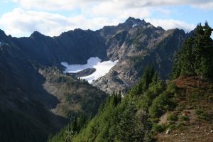
A few switchbacks down, and we can now look back up towards Mt. Anderson from the south side, getting a much better look at the lone pinnacle sticking up like an inverted snow cone. Sunlight pokes through the overhead clouds and spotlights the tips of the higher ridges, creating a worthy view. The waterfall that pours out of the dirty lake above cascades down over the dramatic cliff face like a spillway over a dam, and helps create the Quinault River, which runs down the length of the Enchanted Valley.
Speaking of which, one of the main reasons for planning this hike was because of what we could see from the chalet looking back up to the pass. Once could see a large snowfield or glacier that right now from here we still can’t see. Where is it? We look again at the map and surmise it’s around another ridge still. Another reminder of just how many miles one must put on to get to key highlights here.
A few more switchbacks through scrub brush and spring run-off chutes now dry, and we come to our cut-off for O’Neil Pass at 5.3 miles. The trail to here has so far been pretty good; smooth and mostly flat under the trees, and where exposed in the open along ridges or hillsides flat and in good shape. Now, large rocks form a steep staircase up along a wash here and the trail becomes noticeable narrower and rougher, as if to remind one that not many people venture here. Posted here at the trail junction is a paper flyer warning of a few close bear encounters and a reminder to practice proper bear etiquette like storing your food properly.
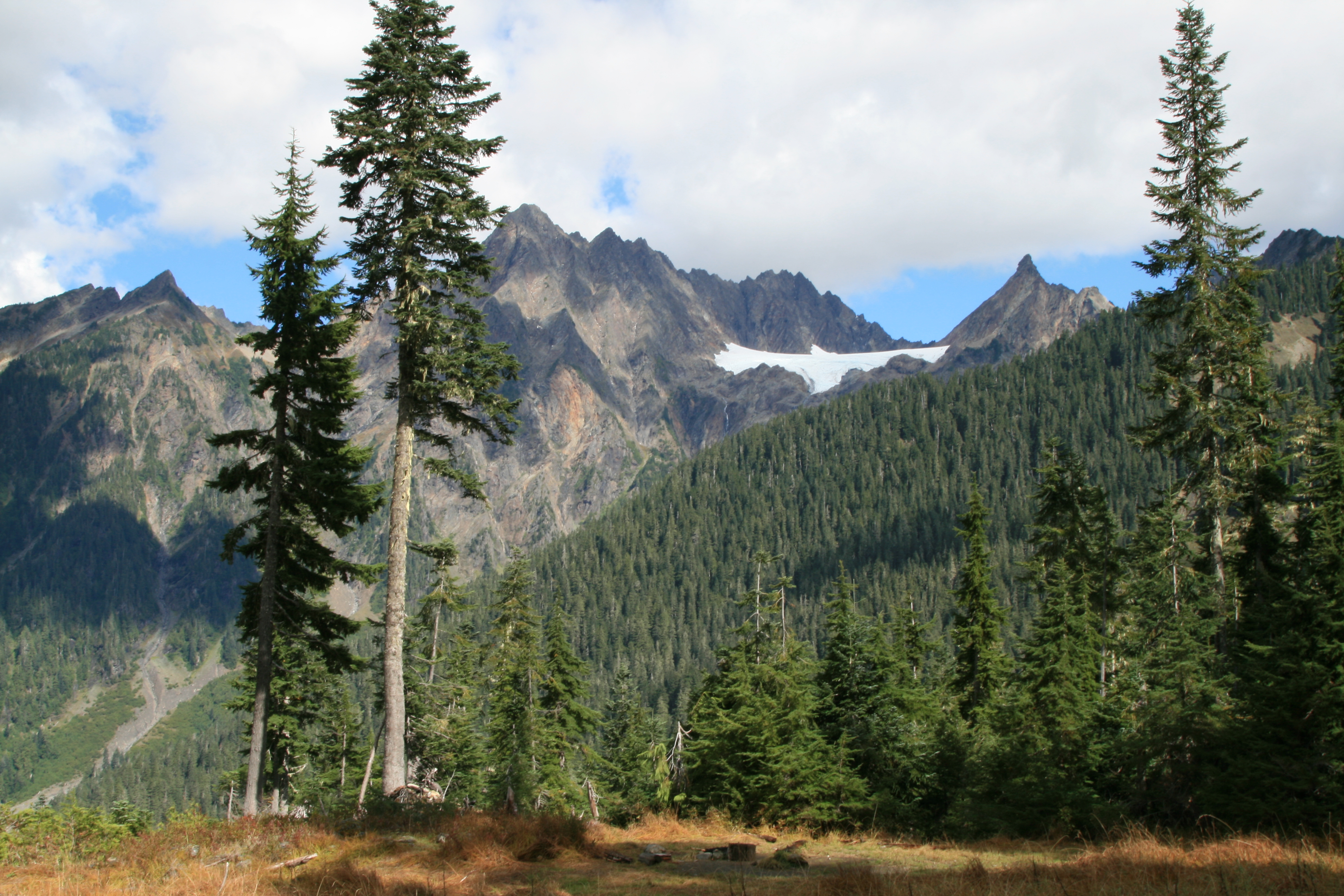
Up the trail goes, back into forest, switch backing until you reach a flat bench meadow, at the base of White Mountain, at 6 miles in. The small namesake stream is running down its flanks through the meadow. Now, looking back north, we can finally see the large snowfield that is visible from the Enchanted Valley spread between West Peak and Mt. Anderson like a large white dove in mid- flight. It appears to be flying below the clouds that scrape the tops of the higher peaks, making them invisible to us.
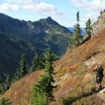
The trail follows White Creek up for a ways, crosses, then doubles back along the ridge, and just before we round the next fold of the mountain, we can look back down into the valley and see a couple coming into the meadows. The trail now skirts the side of the mountain, and then decides to go up, quickly, for several switchbacks for almost 2 miles of up until settling into a mostly flat jaunt hugging the side of the mountain. It moves into grassy meadows which gets you out of the tree line, and gives you good views across enchanted valley far below and over to the mountains on the other side. We can more or less approximate where the Chalet is below us, by the thin waterfalls falling down the cliff faces, good landmarks that we could see looking up from the valley floor a year ago.
Coming around one bend, almost walked into an older couple, “great day for a hike!” they say as we pass. Indeed, as the sun was just breaking through the clouds, lighting up the golden grasses growing on the slopes here. “Hope it holds!”, and then we’re moving on. And on. It goes on like this, up and down around one ridge and then another, into a group of trees, then back into the open into grasslands, for another 3.45 miles, which brings us to a grand total so far of around 11.5 miles, until we finally go around a large ridge and the trail doubles back on itself on the other side. Rounding this final ridge, the trail leads more uphill inside a large bowl to O’Neil Pass.
“…making the black rock of the mountain seem even more sinister, like steep walls on a black fortress…”
A cold wind is blowing up the valley into this bowl, chilling us as our clothes are damp with sweat. On top of the pass, at 12.5 miles, we can see dark clouds forming over Mt. Duckabush, making the black rock of the mountain seem even more sinister, like steep walls on a black fortress, all the surrounding hills are hues of grey, gold, reddish orange, and white, so the black of its rock stand out I stark contrast. You can see the remnants of its snowfields at the base. We take quick pictures, wanting to beat the ominous looking dark clouds that seem to be following us.
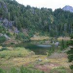
Heading downhill now from the pass is a nice break from the last 3 miles, which was mostly uphill, but the miles logged are starting to wear us down again. Just getting sore and tired from lugging heavy back packs this far. Shortly before getting to the lake, we enter a small, flat meadow, and see a small herd of Elk. I try in vain to get my camcorder out, but by the time I do the noise we’re making alerts them to our presence, and they scamper off. Finally, we’re on the final stretch, looking down into the lake basin. A welcome sight for weary feet. All thoughts of hiking another mile or so uphill to Lake LaCrosse vanish, so we go for the sure bet here at Marmot Lake. The camps are uphill by the bear wire, and we’re fortunate to be the first ones here, for about the only site we could find fit for 2 tents we take, a flat sandy spot between outcroppings of rock.
“Nope. The rhinestones just aren’t my style…”
No rest yet, though, as we’re concerned about beating the approaching clouds, so we win the argument with aching bodies that just want to stop, and scramble to put up wet gear and get ready for more rain. Then, Greg says, “hey, are these yours?” and shows me a pair of sunglasses that have been left behind by someone…“Nope. The rhinestones just aren’t my style…” Obviously a woman somewhere is sans sunglasses…That’s ok, since it doesn’t appear they’re gonna be required this weekend, anyway…
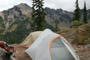
The tents just get set up, and it starts to sprinkle, at least the heavy rains have not come yet…This gives us time to kind of look around at where we’ve decided home will be for the night. Camp sits on a rounded knoll above the lakes SE shore, so one end of camp has a view down onto the lake, the other looks across the enchanted valley to Mount Steel and Mount Duckabush. The lake has a small rock island with a few trees which gives it a character all its own. On warm days, it looks as if you can wade through this shallow lake to get your own little island paradise, without having to go on a 3 hour cruise…
After taking trips down to the lake to get water and find out where the toilet is (priorities, right?), we’re ready for dinner. A side note here, the toilet is nice for this far back, it’s a solar toilet. Kind of surprised to see it back here, everywhere else has pit toilets…
The couple we had seen back in the meadows show up looking for a site, and we can feel their pain. Most of the sites here will only fit small tents, ours is the only site on this knoll that’s large enough really for 2 tents, so we tell them about the group site over by the toilet.
Dinner tonight is a new recipe, so we break out the Tortellini noodles with pesto sauce and roasted tomato and bacon bits. Turns out pretty good, a little prep involved, and you want to make sure you do the steps in order, otherwise you end up with a bunch of stuff that gets cooked, but then needs re-heating…Especially if you only have one stove and one pot…Maybe next time, we’ll bring two stoves.
“Now, I’m convinced we’ve met up with a special kind of crazy…”
Dinner safely stowed in starving bellies, we finish all our camp chores as dark approaches…And, so does a lone hiker…We were just creating our lounge chairs for the night, (backpacks leaned against the rock wall with seat cushions for our aching butts), when he walks up onto the rock slab were propping our lazy backsides up against, and says, “Hi, guys, I made it!” raising both fists into the sky in his best Rocky impersonation…Then, a hurriedly added remark, “this is Marmot Lake, right?” A little stunned by the introduction, I reply, “Yeah, this is Marmot Lake. You made it…” thinking to myself, “Has this guy confused us with someone else, or is he just confused??” He goes on to explain that he has just gotten here from the Graves Creek trailhead, hiked all the way up the Enchanted Valley to here, in his estimation about 27 miles! Now, I’m convinced we’ve met up with a special kind of crazy. Makes our 14 mile day seem pretty weak in comparison…
We’re constantly surprised by the amount of people we’re seeing back this far. WE really thought we’d be the only souls around, and here we’ve already seen a handful of people, even if one seems to be a lot more determined than the rest of us…
He was still futzing with his tent and headlamp when we settled in for the night, and noticed in the western horizon a strange orange glow which continued to grow brighter as the night got darker, and we would see an occasional bright light flicker down in the glow. It didn’t stay long, there for about 30 seconds, and then wink out but the orange glow persists. We were stumped trying to figure out what in the world was creating that light…Once I was home, I was even more puzzled, as the largest town in that direction, just south of Mt. Olympus is La Push on the coast, and I’m not thinking it was that far away. It looked like it was kind of lighting up the valley on the other side of Mt. Christy, at least from our vantage point…Strange and stranger…
By 9:30, we’re done, time for bed, and we crawl into relatively dry tents, the rain for now seems to have given us a break. That is, until around 11, then it starts raining. Lightly at first, then heavier and heavier until it becomes a downpour. The only thing we hear for the next 7 hours is rain thrumming on the rainfly, which makes sleeping nearly impossible. It seems that over the course of this 7 hour deluge, I saw every hour pass on my wrist watch…
Thank you! And, I suppose a thank you to borvest inkral is in order, too? Is this a community forum as well? I notice there are different e-mails attached to it…Anyway, as far as community forums, no, i’m not aware of any, I know that I had some difficulty sometimes getting information on different hikes that I was interested in, so I decided to create a site that listed the places that I had been to, and what I thought about the conditions, views, etc…Again, thanks so much for the nice reply!!