Day 2
13.92 miles, 4966ft gain/loss..Fitbit Steps: 39,282 Well, those miles are the “unofficial” miles we put in for the day, but the actual trail miles that will show up on the “official” trail data for GPS, will be considerably shorter…Why, you ask? Well, because of the wrong turns we took to get back to the lake and our campsite…Not all were my fault, as one of the trail junctions didn’t show up on the GPS pre-planned route using TOPO maps as reference, and the other was just trying to find a good way to descend down to the Copper Pass trail….A large portion of the day today would be off-trail trekking…
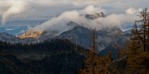
But, the storm from last night having passed, left us with glorious sunshine to start our day with, a welcome sight after last night. “Hey, did anyone remember to bring sunscreen?” Nope…Not a one of us planned for all day sun, that’s for sure…
After breakfast and a few photos around the lake without the dark skies, and we were ready for a day trip around Stiletto Peak. The plan was to go off trail over to Copper Pass, down, follow the trail along Copper Creek to close to the junction with Bridge Creek, then hit the Stiletto spur trail, which runs parallel with the PCT, then head up another trail that leads to Stiletto Peak, and more off trail back to the lake. Sounds good, right? Well, in practice it was far different, but more on that later…
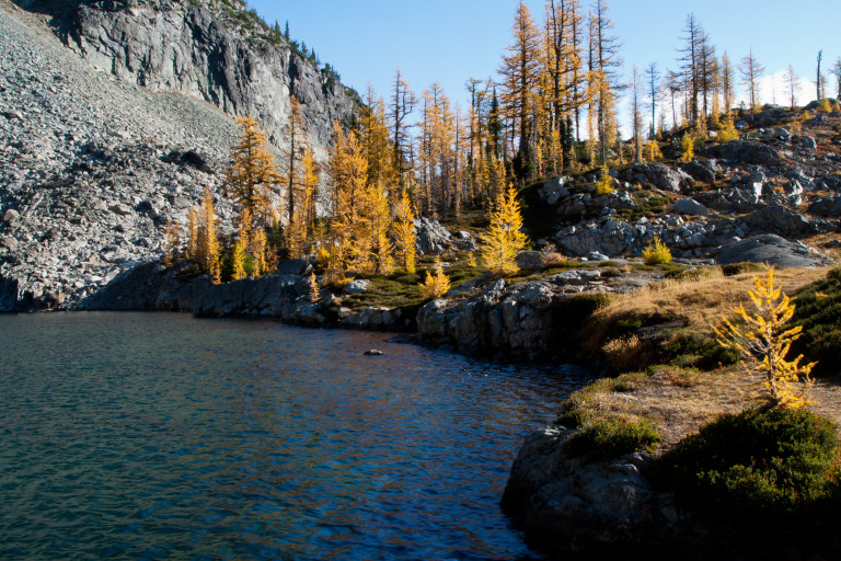
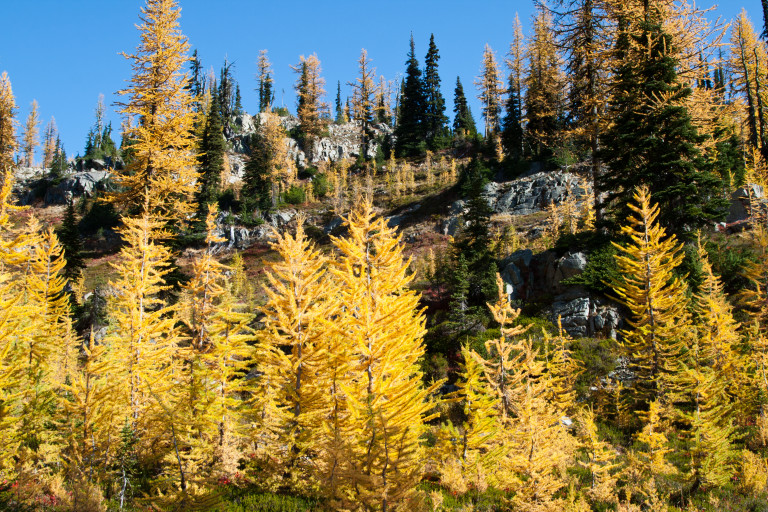
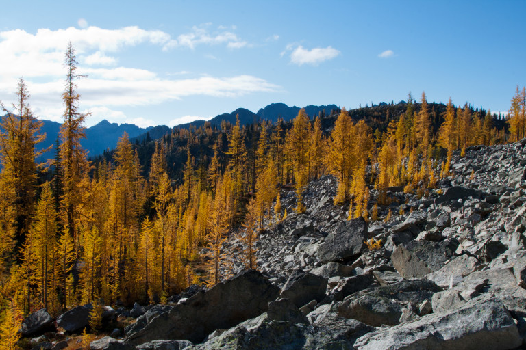
We head east directly from camp, and around the leading ridge coming down from the unnamed peak that streaks skyward on the northern shore of the lake, and are greeted by a whole valley full of bright golden larch. This valley leads slightly uphill following the eastern side ridge of the peak and this ridge runs all the way up to Copper Pass. A huge talus field lays jumbled at the base of the peak, running out into the valley below, and we have to cross a bit of it to reach the valley floor, where the larch grow in abundance, this is only about a half mile from the lake. Once here, we spend a lot of time marveling at and taking pictures of the lit up larch, as the morning sun is hitting them full on, and they seem to glow like Las Vegas strip neon…The valley floor is covered in now golden grasses, and there are large patches of crimson huckleberry brush…It’s hard to travel more than about 100 yards or so before wanting to stop and take more pictures, it is a beautiful scene, like a carefully sculpted garden.

Once past the small valley of larch, we continue upwards steeply through open grass covered terrain, looking for a viable way to Copper Pass. Since there is no trail, it’s make your own across open meadows, stair stepped from one to the other, until we come to decision point. Continue upward, or drop down some and follow my pre-planned route I drew at home looking at TOPO maps for the GPS…Well, being in an adventurous mood, we decide to continue upwards, and come to an impasse at a steep cliff, at 1.41 miles.
The advantage from this point, however, is that we can look down onto Copper Pass, and see the trail. Of course, now we must backtrack to a position where we can continue forward, around this ridgeline. So, we head back to a lower shelf where we can get around this roadblock, and as we round a ridge on track with where I pre-drew the route at home, there is a steep section here that hugs the ridge and comes to some large flat boulders that create a natural ledge, which provides an easy way down into the next step meadow. Now, if we had just followed my pre-planned route from camp, this might be only about a mile from the start, but…If following our walk about, it was closer to two miles, an accumulation of elevation and mileage that will add to our trip time…
“I’m sure I was the last thing she expected to see off trail this morning…”

Just as I round this ledge, and look down, I’m looking down at 3 women coming up from the other side. “Yep!” I say, “This would be the best way up here!”, completely startling the woman below. I’m sure I was the last thing she expected to see off trail this morning…We waited for them to climb up before we headed down. Now, across the small meadow, and if we had only stayed a little higher through this huckleberry brush covered slope, we would have cut off some more time, but instead opted to drop in lower, reaching the trail quicker. So, finally, we’re on the trail at 2.62 miles, and, of course, if we had only stayed on track, probably would have been closer to 1.3 miles…As you can see, the “wandering” that we did quickly started adding mileage…
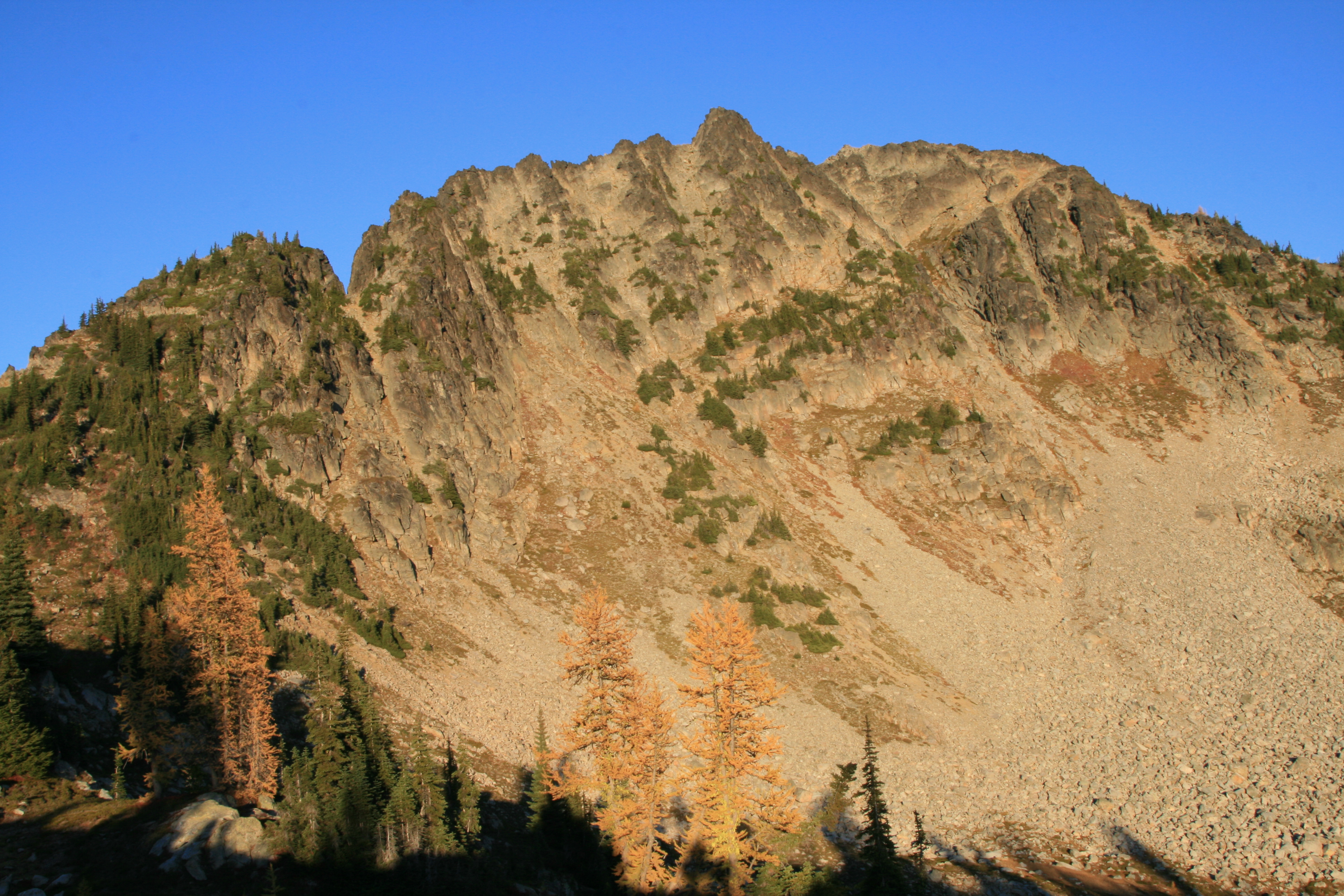
No matter, finally on a trail, we quickly make it up to Copper Pass, straddling the ridge at 2.87 miles, and 6695ft elevation. A true pass, you can see off to the south and north from here, and south, back the direction we came is much more scenic…The larch cover bald rock and you can see the scree and talus field we came down off of to reach here, with distant peaks rising as backdrop off on the horizon…The peaks on the north side of the pass are much closer, but bald and devoid of much character, except for the needles of some unnamed ridge beyond the one directly in front of us…
We head down into the valley below us, and before long run into a large group of eight hikers coming up to Copper Pass. After stopping to chat, we continue along this easy to follow, but not well maintained trail that skirts the bottom edge of this ridge. The featureless slopes rise steeply to the top of the ridge, and are mostly open, colored with the scarlet hues of huckleberry brush where it grows uphill into the scree fields. As the trail rounds the bowl, it comes close to a small, unnamed tarn at mile 3.26 miles. We journey slightly off trail to a small bench above it to try and get a better look and some pictures, but…I think to really see what its’ all about, you would have to venture down there, and we decide to keep on the trail.
The trail stays at about the middle of this ridge, side-hilling all the way through mostly steep grassy open areas, looking down into the Copper Creek drainage, and stays like this all the way to a trail junction at appx. 5.1 miles with a kerchief held down with a rock…Well, of course we stopped, looked at the GPS unit, and I thought, “Well, this is a long way off from where our trail is supposed to go down…” Not to mention, the TOPO maps that I had pre-planned my routes on showed only one trail heading down to Bridge Creek, and this was clearly a junction…What to do? Well, since the maps I had only showed one trail leading to the junction, and not two, I decided that we should follow the trail that continued on to what I was sure was to be our destination…Where it showed the trail heading downhill was still a mile away!
“…I couldn’t believe it…How could the maps be so wrong?”

Well, we hiked that mile to where the trail should have headed down, and yep…No trail…It just kept heading west…So, we kept heading west, waiting for it to head downhill, and it never did…All we managed to do was trace a route all the way to highway 20!!! I couldn’t believe it…How could the maps be so wrong? We had seen this before, where trail junctions weren’t where they showed on the map, but never one this far off. Not to mention, a spur trail that led to the highway, with no turn out off the highway for it, etc…I was a little upset. We already had a long day ahead of us, and after coming downhill this far to nothing, now we had to retrace our steps back to where the TOPO maps showed the trail heading down to the creek drainage far below us, and off trail we went again, at mile 6.08 from the lake…That’s not counting the 1.46 mile round trip we took to the road!!! Again, more accumulated mileage on a trip that was already going to be long….
Straight down the steep hillside we went, beating brush through the trees, and thankfully, most of the downhill to begin with was mostly covered in grass. And, as we hit the tree line closer down by the creek, we ran across the trail. Whew! That was a relief, although, now after seeing how far off the trails were on the map, I began to wonder if we would even see the cut-off for Stiletto Peak. My fears were unfounded, though, as we eventually ran into the Stiletto Peak spur trail, and made haste towards the trail that would lead straight up to the peak…
And, wouldn’t you know it? The spur trail was nowhere near where the map showed it would be…At least, this time, it was in our favor, for we reached it within a mile of turning left onto the spur trail...This time, there was a clearly marked sign, proclaiming the way to Stiletto Peak was this way…We reached that at 9.18 miles…Now, it’s all uphill mostly in the trees, and switchbacks endlessly upwards. Along the way, we ran into the 3 women we had startled earlier in the day heading down…”Hey, haven’t we seen you before?” Yep, that was us, only now a little more worn and wet from sweat…
“We ended up eating and cooking by headlamp…”
Over the next 3.3 miles, we would switchback endlessly upwards 2895 feet of elevation…Steep in anyone’s book…Brian said he counted 38…When we finally got into the meadows up on top of the ridge that sits below Stiletto Peak, we again ventured cross-country, making our own way to the lake. We were beat, and arrived in camp just as the sun went down, around 6pm, and we quickly set to getting water for dinner. We ended up eating and cooking by headlamp…At least, we weren’t fighting the rain and wind, and tonight, we set around enjoying the brilliant stars and Milky Way that shone down from above, before turning in for the night…A long day, and lots of country traversed, but when I got home to look at the pictures, I think I could say that it was a successful day…
I’m truly enjoying the design and layout of your website.
It’s a very easy on the eyes which makes it much more
enjoyable for me to come here and visit more often. Did you hire out a designer to create your theme?
Fantastic work!
Hello, and thanks! Yes, I had to hire a designer, too much for me to get started, thats for sure…I still have a lot of trips, videos, reviews, etc. to add, been a little overwhelmed with how long it all takes, but getting there!
I used Upwork.com to hire a freelancer.
Again, I am humbled by your kind words!!
What’s up, I would like to subscribe for this website to obtain latest updates, so where can i do it
please help.
Thank you so much! I just recently updated my site, and this is definitely one of the things I have yet to add…Been a little behind in doing all of the uploading of content, etc. Hopefully, I will get this done soon. Right now, in the planning stages for hikes this year.
Again, thank you! Hopefully, you will continue to check back in as I add new articles!
Thanks, great article.
Thank you, appreciate that!
Thanks! Had to have a developer do the heavy lifting for me, but I’m currently adding new content as soon as I can, still have quite a bit of content to add…
Thank you, glad you liked it!
Ahaa, its pleasant discussion concerning this piece of writing here at this blog, I have read all that, so now me also commenting
here.
Thanks for the kind words!
Yoou need to be a part of a contest for one of the greatest blogs on the internet.
I’m going to recommend this blog!
Wow, thank you for the incredible praise! I am honored, and humbled…Thank you so much! Happy to see that there are people out there reading!!!
Thank you! It’s nice to know that there are people out there actually reading! I hope you do return!
Good day! Would you mind if I share your blog with my zynga group?
There’s a lot of folks that I think would really appreciate your content.
Please let me know. Thanks
Hello! I would reply to you by your name, but unfortunately, I do not read Russian…I would be honored if you share this with your zynga group! Glad you like the site! Going on new trips this year, so there will be new content then, and I hope to include gear reviews, and videos soon! Again, thanks for your interest!
Thank you for your interest! What more would you be interested in? Info on where this is located, etc?
Have you ever thought about including a little bit more than just your articles?
I mean, what you say is fundamental and all. But imagine
if you added some great graphics or videos to give your posts more, “pop”!
Your content is excellent but with pics and video clips, this blog could certainly be one of the best in its field.
Very good blog!
Yes, I have! Just recently added a video to the Goat Rocks Traverse, hope to add more soon, as well as a page of short videos of some of the hikes that I thought were most excellent! Also, hope to add some product reviews of some gear that we use that we think others would benefit from, and some gear that didn’t quite meet expectations…Again, thanks for the nice review!
Thank you so much! Appreciate that, glad to see that someone is actually reading! Will be adding more treks this month, every weekend, trying to get out and get more trips in! And, again, thanks so much!!!
Thank you, glad you like it! Just added a new hike, the Goat Rocks, have a couple more planned so there will be a few more this year, as long as the fires here don’t shut everything down…