Ranking: 2/5 We suffered so you don’t have to…Probably really only deserves a 1 of 5, but, it was a nice lake with one good campsite on the north shore. Hard to follow trails at times, with just so-so terrain features to look at . You would definitely be better suited on going around on the Golden Lakes loop, and if this lake was something you just had to see, well…Then it’s only about a 2 mile jaunt down into Merchants Basin from Switchback peak…Again, not sure I could recommend unless you’re into that whole sadistic bash your brains in cause it feels good kind of thing…
Difficulty:8/10 . This is a hard hike. Hard to get to, hard to walk through, and hard to follow at times because the trials are so faint. Did I say trials? Yep…Really believe that if people don’t start using it more often, in about 10 years, this hike will just be a distant memory, and who could blame them? Too much effort expended here to recommend.
Getting there: NOTE: If you Google how to get here, be warned…As of this writing, the Black Canyon Rd. was washed out, so this is an alternate route that works. From Wenatchee, head north on US-2/97-S for 11.8 miles, then continue to stay on US 97N, and drive 40.3 miles to WA-153, and turn left just before crossing the bridge into Pateros. Follow WA-153 for 16.8 miles, then turn left onto Gold Creek Loop Rd. Go another .8 miles, and turn left onto Gold Creek Rd, and then go another 1 mile and turn left to stay on S. Fork Gold Creek Rd/NF-4330. Will be gravel one lane in poor shape for rest of the way. High Clearance vehicle/4WD advised, cars will not make this trip as of this writing!!! Deep washouts. Now, drive 13.4 miles on NF-4330, and turn right onto Grade Creek Rd/ NF-8200 and follow road 8.4 miles. Will see TH and small parking lot on left. Trail is across the road.
Maps: Green Trails #115, or custom correct MyTOPO.
Permits: No permits required, possible Northwest Forest Pass or equivalent to park at trailhead.
Sunset Lake Loop Added 9-13-2017
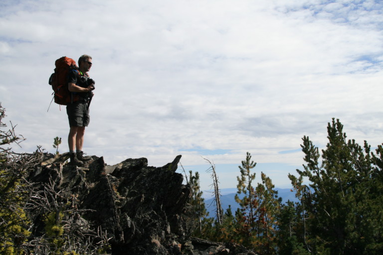
You know how the best laid plans can go awry? Well, these plans almost went the way of the Dodo bird…It all started out innocently enough. Drive to the Methow Valley, about a 5.5 hour drive to the TH at Summer Meadow. Sounds like a pleasant place, right? Summer meadow brings to mind sunshine with flowers, maybe even running barefoot through daisies with your picnic basket, right? I mean, what could go wrong??? Stay tuned…
“…that at first we thought was a runaway locomotive parting the trees like so much grass…”
After turning off the Methow Valley highway, we were supposed to follow Black Canyon Creek road before turning onto Cooper Mt. Road, then the Grade Creek Rd to finish it out.So, we turn onto Black Canyon Rd, and in minutes, it becomes a one lane road. In one particularly narrow section, as we’re travelling through encroaching alders on both sides of the road, we get a nice surprise. Crashing out of the close in alders on the passenger side of the truck, we see a large dark shape that at first we thought was a runaway locomotive parting the trees like so much grass. We both holler, as a large moose comes blasting out of the trees. But, before she slams into the side of the truck, she quickly puts on the brakes, does an abrupt spin move that would make any 350 lb lineman burst with pride, and tramples trees and anything else in her way to get back to the small pond she had just came from. Water was sent spraying in all directions as she splashed down, doing her best to part ways with us…Not sure who was more surprised, her or us at the moment…First time I’d ever had an up close and personal with a moose, glad I was in the truck for it!
Hearts still pounding, we continued on up the road and came to a road closed sign…What?! I didn’t see anything about that on the web…How had I missed this? There was a road to the right, which we were hoping against all hope that might be a detour, but…After about a mile, it too, came to a screeching halt…Dead end…Since I remembered that the Gold Creek Rd also connected to the Grade Creek Rd somewhere further north on the Valley highway, we headed back out, onto the highway, turned left, and continued on to the Gold Creek road, and as we did, Google planned a new route. Do we trust that these roads still exist, or are also not blocked??? Nothing but time to lose, we follow the instructions, and the roads get us there, but not without issue…It seems in places the road is little more than a jeep trail. Deeply rutted from run-off in many places, it makes for some slow going. Definitely only want to attempt this road with 4 wheel drive, high clearance vehicles…After enduring this rocky, bumpy, rutted out road for 2 hours, we reach the Summer Blossom trailhead, and I see no summer blossoms anywhere. All I see is dust, and trees….And, there is one car here. Really? After this ride, I would have expected none…It’s now 1:40pm, pretty late time to start, but we were not to be deterred…
Day 1
6.3 miles, 2613ft gain/1800ft loss. Fitbit data: 26,044 steps, 477 floors.
Right from the beginning, the trail heads up. Steadily, through mostly fir, the trail is narrow, but easy enough to follow under the protection of the trees. Mostly dirt here, with occasional rocks jutting up in the way, making sure you’re paying attention…It goes like this for about 40 minutes, then it begins to break out into the open as the trees begin to thin. Now, you’re walking along open ridge, where brown grass mostly covers the steep hillsides, with occasional fir and pines growing sporadically along the ridge line.
As we pass some of the small clusters of trees, without warning, “Flap-flap-flap-flap!!!” We scare several grouse out of the trees along the trail. I say scare, but I’m pretty sure at that moment no one is more scared than my heart, which does it’s best to exit stage left. We “scare up” several grouse along this portion of trail through the day, always with the same result…Flap, flap, flap, then us both jumping, cursing, and then for a short time, we spend most of the time looking into the trees and brush along the way, trying to spy out these heart-stopping moments before they happen…But, you know how it is along a trail that there’s really not much to look at, you’re just trying to get to your destination, so it’s mostly just trudging along with your head down, lost in your own thoughts, cause who has the breath for conversation , right???So, when a grouse rousts out of a tree or bush right next to you, its loud and unexpected, so it gives the ol’ heart a shot of adrenaline…Little jerks….
“…which sounds like broken dinner plates being disturbed…”
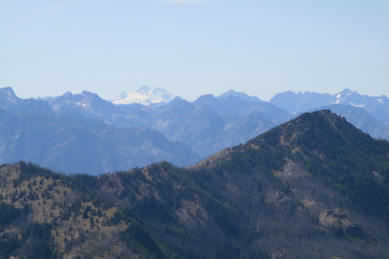
Speaking of the trail…It’s narrow, rocky in most places now and very lightly used. You can still see it well enough, but it still seems to us that if it isn’t used more often, it may disappear over the course of the next 10 years. As we approach the pass between the two Navarre Peaks, the trail gets rockier as it nears the top, mostly loose shale, which sounds like broken dinner plates being disturbed as you walk over them. Finally, at mile 2.2 and 7851ft elevation, we reach the top and can see the other side. In the distance, we can see snow covered peaks of Glacier Peak across invisible Lake Chelan, hidden from view from the multiple folds in the earth between us and it. The haze from forest fires makes it difficult to get good pictures of them, even though I try anyway…Digital is cheap.
“…This place might be well named as “Plains of the Forgotten”…”
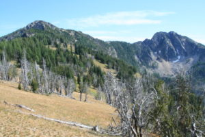
Dropping down the backside of the North Navarre Peak, after a short stint through more trees, you’ll enter rolling grassy meadows, a sight we’re not used to seeing. Dead, skeleton trees dot the landscape here and there, adding to the impression that the area is abandoned, not so rosy a mental picture as Summer Blossom. This place might be well named as “plains of the forgotten”, or something equally foreboding…OK, not like cling to moms apron strings scary or anything like that, but definitely, this place seems like a place not only rarely visited, but like it had seen better days, giving it an eerie, dead feeling…I expect to see vultures roosting in the bare branches…You can see the surrounding hillsides, mostly covered in trees, except for the rocky points that make up the uppermost peaks, like the Navarres. Otherwise, it’s just more rounded hills with grass that’s now brown, and a smattering of wildflowers, wherever there might be water, which, up here, there isn’t any running along the surface.
“…at mile 5.4 that indicates where a trail used to be. Yep. Used to be…”
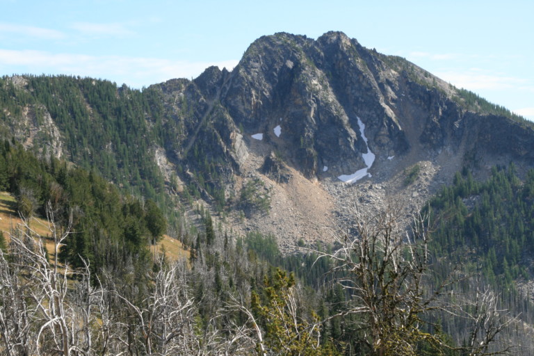
Coming downhill at mile 4.97, we drop down into a small basin at the base of rocky ridge tops that have been shedding rocks for eternity, and the beginnings of a small stream coming out of the rock littered base, which keeps this little valley green. In fact, the trail almost disappears in the meadow, now completely over grown in grass. Where a few have gone before us, tromping down the vegetation, provide the only clues that a trail ran through. Back up the ridge on the other side, then around to another fold in the same rocky ridge and we come to the spot on the map at mile 5.4 that indicates where a trail used to be. Yep. Used to be, as we can no longer find the junction or even a faint remnant of trail leading uphill. And, it’s straight up through scrubby pine and fir with clumps of grass clinging to the rocky, sandy soil. Straight up for a quarter mile, and 368ft of elevation, to be sure
It’s about 4:30pm, so we decide that we need to go up and over, otherwise, if we continue on the loop around and over switchback peak like the original plan, it’ll be too late by the time we get there to make camp. As we head straight up, we see occasional glimpses of the trail here and there, just small sections faintly heading the same way we’re headed…After reaching the top of the ridge, we stop, catch our breath, and stare down into the Sunrise Lake Basin, and Its quite a ways below us…Over what looks like large rock outcroppings near the base of this steep bowl. A line of trees runs up from the bottom, on the lakes western shore, probably where the old trail used to be, but after wandering down along them, what faint trail there might have been vanishes into the rocks, and it looks as if we’ll be fighting our way through trees, so instead we opt for bailing out straight downhill.
“…A couple of times, we did the Slick Rock Shuffle…”
We pick a line that looks less terrible than others, and pick our way carefully down to the lakes edge, over loose rock, sand and boulders. A couple of times, we did the slick rock shuffle, dislodging large chunks of rock or material, doing our best not to get carried away with them. An occasional boulder would cut loose and quickly gain speed, tumbling downhill, clacking and clunking as it bounced off its brethren, a good reminder for us to keep ourselves properly gapped as we traversed the rocky slope. A sigh of relief later, and we’re on the bottom, and we make our way over to the northern end of the lake where a good campsite awaits, complete with logs for benches, and a nice back rest around a very sturdy campfire ring. Obviously this place has been visited often, just not by our route i
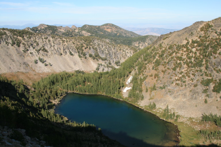
Lots of large larch trees here along the water’s edge, and where the outlet stream cuts a swath, nothing but bright green grasses and flowers line the banks. A stark contrast to the grassy areas that aren’t getting a constant source of water. This lake is large, and sits in a completely enclosed bowl except for the northern end, which is open. Reminds you of a small volcano with this side blown out, kinda like Mt. St. Helens. When we were walking along the shore, we saw two dead fish floating belly up along the edge. One was about 16 inches long, a nice sized fish for an alpine lake, obviously, someone had been here recently and caught them, so there are fish here to be caught. The lake water is blue and clear, and you can see the bottom of the lake out to where it rapidly drops off into solid blue and deep waters.
After dropping off our packs, we sit for a few minutes, relishing the idea of being done doing our best mule train impression before setting up camp. Grunting, we get up and quickly get camp set up, as its 5:30 and the sun is already starting to go down behind the ridge line.
“…and just a few skeeters that quickly fall prey to Greg’s Exterminator, makes for a pleasant night…”

Dinner is Chicken Marsala, but this time, I remember to bring some bowtie pasta. I must say, this is a recipe that bears repeating…Easy cleanup, and it’s time to relax with a little nip. A slight breeze, and just a few skeeters that quickly fall prey to Greg’s Exterminator, makes for a pleasant night. Before heading off to bed, one thing we find peculiar. It’s dead quiet, almost eerily so. No wind rustling through the trees, no crickets or frogs, or birds. Just nothingness. We would have thought the entire area had been vacated of wildlife, except we did see a couple squirrels that chattered at us as we first arrived. And, a mouse that decided it was unwise to try and get into my pack after it saw me coming after it on a tear. That was it. Nothing else, very strange. So, off to bed, and it was just like sleeping in a soundproof booth. We both remarked the next morning how strange that was, I believe that was the quietest night I have ever spent in the backcountry…