Ranking: 4.5/5 Wow…This came as close to a perfect hike as perfect gets. Many people worry that because this is a “Multi-use” trail, open to motorcycles, horse, and mountain bikes that it will be noisy and overrun, but, the few bikes we met along the trail never caused a problem, and they’re over the trails in short order, leaving the good campsites to you. It felt, for the most part, as if we had to place to ourselves, never running into another camper the whole trip. Beautiful alpine lakes, surrounded by walls of jagged granite, highlighted by golden larch, provide incredible high mountain scenery, miles and miles of trails wander through open meadows, dotted with larch and distant views of snow covered peaks make this a true eye candy loop hike that should be on your short list of things to do!
Difficulty: 5/10 Yep. A 5! The days are relatively short, mileage wise between camps, and the trail grade is barely a medium difficulty making for quick, bomber hiking, the only steep section is going over the Angel Staircase to reach the shoulder/pass of aptly named Switchback Peak, and then the steep descent into Cooney Lake. Other than that, the trails are in excellent condition, easy to follow, and there are plenty of campsites at the lakes. The only caveat to that, is that in some instances, the TOPO map, and Green Trails Maps don’t accurately reflect some of the trail junctions, (where they are at), and the signs on the trail give names that don’t appear on the maps, either. Of particular note, is the X intersection below Boiling Lake. When you reach this junction, pay close attention, and be sure you head left along the signed “Summit Trail” that crosses Prince Creek. The TOPO map, in my estimation, does a poor job of indicating where these trails actually meet.
Getting there:From Wenatchee, drive 97N to highway 153N, turn left and go 16.8 miles to Gold Creek Loop Rd, turn left, go .8 miles to Gold Creek Rd, turn left, go 5 miles to NF-4340, start gravel road. stay right for 1.6 miles.(left goes to Foggy Creek CG). Turn left onto NF-300 to end, 4.3 miles.
Permits: Northwest Forest Pass or equivalent required to park at trailhead, sign in at trailhead
Maps:Green Trails #115, Prince Creek. Note: Be aware, that current maps do not accurately reflect what the signage on the trails indicates, especially when hitting the intersection with the Summit Trail below Boiling Lake.
Golden Lakes Loop Added 11-9-2012
Looks as if we’re going to get extremely lucky this year, and have a season of NO RAIN for our trips!!! That and a minimum of bugs!!! I’ve never seen a season of backpacking that has been so devoid of the pesky things, and we’re overjoyed at this turn of events…We’re heading to the Okanogan for another 3 day in the Sawtooth Mountains, and it looks as if it’s going to be a nice and sunny weekend. The only concern is going to be the smoke from all the fires east of the Cascades, for it seems as if the whole east side is burning up from our dry summer. In fact, the week before, these trail heads were closed due to a fire in the Gold Creek area, so we feel extremely fortunate for this hike to have happened at all…
Leaving town around 4:00am, we make the long drive over Snoqualmie Pass, through Cle Elum, and then over Blewitt Pass to Wenatchee. As we made the top of the pass, and headed down, the smoke was so thick that visibility was down to maybe 100 feet or so, and the rare car we passed on the highway, started out as two orange orbs, the headlights looked like marker lights from the dense smoke. Very strange. It was a choking smoke, too, and we were happy to get on the other side of Wenatchee, where the smoke started to thin. Feel very sorry for those trapped in that, it can’t be healthy to be breathing that stuff…
Day 1
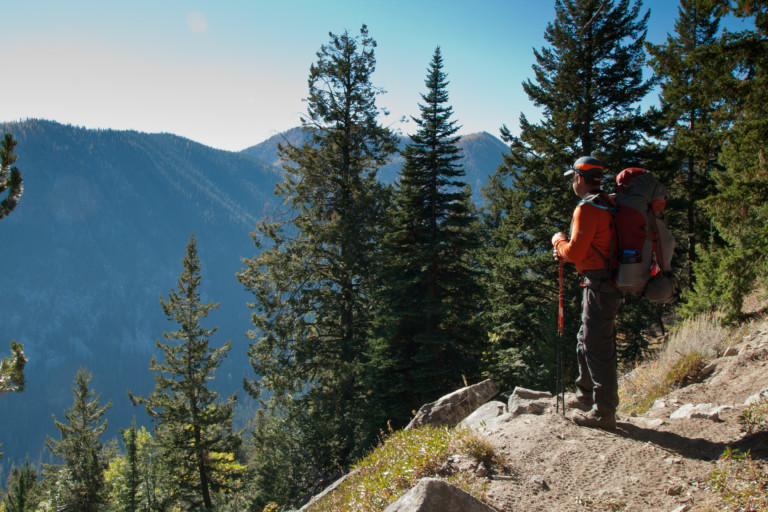
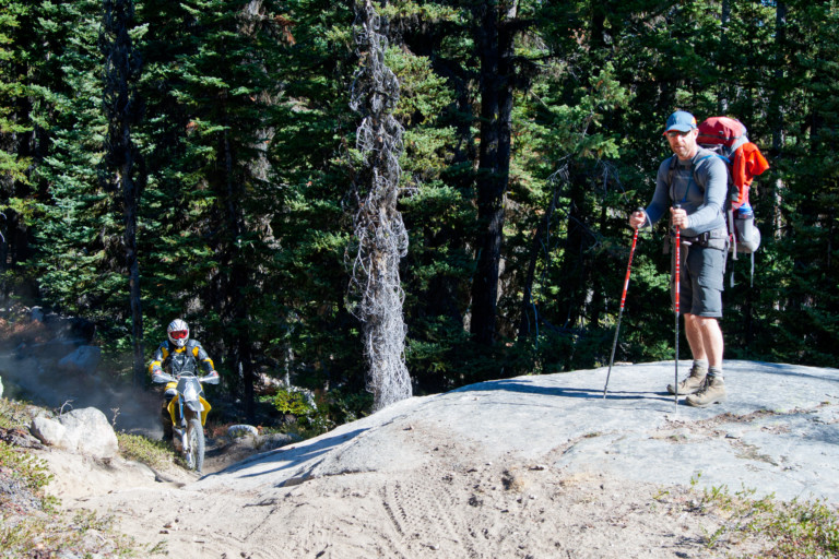
6.1 miles, 2867ft gain/500ft loss. Finally at the trailhead, 242 miles later, we’re breathing clean, cool air at the trailhead for Crater Creek, which is also the beginning for our Golden Lakes Loop. There are several campsites here in a small campground, and only one other car at the trail head parking lot. There’s a nice single seat toilet here at the campground, one of the nice concrete shelter ones, with a locking door. It was nice and clean when I used it…The only people at the campground, was a large group of motor bikes. So, having said that, I think it’s important to point out that this loop hike is a multi-use trail, open to stock, motor cycles, mountain bikes, and of course, backpackers. In the entire 3 day journey, we never saw another backpacker, (until the end), but we did see about 12 motorbikes, and over 20 mountain bikers. And, it was never an issue. The motor cycles were courteous, as where the mountain bikers and several of them stopped to talk. As soon as they were around the bend of the trail ahead, we never heard them again, so it wasn’t as if it was loud and obnoxious, most of them were trail bikes, most around a 125cc, biggest we saw was a 400, maybe, and they weren’t out there tearing it up, so…The reason I say this, is because I don’t want to scare off other fellow backpackers, by all means, don’t let this stop you, as it was never an issue, at least for us…

Because of the lack of rain for weeks, the trail is dusty, but not obnoxiously so, for the soft, wide tread path makes for soft foot falls, cushioning every step. The way begins with an easy, constant uphill, and will continue this way for the rest of the day. The smell of pine is in the air at the start, and it quickly disappears into a dry, scrub style forest, some trees here are a deciduous variety I’ve never seen, their leaves already turning gold as fall approaches. Instead of bare ground under the sparse tree cover, everywhere appears covered in grass, so some of the hillsides look like steep meadows, a nice change from the constant brush that covers any bare ground on the west side of the mountains.
The first turn-off, at .73 miles, heads left, away from the Crater Creek trail. As we head up the trail, you can see across the Martin creek drainage to a couple ridgelines covered in trees, whenever there’s a small clearing. So, for the most part, it’s just head down, and continue up the trail, as there’s not much of interest to see for now…Right at a mile in, we round a ridgeline, and this ridge we will follow all the way to Upper Eagle lake. After a couple big, lazy switchbacks, and trees that continue to get larger in circumference and height, we finally see some flecks of gold mixed in with the firs, on the ridgeline opposite us, ridges that lead up to the Sawtooth Mountain range, our destination for the day. Too far away to really take good pictures, it’s still an encouraging sight to see that the larches have turned. The weather is perfect for hiking, and we’re making good time without sweating, sunny, and maybe around 60 degrees, it’s all we can hope for.
” …the uphill trudging is actually pretty easy…”
Now, at 2.27 miles, we come to our right turn, onto the Golden Lakes loop. To the left, is the Martin Creek trail, our return leg on the last day. Firmly in old growth timber now, it’s just a march through the forest, not much to look at except for trees and the dusty path ahead of us. Near the beginning of the trail we were passed by a group of 6 motor bikes, and an hour or so later, another small group of 3 or 4, but since then, we’ve seen no one. The trail is still in great condition, wide, with a nice flat tread path, so you never feel as if you’re walking on the side of a hill, it’s always well cut into the side of the ridge, and mostly dirt, so the uphill trudging is actually pretty easy. We continue this pace until we reach a signpost that states, “Not maintained trail” which leads off to our left. Just past this trail, we can see the way ahead growing rockier, and with fewer trees. The grass still covers the slopes, and it’s clear that the terrain is changing.
“…with large talus fields piled up at their bases, as if they had been sawing at the sky…”
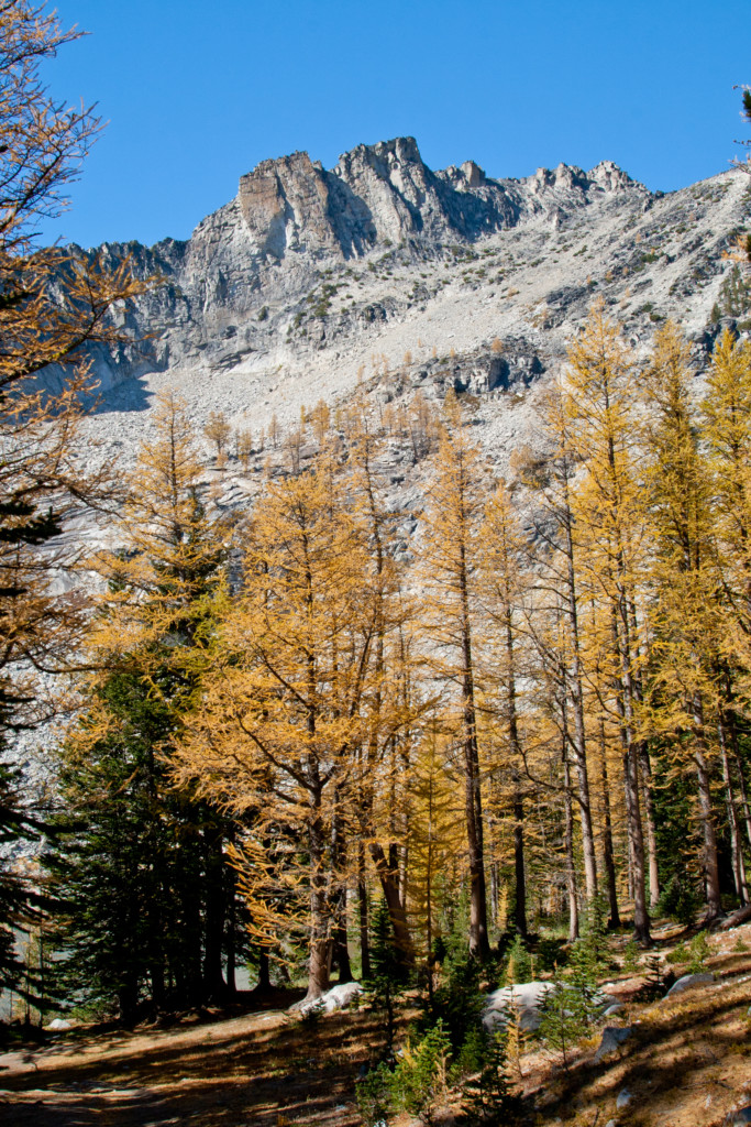
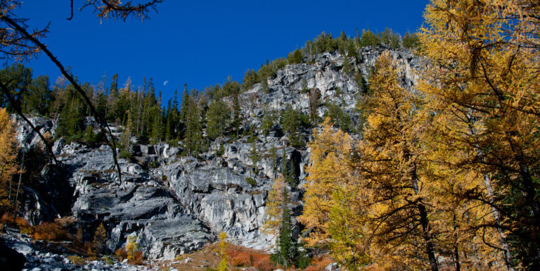
As we break out into the open, it’s an amazing transformation. Large, white boulders poke out above the ground, surrounded in the fields of grass, an occasional clump of alpine firs dot the hilly landscape. Now, we can clearly see across the valley below, to ridge tops that are dotted with larch, like massive candle flames lit among the firs, for the rays of the sun seem to light them up. Cool! And, we can now see the beginnings of the Sawtooth mountains, their jagged peaks poking up above the tree lined ridges, teeth like spires of granite, with large talus fields piled up at their bases, as if they had been sawing at the sky, the remnants left to drift down their sides like so much sawdust. And, small stands of larch showing off their brilliant gold coats seemed to be doing their best to grow up these slopes of loose rock, all making for a grand spectacle. As we would find out, it would only get better, the closer we got to the lake.
“Did Frodo and his merry bunch stop here to sup?”
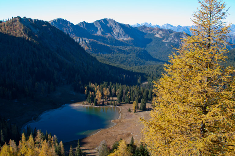
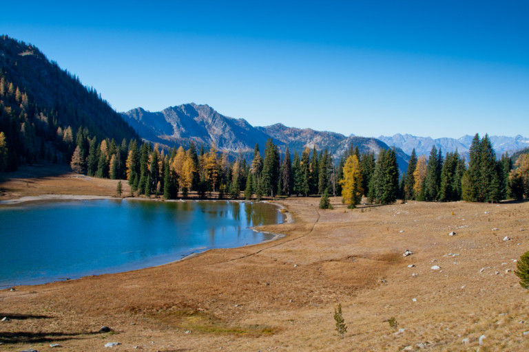
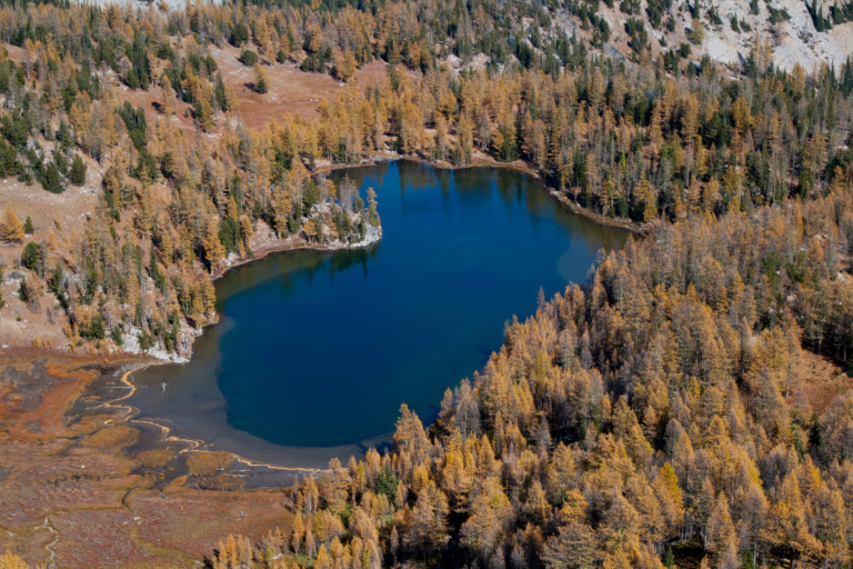
At a knob of granite, stuck out like a lookout tower, there’s a small campsite, and it’s clear why the last occupants chose this location, for it’s a perfect viewpoint across to the granite towers and below you can see the surface of Lower Eagle Lake, shimmering in the sun. Granite slabs stacked upon one another, almost like tomb stones, create a bench that sits around a campfire ring, on this solid knob of granite. Did Frodo and his merry bunch stop here to sup? Hard to say, as the images of fantasy seem to fit right in here, you expect to see the characters from the Lord of the Rings inhabit such a place. The larch have also started to grow here on this side as well, interspersed among the thinning firs, and it reminds me somewhat of the Enchantments, another granite dominated, beautiful lake basin in the Stuart mountain range. Now, the path leads slightly down into the Upper Eagle lakes basin, and the cut-off for the lake is reached at the 5.65 mile mark. It’s a slight trail, not well used, that you can see lead off to the right, no sign to mark the way. If you miss the cut-off, and continue on the main trail, you’ll know if you’ve gone too far, for you’ll see a very shallow run out of the upper lake, a small patch of water that looks too scummy to drink from. At this point, really, if you just head upstream from this, you’re bound to run into the upper lake.
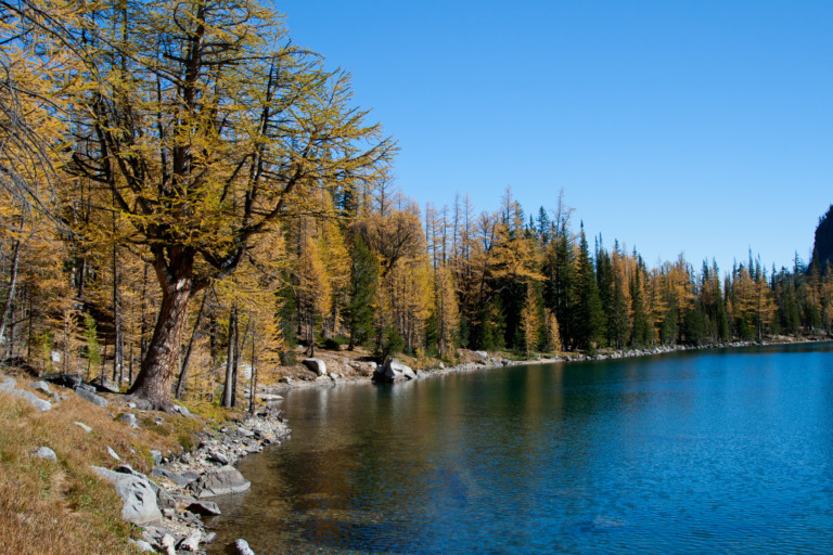
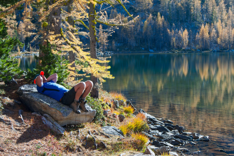
The last half mile to the lake, is like walking through a park. Grasses cover the ground, now gold-brown, mixed in with a low growing huckleberry that is now scarlet in color. Some of the broader leaved grasses are yellow, and the combined varieties create a matching carpet to the gold above. We are now walking through some of the biggest larch trees I’ve ever seen, both at the base and in height. Some of the lower branches are already bare, and the falling needles have covered the trail, adding to the solid golden ground cover.
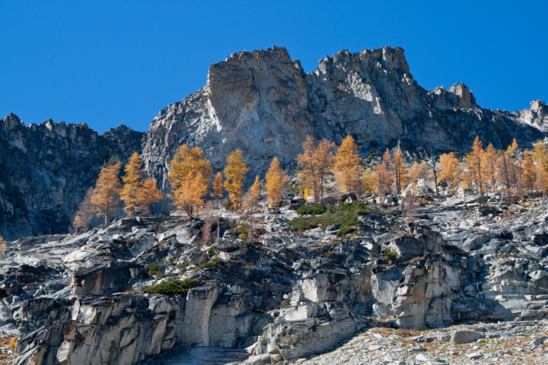
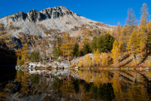
As we reach Upper Eagle Lake, all I can say is wow…There, between the arches of the larch trees; I can see a majestic looking peak, a white granite fortress of rock on top of the high ridgeline of jagged granite above. Sheer, steep, and flat sided; it’s in stark contrast to the crumbled and jagged peaks around it. Its name is Mount Bigelow, and it sets triumphantly above Upper Eagle Lake. Reaching the shores, we look around for the best site, as there is no one around to challenge us for it, and decide it’s this one right as you first walk into the lake basin. It’s a little windy, so we pitch our tent under the trees, hoping to use their trunks as a wind break; our hands are already becoming numb from being exposed.
“…the blackened rock looking as if it had endured some long ago bombardment…”

Checking my little key chain temperature gauge, it says the temps are around 48 degrees, at 1:30…With camp set; now we can dedicate our time to taking pictures of the area, and the massive amounts of larch. Upper Eagle is set in a horseshoe shaped basin, ringed on 3 sides by the hulking ridges of solid granite that is predominant here in the Sawtooth Mountains. The end of the lake is topped by Mount Bigelow at the NW end, and trailing down the ridge on its western banks is a procession of blackened granite spires, like a primeval remnant of some long ago battle, the blackened rock looking as if it had endured some long ago bombardment. At the lakes run-out, the ground is flat, and it’s here that there are the largest groupings of fir and larch. Around the camp, the trees are more dispersed, creating more open areas. That, too, is covered in grasses and fallen needles, adding to the park like effect.
“…Dan had not heard them, and he asked me if I was sure I hadn’t been dreaming…”
There are many campsites here, and it looks as if it were once popular with the equestrian set, for there are old dilapidated hitching posts, ready to fall down, and fire rings, and one in particular actually has a metal frame inside the rock ring, complete with an iron grating and warming plate, which can rotate above the grating! Of course, we’re a little amazed to see this. Lots and lots of pictures later, we grow tired from our long trip, and take an hour long siesta to re-charge the batteries…Around 4:00 or so, I remember hearing voices, and it sounded as if they had arrived on horseback, I can hear the clop, clop of what sounds like hooves hitting the hard baked ground, and voices above that, saying something about somebody already being here. By the time I exited the tent, they were already gone. Dan had not heard them, and he asked me if I was sure I hadn’t been dreaming…
Dinner time! We re-try the recipe that Greg had brought during our time in the Lyman Lakes area, and it goes over well. Smoked salmon in angel hair pasta. Yum! Really tasted great, might even have to try it at home sometime…
“…slowly moving satellites, plotting their constant course through the heavens, a bright light on a steady line…”
Dinner dishes done, everything stowed, we set around waiting for night to fall, and are not disappointed by the bright stars overhead, mixed in with an occasional meteor streaking quickly across the sky, contrasted by the slowly moving satellites, plotting their constant course through the heavens, a bright light on a steady line… It helps to take our minds off the cold night air, for it has dipped into the upper 20’s, and our light gloves are almost not enough…Right around 9:00pm or so, I remember looking uphill from our camp, in the trees, and seeing a headlight bob around in the darkness.
Look! There’s someone else here! It’s startling, for throughout the day, we heard no one else other than the people on the horses…At least, I thought they were on horseback, maybe they weren’t, and perhaps the loud clopping sound was just their footfalls walking on dry, brittle ground??? Don’t know for sure, but at least now I know I wasn’t dreaming…Once in our warm bags, sleep comes easily, and the night is uneventful.
Day 2
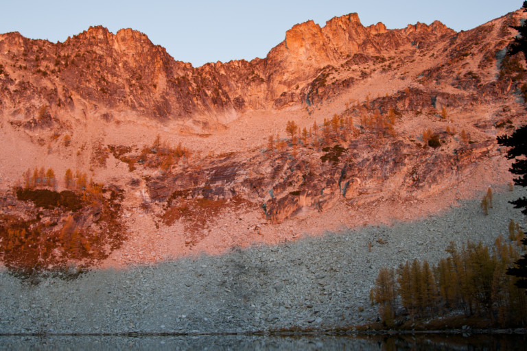
8.7 miles, 2737ft gain/2567ft loss. Getting out of the warm bag to greet the cold morning was more difficult than I thought it was going to be, but once outside, you just had to marvel at the sunrise as it played across the peaks around us. The thick smoke from the forest fires had at least one positive side effect. The mornings first light filtered through it created some of the reddest sunrises I had ever seen, and even now, sitting at home looking at the pictures, the red seems unnatural, as if photo-shopped, but…No, that is the real color! For 20 minutes or so, we enjoy the spectacle, snapping as many pictures as possible, not wanting to miss this. The later morning light would finally reach the tops of the larch at the southern end of the lake, and the result was spectacular, looked as if they were neon on Broadway they were so lit up…
Packing everything and leaving this idyllic place brought a sense of regret, I wanted to make sure that I had done a good job of documenting this place with enough good pictures, but of course, I wouldn’t know that until after reaching home.
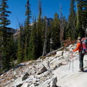
We head back out the way we came, (on numb toes, I might add), take a right on our loop trail, and get no further than a mile before the views start opening again onto white granite peaks and golden larch. At this first mile mark, you will pass the cut-off for Lower Eagle Lake, and looking southwest from this point, you will be looking straight at a large amphitheater of rock, with larch clinging to its slopes. Its name, according to Google Earth, is Cheops, a dramatic peak here along the ridge, connected to Horse Head Pass, which we we’re heading for now. The trail zigzags slowly uphill along this ridge that forms the southern edge of the horseshoe bowl that protects Upper Eagle Lake, to the pass, and as we near the saddle, the trail becomes very rocky, large chunks of white granite having fallen from the steep rock above.
“…The larch below march right up to the large outflows of the talus fields…”
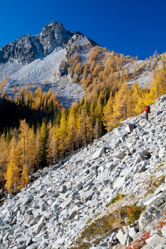
The trail does an excellent job of crossing this white talus field, and mingled in amongst the rock are large larch trees, growing perfectly along the trail as if
planted by a master gardener. It truly is a beautiful walk from this point to the pass, and you hardly notice you’re going up, for every step is taken eagerly, anticipating what majestic view might be just around the next bend. The larch below march right up to the large outflows of the talus fields, reminding you of a white lava flow that had cascaded down the slopes, covering everything in their path, then stopping at the borders of trees. Letting your gaze continue past the tree line below you, the sparkles of sunlight reflecting off the surface of pretty Lower Eagle Lake catch your eye. Looking beyond the lake, you can see distant ridgelines folded up one after the other. Very scenic and hard to tear your gaze away, but…We know we’ve got a distance to go, and another couple passes to go over before reaching our destination for the day.
Quickly, it seems, we continue at a steeper pace switch backing uphill to Horse Head Pass. It’s windy here, and still early, for we’ve reached the pass in only 1.59 miles, at 7190ft elevation. Again, we feel compelled to stop and take pictures…The views both east and west here are worthy, for west you can see what we’ve been gawking at for the last mile or so laid out before us, and to the east are distant snow covered peaks in the Glacier Peak wilderness, and closer in, the mountain tops and ridgelines on the other side of Lake Chelan. Closer still, and just beyond the valley below us, is Old Maid Mountain, almost lost against the constant ridge after ridge of rugged mountains beyond. And, below us in the valley, is Boiling lake, another blue-green shallow lake with huge meadows around the water’s edge, leading right up to the very slopes we are about to go down. We continue to marvel at the huge views that seem constant so far on this trail. The way continues down the backside of Horse Head Pass, on easy on the knee switchbacks, never giving you the impression that going downhill is steep, another thing for us to marvel at.
“…adding to the feeling that we’ve just wandered into a state park or some rich land barons holdings…”
We finally reach the base of this ridge at 2.7 miles, and enter the massive meadows here; it’s like some huge park! And, adding to the feeling that we’ve just wandered into a state park or some rich land barons holdings, we’re confronted once again with picnic tables, and fire pits! Amazing, simply amazing…I’ve never seen anything like this, so far into the backcountry! We wander closer to the lake, trying to take it all in. Back at the trail junction to lead us to Cooney Lake, the sign states the way to Cub Lake. This is trail #1259A on the TOPO map, and as we follow our preplanned route on the GPS, it’s clear that the trail has changed directions since the map drawing. Not only that, here from Boiling Lake, (on the TOPO map) is a confusing array of trails leading this way and that, collecting somewhere again along trail #1259…
I figured this was probably going to lead to some head scratching when I got here, the reality it seems rarely matches the map trails in an instance like this, and I wasn’t disappointed. The trails that should have been there seemed to be missing, or not in the right place, but, I figured as long as we follow the trail that seems to lead in the right direction, it’s probably the correct one. Sure enough, this trail led us down the creek bed to its junction with trail #1259. Just not in the place one would have guessed by looking at the map, and when you get to this junction, you’ll have to pay close attention on which branch to take, as they meet up in an X style junction…This junction is appx. 1.1 miles from the Cub lake junction at Boiling lake, and 3.8 miles total from Upper Eagle Lake. Just as you cross the creek, there are 2 picnic tables here in the meadows near the junction!!! Again, amazing…As you approach the trail junction you will see two branches heading west, one slightly uphill, and the other almost straight across from you. The trail to your direct left, looking as if it’s almost ready to head back the direction you came, is the one to take. You’ll know you’re on the right path, for in about 150ft it will cross Prince Creek, the other trails do not…This, on the sign, is also called the Summit Trail, a fact that you will not find on maps. It quickly disappears into woods again, although it continues on the nice flat dirt that you’ve grown accustomed to, as it heads uphill once again.

“…like walking on a golden strand carpet…”
But, it’s not long, before you get good views again through open meadows uphill to the back side of Cheops peak in .77 miles. It’s also at about this distance, you’ll see the old trail veering off to your left, and this seems to match what the maps show. Stay to your right on the main trail. Approaching the leading edge of a ridge that forms a saddle between Old Maid Mt. and the mountain range you still need to cross, at mile 5.4, you’ll come across more wide open, picturesque meadows that seem to go on forever, ringed at their edges with more larch and stands of alpine firs. There seems to always be something new to see and photograph on this hike, and we’re amazed that this trail just continues to give us awesome views. As we approach this small ridge, we come across more wide open grasslands, and continued stands of golden larch, by now many have dropped their needles, and the trail is covered in fine needles of gold, giving you a other worldly experience, like walking on a golden strand carpet.
“…I look around for a Lorax, sure that I’ll see one bobbing in and out of the mystical trees…”
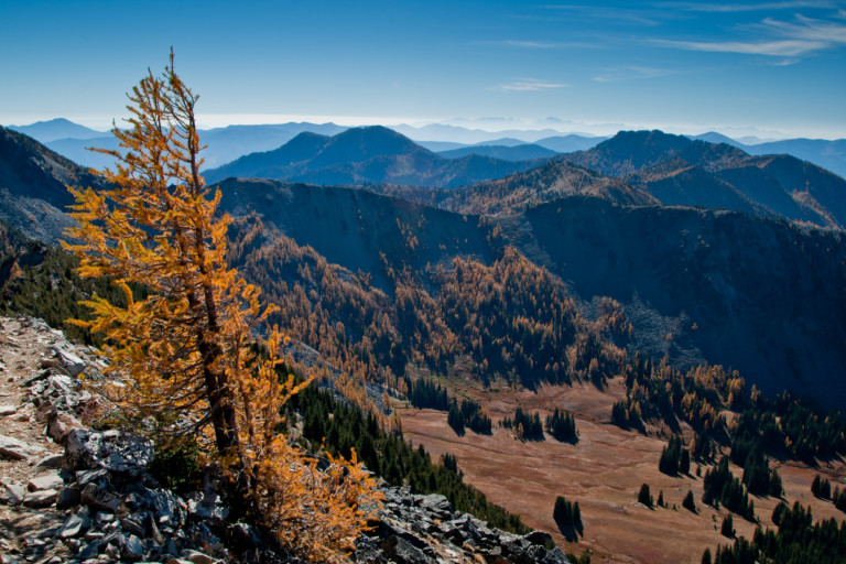
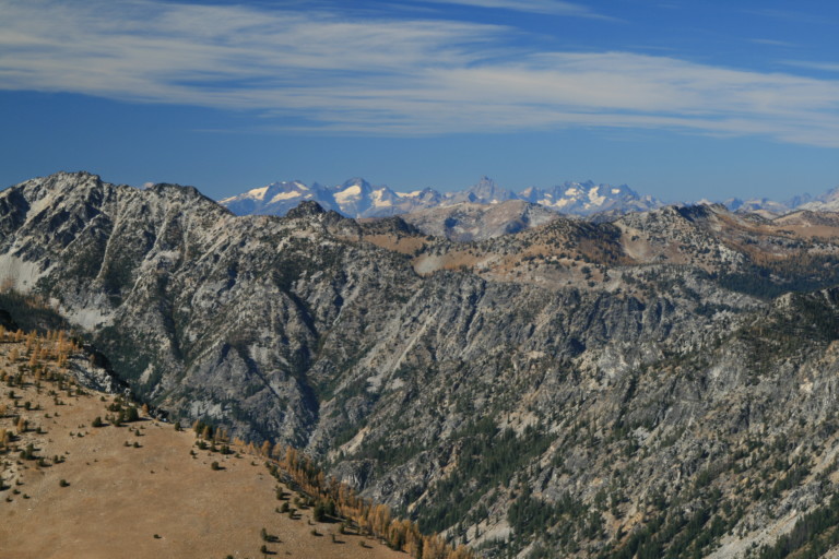
So far, we’ve seen more larch trees than any other hike we’ve been on, putting on a dazzling show of color. I call this Larch Pass, for it has no official name on the map, but once you’re here, you cannot mistake it for it takes on the quality of something that Dr. Seuss would have written about…I look around for a Lorax, sure that I’ll see one bobbing in and out of the mystical trees…After cresting this ridge/saddle, you cross over into more wide open hillsides that are covered in the golden brown grasses that insist on covering the rolling slopes, reminding you of something you would see in wetter climes, like northern California. The mostly bare slope to the north of us culminates at the top of Old Maid Mt. Dotted here and there with green firs, and golden larches, it truly is a unique landscape. With the Sawtooth ridgeline still on your left shoulder, you will continue to walk through inclined meadows that run all the way up to the bare granite, all the way to your next turn-off at 5.9 miles, a trail that will take you up and over the Angel Staircase, trail #417. This is the only real steep part of the trail, and you will gain about 1000ft over the next 1.45 miles. It does a great job of switch backing up and over the ridgeline though, and the higher you go, the rockier it gets, until you’re walking on nothing but barren rock, to your high point at 8100ft. During this upward trek, you continue to get incredible views to the valley floor below, and distant peaks covered in snow.
Eventually, you get high enough to see massive Glacier Peak in the distance, west across a jagged line of peaks, too high to be completely blotted out by the impressive array of mountain tops. Looking north, you can see the spires of Goode Mt, Buckner Ridge, Sahale, and more standing proud above the rest. We stop to take in the views, and are amazed to see a couple of mountain bikers here at the top, heading down the way we had come up. We’ve now travelled 7.35 miles, only a little over a mile to go, and still, the views do not let us down. After reaching this pass, it side hills below aptly named Switchback peak, the shoulder of which you just crested to get here, and crosses over mostly downhill to the next saddle, which will take you down into the Cooney Lake basin, our destination for the day. As we look south, another valley stretches out below us, Merchants basin, and there, hanging in another horseshoe basin of the Sawtooths, is blue green Sunrise Lake, barely visible at this distance, setting below Sunrise Peak.
“…that we almost ( I say, almost) view it with a blind eye…”
There’s a trail that runs down into the valley below us from the saddle we’re headed for. So much to explore here! Finally at the pass where we head down into the lake below, we have a good vantage point to spy out the lake. It too, is surrounded in a sea of gold, its deep blue waters highlighted by the color contrast. Again, you have long distance views as far as the eye can see, finally fading in the distant smoke hazed horizon. Watch your step here as youhead down, for the trail here is loose rock and steep, and it gets you to the shoreline in short order. From the saddle to lakeshore, its only .9 miles, but you lose 900ft. The last few .2 miles or so, you once again wander through a park like setting, gold trees line the path, and it’s amazing how big some of these trees are. A master gardener would have had an impossible time of planting everything so perfectly, but by now, we’re so jaded with all the big views that we’ve taken in over the last few hours, that we almost ( I say, almost) view it with a blind eye.
“…Several pictures later, and interest waning…”
Finally at the lake, we drop our packs at what seems an incredible spot, with views back across the lake to the hulking peak that sits, unnamed, at the far shore, casting a shadow on the western edge. After a few minutes of wandering, it’s clear that this spot at the most eastern shore, is the best, so we make camp, then wander around, cameras in hand, trying vainly to find that perfect shot of this new lake. Several pictures later, and interest waning, we head back to our perfect lakeshore camp, and prepare a meal, but not before taking a few minutes to sun ourselves, for it has been a cool day, the wind blowing against sweat soaked shirts only helping to remind us that fall has set in this part of Washington.

“.. this can’t be the way, I don’t see any tire tracks!”
Dinner eaten, and camp chores completed, we bundle up, having had a taste of how cold it can get after last night, and here at 7300ft, we’re sure we’re in for another cold eve. Before dinner, as we were setting around enjoying the warmth of a fading sun, we heard voices, and were surprised to realize it was two mountain bikers that were on the pass above, looking over the lake. I could hear them clearly, as if they were standing right next to me, say, “ this can’t be the way, I don’t see any tire tracks!” Wow. That’s almost a mile away, and he wasn’t yelling. Obviously, there is no wind down here, and everything is as still and quite as I can ever remember, but it still is shocking to me that I could hear that so clearly…
Another great thing about this time of year is…No bugs! No constant droning, buzzing, and biting, causing us to constantly swat at the air around us, as if we’d lost our minds, something I swear the annoying insects have in mind during their onslaught…This, also, seems to add to the unnatural quite.
“…and his howls would echo off the cliffs…”
Night and we again enjoy the wide open views of the Milky Way overhead, and the pinpricks of light from distant stars that poke through the darkness around us. The quick flash of meteors burning up after entering our atmosphere add to the night sky, and so too does the lone coyote wail that pierces the night around 9:00pm, as if to say that he, too, enjoys the show. At first, it startled us, for wearing balaclavas kind of blocks out yourhearing a bit, so at first it was muffled. He went on for 20 minutes or so, and his howls would echo off the cliffs at the end of the lake, as if answering himself. Funny thing is, we never heard another answer back, and knowing how well the sound travels here, it was hard to pinpoint his location, but it sure sounded near. I tried recording it with the camcorder, guess I’ll find out when I get home if we got it…
Day 3
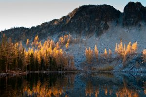
8.6 miles, 992ft gain/3532ft loss. Another brilliant morning, where we awake to a gorgeous sunrise, that colors the opposite cliff face a blood red. The pictures look unnatural, they’re so red, but its fleeting, for in about 20 minutes, we get the full on sun, and the red quickly fades, shining on the peak opposite the lake, highlighting it’s crevices, and angular lines for the first time since we’ve been here, making for some great reflection shots on the still lake. Storing cameras and gear, we leave Cooney Lake, sure that someday, we’ll be back this way again.
“…the sunny skies are doing their best to chase off the cold…”

It’s been an awesome hike, so rare to spend two full days of big views…The trail heads out through meadows at the northern edge of the lake, and steadily winds down hill through more of the golden grass covered meadows and hillsides that we’ve grown so accustomed to on this trek. Looking back towards the lake, we get one more glimpse of the saddle and granite peak that bordered the opposite shores, before reaching the Cooney lake cut-off that covers a completely frozen stream, so frozen that we could step on the ice without breaking through. Did I mention it was cold again last night? Yep, dropped down into the upper 20’s again, and it’s still cold this morning, although the sunny skies are doing their best to chase off the cold.
“…Think of it as more of a suggestion, than the rule…”
The cut-off is reached in short order; a scant .2 miles from the shores of the lake, and you will turn left, onto trail #429, and continue your downward descent. As you will for the majority of this way home. Cutting along the southern slopes of Martin Peak, you’ll get your last good open views of the area before dropping into the tree line, and there are still a number of golden larches mixed in with the now increasing firs, leaving splashes of color against the green. Then, the open areas succumb to the tree line, and the way continues downhill, but not at a knee burning rate, just a nice, gradual walk through varied forest on a nice, dirt trail. If you look at the GPS overlay on a TOPO map, it’s clear to see that the trail no longer follows what the original route called for, especially once you pass the Martin Lake trailhead. Think of it as more of a suggestion, than the rule…At least, according to my Garmin GPS unit, the Oregon 450t, a new purchase, which I really like, by the way…
The trail goes around the leading edge of a ridge that runs down from Martin Peak here, and at 2.07 miles, you’ll get one more open area, with larch trees growing up the steep talus fields that have crumbled off the edge of the ridge, looking back up at Martin Peak. This is just before the Martin Lake trail, in another .2 of a mile, at 2.27 miles. There’s a sign here, pointing the way to Martin Lake, and another marker pointing the way to Golden Lakes Trail #431, which, of course, is the way you’re headed…
The way down from here, goes through increasingly denser and larger old growth firs, hemlocks, and cedar, as it follows the Martin Creek drainage to the trail junction. So, for the most part, we just kind of put our heads down, and concentrate on the trail ahead of us, and making good time, for the most part without talking, each one of us lost in our own thoughts, occasionally adjusting the load that rides on our backs, and listening to the sounds of boots stomping down the trail, and packs creaking from the weight of the gear stuffed in. It continues like this all the way to the creek that runs out of Eagle Lake, at 5.4 miles, and along the way, we encounter a huge group of mountain bikers, heading uphill.
“… I have mixed emotions about sharing the wonders of this incredible place…”
From the creek bottom, the trail goes uphill, to rejoin the Golden Lakes trail, #431, and does so for most of the only elevation gained this day, about 350ft in the next .9 miles. Here, at 6.36 miles, you reach the trail junction you passed on your first day, and head back downhill to the parking lot. Just as we reach the trailhead, we meet our first backpackers! They’re just heading out, at 12:30pm, hoping to reach Sunset Lake, a lake we saw on our second day…Wow…Good luck to them, is all I can say…They would be the only other backpackers we would see on this trail, and I am really surprised, seeing as how beautiful a hike this is. Dan is convinced it’s the best hike he’s been on, and I have to say it’s hard to argue with all the huge views, gold larch, stark white granite spires and peaks as backdrop to some of the most incredible mountain side meadows we’ve ever seen. The lakes interspersed at good intervals for camping, also adds to the beauty that is this part of the Sawtooth Mountains, and I have mixed emotions about sharing the wonders of this incredible place. Do I keep it a secret, for just the few that know about it or do I bring home the pictures and memories to share with others, in hopes that they, too, will be as enthralled with it as we were. I vote to share, and it’s our intention to lobby our friends to set aside time next year to join us on a truly unique experience that is, the Sawtooth mountain range.