Day 2
10.7 miles, 3566ft gain/3374ft loss.
“…I was only off by a mile!”

You would think, after time, that I would remember that when at home poring over maps and tracing routes on the “current” TOPO maps for mileage, that I would remember that in actuality, when boots are on the ground, that the mileage never matches. Ever. But, trying to be an optimist, (something that I’m not really that good at), or perhaps in an attempt at hiding from Greg and myself the true distance, I “optimistically” proclaim after much studying and planning, that this first day will only be 9.7 miles! I was only off by a mile!
“…I spent the rest of the night scrambling to see what I was going to do about that. Appears nothing…”
The second shock came, as I turned on the GPS, at home, the night before we left for our trip, and was stunned to see no TOPO map on my GPS! Doh! We’re going to be in IDAHO, not Washington or Oregon! The thought never donned on me until I turned the danged thing on to make sure that the routes I had traced on Trimble had indeed been loaded…I spent the rest of the night scrambling to see what I was going to do about that. Appears nothing, as the Idaho maps cannot be downloaded from the web….Still, through much digging, I found that TOPO, with an annual fee, will allow you to make maps on their sites which you can then download and print at home. Well, at least that was a start, so I was able to create a custom 11×17 inch map of our routes. At least we wouldn’t be empty handed, and have some idea of the terrain we were about to embark upon. That, and try and stay on the little line in the middle of my now featureless GPS screen….
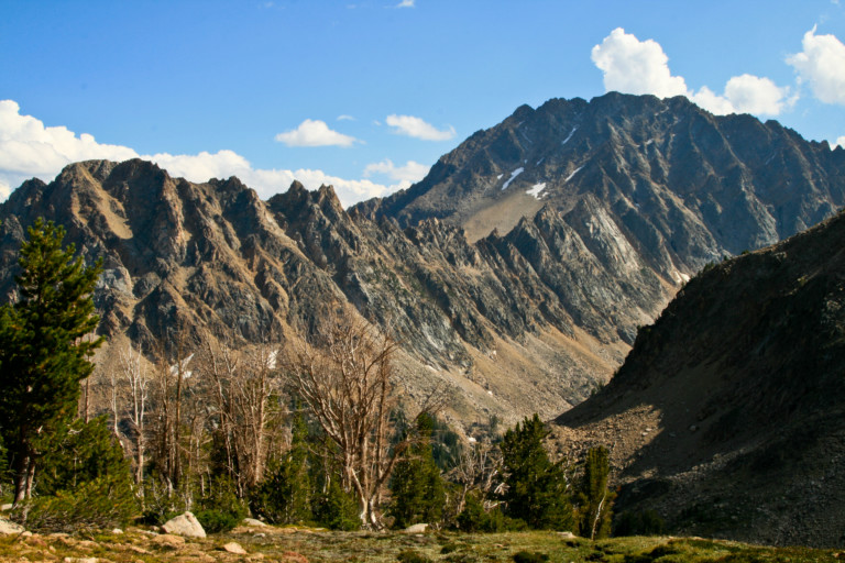
After hitting the Starbucks, it’s on the road to the TH. It’s a beautiful drive, with large mountains rising up from the flats on either side, and as we approach our turn off, the majestic Sawtooth Mountain range looms large on our left, with impressive bare rock formations that just beg to be explored. It’s no wonder this place is so popular. Turning right onto Fourth of July Creek road, which is Forest Service Rd #209, you can see the road disappear into more large, rounded hills, a little disappointing considering the incredible jagged peaks that are now behind us.
The road passes through a free range area, and we’re chased by 4 large white dogs, Greg thinks they are Great White Pyrenees, and they bark and snap at the tires as we drive by. Some guys on motorcycles had passed us, and got the full treatment before us. On a motorcycle, it appears that speeding might be the best solution to avoid being pulled off, not sure I would want to ride a bicycle past them. Past the dogs guarding the flock, you drive through a fairly recent burn, looking like a forest of telephone poles. The trailhead is large and well maintained, with the cleanest pit toilet I’ve ever seen, or smelled!
“…and it wastes no time getting uphill to a small unnamed lake where we will leave the trail…”
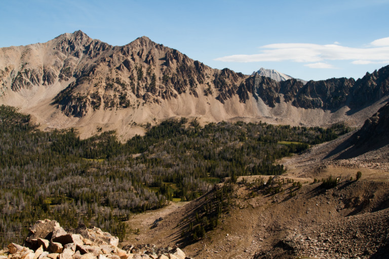
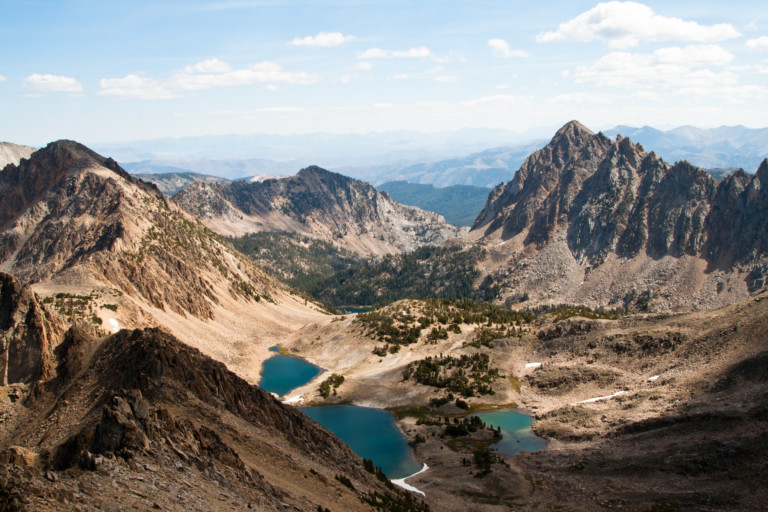
Packed, we’re on the Fourth of July Creek trail at 9:30am, and it’s a well-used path that gradually leads up through pine and alpine fir. It’s arid here, so the brush is at a minimum, just one of the things I love about eastern slopes, and high desert. You can actually see through the trees. At 1.78 miles, we reach our first turn-off onto a trail that heads left onto #219 towards Born Lakes, and it wastes no time getting uphill to a small unnamed lake where we will leave the trail. At this lakes shoreline, we can see the ridge we have to climb up to, before traversing ridge to the top of Patterson Peak. The trees quickly fade as we scramble up the south side of the lake to the top of the ridge, over loose rock and sandy soil, gaining the top of the ridgeline at 2.7 miles, and just over 10,000ft of elevation.
“…Having to down climb a face with loose rock? Hard to say until we’re all the way up…”

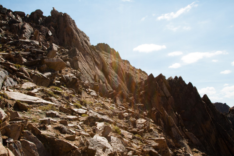
We can look down now into Ants Basin, on the other side of the ridge and back SW across the valley we just came up through, the lake below us now seeming small and insignificant. Truth is, it was kind of insignificant just standing at its edge…In the distance, you can still see the spires and peaks of the now distant Sawtooth Mountains. The wind is blowing here on the ridge, cooling us quickly with gusty winds over sweaty shirts. The top of Patterson looks pointed and shattered, with large boulder fields spread out below the peaks. Our route, loaded onto the GPS at home looks to take us right up along the spine, sure hope we can find a way through the jutted rock on top, because from here, it looks as if you would have to climb up vertical rock and who knows what’s on the other side, a sheer drop off? Having to down climb a face with loose rock? Hard to say until we’re all the way up, we just don’t want to have to backtrack.
We get up and over our first little peak, and to our relief, the other side is just as accessible on the other side, down to a wide saddle that provides more dramatic and incredible views. We’re now looking down into the Born Lakes basin, and can make out at least 3 lakes in the trees.
“…reminding me of wind blowing curtains back & forth on a lone window in a dark room…”
The sun shines brightly through the clouds as the wind drives them by, reminding me of wind blowing curtains back & forth on a lone window in a dark room, allowing the light of the day outside to flicker briefly in and out, cutting through the darkness. As the sun shines bright, it illuminates the stark granite faces of the opposing mountains, creating a contrast of light and dark lines on the ridged pinnacles. Since there is little color here, other than the varied color of the rock, mingled white, red, orange and yellow, it seems that black and white photography would excel here, high above the tree line. Its’ a beautiful sight, stark and bare, slightly foreboding, too, a grim reminder of how unfortunate it would be to fall here, or get trapped by a violent storm. As far as the eye can see nothing but pinnacled peak after peak, stretching far into the distance.
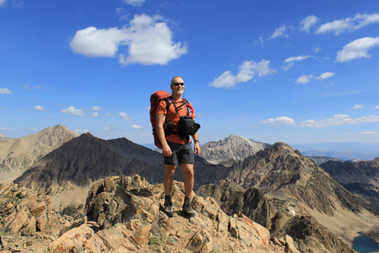
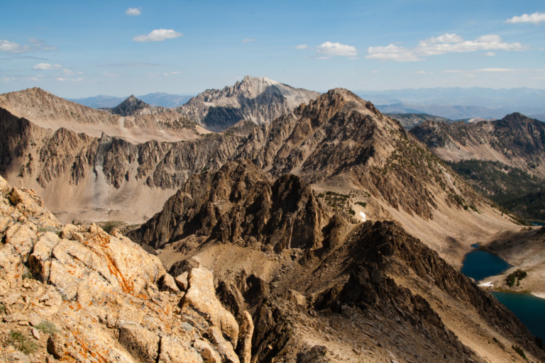
We continue up the ridge, looking more and more as if we’re climbing up the spine of an armored beast of old, whose sharp jagged scales line the edge like broken glass. Still, we’re able to find a route all the way to the top of Patterson Peak, at 10, 875ft elevation, and at our 3.38 mile mark. It seems to be the highest thing around giving you a bird’s eye view for awesome 360 panoramic views.
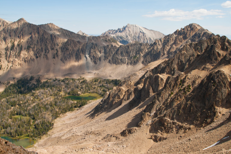
Now we can see down into the Four Lakes basin, our next destination along the way. It looks steep down into the lakes from our perch, but very doable, so we make our way carefully down the loose rock into the basin. It looks as if there have been a few people to come this way before us, for there is a faint trail downward, occasionally the boot prints disappear over the areas of solid rock, but looking further downhill you can once again see footprints in the dirt and sand.
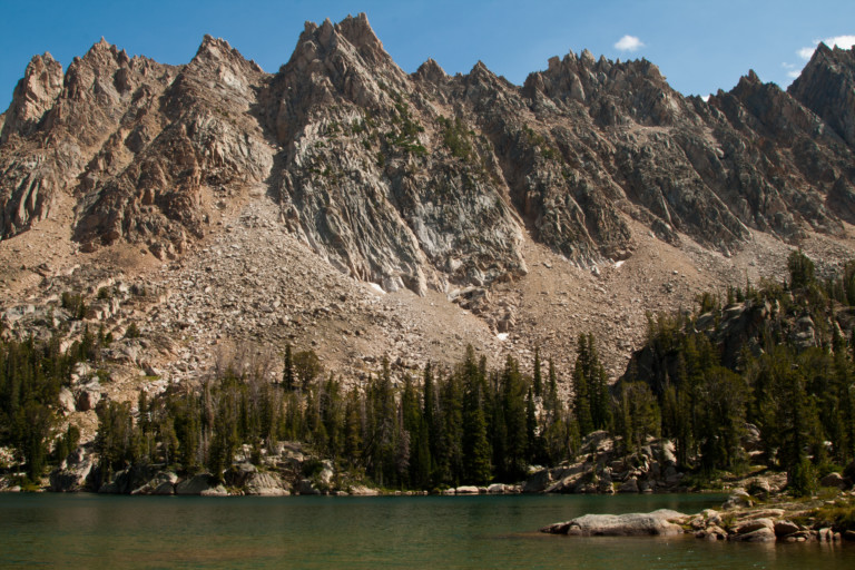
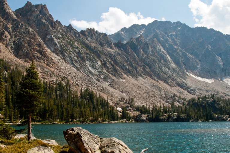
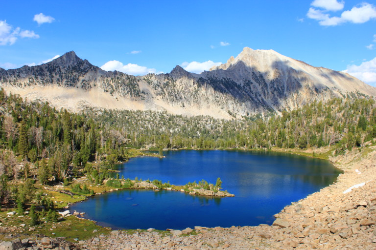
As the grade lessens near the bottom, the rocks become larger, and it’s a boulder hop to the first of the lakes, named Glacier Lake, a small shallow tarn at the edge of the boulder field. From its banks, it’s a short walk to the next two lakes, separated by a narrow spit of land with a few trees dotting the banks. The lake to the right, named Rock Lake is intriguing with the color of the water and the small boulder islands jutting up from the water’s surface. Grassy hummocks border the thumb of land that sticks out from the slight rise that separates the two lakes. The lake on the left is called Emerald Lake, and it is the largest of the small band of lakes here, surrounded on all sides by bare rock and boulders that have tumbled down on the west shore from the heights above, a ridge that separates this basin from Ants basin on the other side.
“…creating lazy bends that pool before dropping over another rock laden fold…”
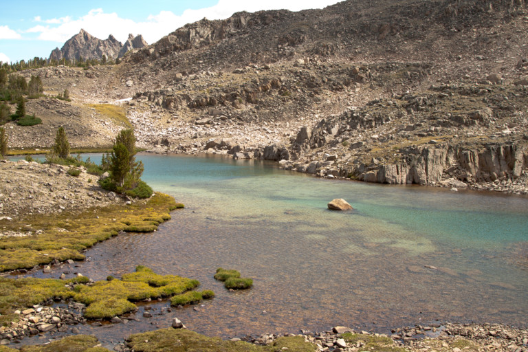
It’s so fascinating in this area of blasted rock, barren and ancient, to find such a collection of clear, turquoise waters. The outlet of Emerald feeds a smaller lake in this basin bench, called Cornice Lake, and the outlet from this lake pours downhill through a narrow gulley, which in turn feeds Quiet Lake below. The stream becomes far less insistent on its downward plunge, creating lazy bends that pool before dropping over another rock laden fold. The small waterfalls lead to more flat spots where the water again pools, splits, and moves around rock and dirt, creating stepping stones of small, park like settings. It drops like this a few times before reaching the banks of large Quiet Lake, another beautiful and scenic lake.
“… dominated by Serrate Ridge, a huge succession of peaks, like rows of shark’s teeth…”
We keep to the west shoreline following a distinct beaten path past a few well-chosen campsites to the opposite bank. Trees and grassy areas grow along this shore, but never completely block out the bare granite or views. The eastern bank is dominated by Serrate Ridge, a huge succession of peaks, like rows of shark’s teeth dominating the skyline, an impressive backdrop to this pristine lake. The view is so incredible, we stop for a while at the 6.2 mile mark, on the far shoreline for a quick break, and another chance to make sure we get enough pictures and video in hopes of getting that one shot that will capture the incredible view across the lake.
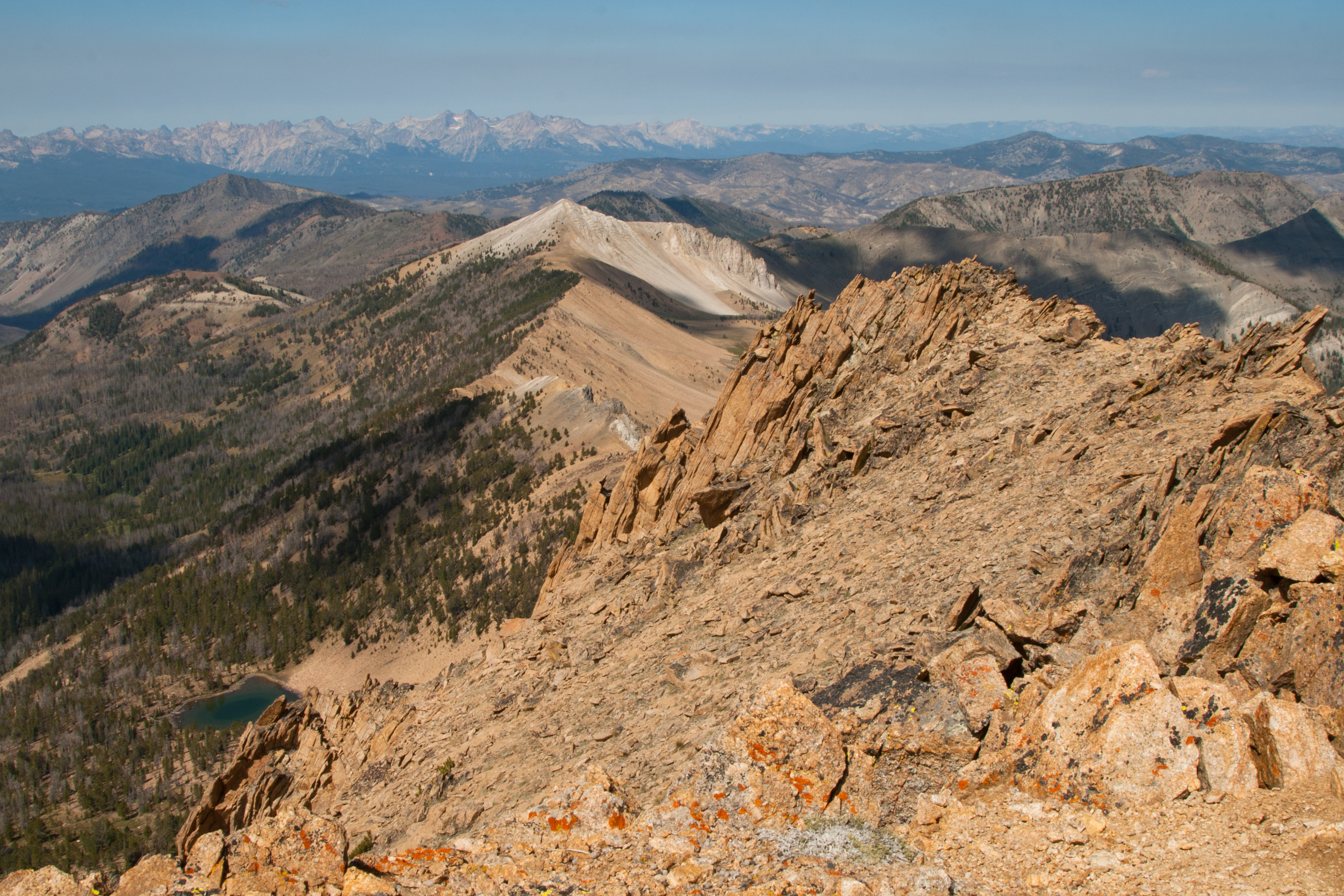
Now its uphill through a small slot in the cliff that holds back Scree Lake, a small tarn in a bowl valley above us, and once we clamber up and over the edge, we have to drop back down to lake, skirt the opposite edge, then follow another inlet stream uphill to the banks of another stepped lake, called Shallow Lake, which is indeed shallow, and it sets just below another bench that we must climb up to. This lake is at 9650ft elevation and here on the north shore before heading up, we’ve now covered 7.3 miles. As we climb this hill to reach the top, lungs and legs start to get tired, and when we get home, I’m able to see that from Shallow lake to the small unnamed tarn that sits at the top of the bench, its only .3 miles, but gains about 430ft of elevation in that short distance! Steep by anyone’s measure…
“…Which to focus on; the granite peaks that hem us in, or this idyllic valley with trees and grass dotting the barren red tinted granite…”
Finally, we reach the top and catch our breath next to this tiny unnamed pool; we look around for the trail that TOPO maps show being here. We never find it, however, until we drop down the ridge to Windy Devil Pass, in a saddle between the peaks here. More expansive and incredible views from the pass, looking north there is a ridge with 3 peaks that top 10,000ft and are unnamed on the maps we have, this ridge hems in the Chain Lakes basin that now sits at our feet, a succession of lakes that feed one another. You have to turn your head to take it all in. The landscape is just too large to fit in the viewfinder. Which to focus on; the granite peaks that hem us in, or this idyllic valley with trees and grass dotting the barren red tinted granite, surrounding the lakes that sit in the bottom of the Boulder Chain Lakes basin.

“…Kind of like the difference between putting your car on cruise control as opposed to not having it. It’s just one less thing to worry about…”

Its’ hard to say which best represents the area; for they all have their unique charms and when added together create a landscape too big for normal lens to capture. Our cell phones get a work out set to panoramic mode here. We can see 3 lakes sitting below us and the basin goes around a bend, where more lakes surely wait. Finally, we’re on a defined trail! From the pass, the trail zig-zags downhill back and forth across a rock field that spreads all along this ridge down to the lakes below. It’s nice to finally be on trail so we no longer have to take bearings and think about the best route around or up and over the next rise. It’s not that it’s impossible or too hard to do, just much easier to not have to worry where to go next, the trail can make the decisions for us. Kind of like the difference between putting your car on cruise control as opposed to not having it. It’s just one less thing to worry about.
We drop down into the pretty lake basin, and meet the first people we’ve seen, a couple with a small dog. Stopping to say hello, they tell us they were thinking about heading up to the pass, but decided instead to watch us come down, living vicariously through us. We found out they were staying at Hatchet Lake, the lake right after our destination today at Shelf Lake.
“Is anyone staying there?” we asked, knowing there weren’t many places to camp at the lake, and they said they hadn’t seen anyone. Bidding farewell, we make our way consistently downhill past many more lakes, becoming jaded to the beauty of the area. Any of these bodies of water would be a destination in their own right by themselves, but strung together in this magnificent valley, it’s hard to discern each one individually.

Amazing, is all I can say of this basin. We finally reach Shelf Lake, backs and feet sore and tired from all the off trail mileage and obstacles. There is a nice site right on the edge of the lake, but we choose a spot that is a little off the edge of the water, where we’re sheltered from the constant wind that seems to be blowing here. Dinner, a little fireball, and it’s off to bed, a big day and another big one tomorrow.